Scarborough Bluffs EarthCache
-
Difficulty:
-

-
Terrain:
-

Size:  (other)
Please note Use of geocaching.com services is subject to the terms and conditions
in our disclaimer.
-- THIS IS AN EARTHCACHE, READ BELOW FOR LOGGING REQUIREMENTS --
The Famous Scarborough bluffs were named by Lord Simcoe's wife, who said they looked like the chalk cliffs of Yorkshire, near her native hometown of Scarborough england. Only after they landed did they discover that the cliffs were not made of chalk, but compressed white sand.
The Sand was deposited here 70 thousand years ago. At that time, a growing ice sheet had blocked off the st. Lawrence, causing much higher lake levels, similar to that of Lake Algonquin. Plant and insect fossils from the escarpment indicate that much of the Scarborough area was a Boreal delta in a very large glacial river, probably fed from the melt waters of the ever growing Wisconsan Ice Sheet.
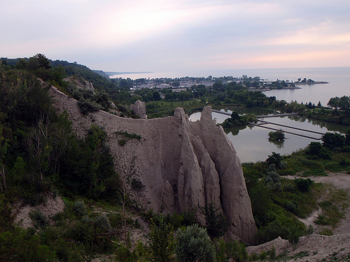
The Cathedral Sandcut
Insect Fossils and clays in the formation seem to indicate that the climate was similar to near-tundra boreal forest, resembling a patchwork of spruce groves, with grassy and rocky barren strips. July average temperatures reached a bomby 12 degrees C.
Eventually the glaciers covered the delta, and all the deposits placed by the river delta were crushed together under a kilometer of ice. This Hard packed sand is what makes up the "scarborough formation" that makes up the bluffs.
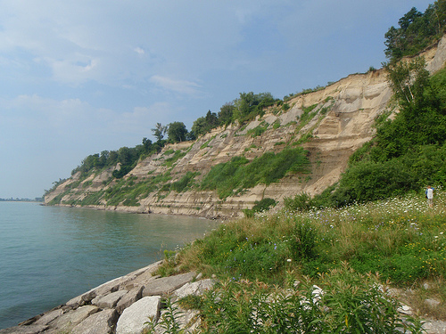
Naturally Eroded Shoreline
As the glaciers retreated, Lake Iroquois formed. The glaciers still blocked off the escape route to the St. Lawrence near the present day thousand islands, and so the lake grew. The lake was 30m higher then it is today, and was drained through new york state rather then the St. Lawrence.
Erosion from the lake chopped away at the compressed sand coastline, and as the water level fell, the coast became more pronounced, and eventually became a cliff. Erosional forces like wind, rain, snow, ice, hail and water have made some impressive spires in the sandstone, as well as made some very pretty cliffs.
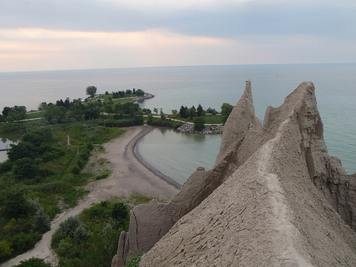
Narrow Trail to the Sand Spire
Manmade fingers jutting into the lake were installed by the city of Scarborough, and later by the city of Toronto after amalgamation to prevent erosion and save the pretty houses from slipping into the lake.
To Log this cache:
Posted coords are for parking in front of the bluffs. Find yourself a Nice spot along the bluffs, somewhere scenic. You can make this cache as long of a walk as you like.
- Find a spot at the top of the bluffs, take the coords, and the elevation
- Find the a spot close to the spot in step 1 (but at the bottom), take the coords and the elevation
- Find the elevation of the lake's shore
- Log your find with the following:
- Picture of you and your group at the top of the bluffs
- The coords of the top and bottom levels, along with their elevations
- "Image" of old shoreline against bluffs - Using photoshop, or a picture with a man holding a stick (or something else creative) show where the glacial shoreline of lake Iroquois would be if it was still around!
WARNING: Every once and a while people end up on the news getting stuck half way up the bluffs, and requiring the fire department to haul their sorry selves back to safety.. Dont be one of "those" people. There are trails at the top and bottom of the escarpment in many cases.

Click the logo to visit the COG website!
Additional Hints
(Decrypt)
Svaq n genvy gung yrnqf gb gur gbc orsber cvpxvat lbhe fcbg - Gung jnl vg jvyy or rnfl gb tb orgjrra gur gjb.. Be srry serr gb tb n zber punyyratvat ebhgr!
Treasures
You'll collect a digital Treasure from one of these collections when you find and log this geocache:

Loading Treasures