Gem Lakes EarthCache
-
Difficulty:
-

-
Terrain:
-

Size:  (other)
Related Web Page
Please note Use of geocaching.com services is subject to the terms and conditions
in our disclaimer.
From Smeaton, head north on Hwy #106 then turn west on Hwy #913. Or from Candle Lake, travel north on Hwy #120, then Hwy #913 east. Turn north off Hwy #913 at the sign to the Gem Lakes and follow the gravel road for about 4km to the start of the trail.
Time to hike all trails: 2.5-3hrs.
***Please stay on the trail at all times***
Facilities: Park access fee, parking area, outhouses, picnic table, barbecue (no wood), three campsites along the hiking trail – please register at the Park Office for camping and to obtain your Park Pass ($7.00).
Narrow Hills Provincial Park Office: N54 02.616 W104 36.747 - obtain your park pass here.
Detailed maps of the trails are available at the Park Office or can be downloaded (pdf) near the bottom of this link (Saskparks website): Things to Do in Narrow Hills Provincial Park
The posted coordinates are for the trailhead. Parking coordinates are at waypoint N54 11.685 W104 48.764.
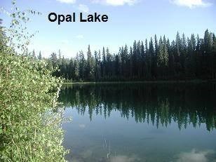
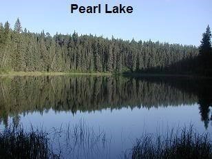
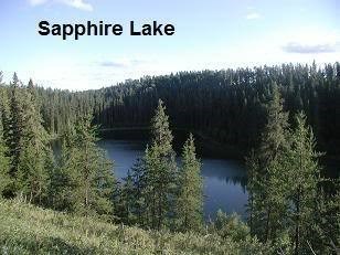
The trails near Jade and Opal Lakes appear to be well-used but as you get farther away the trail condition varies. The terrain is hilly and you may need to cross some fallen trees. Some trails go along the shoreline while others climb up onto the open wooded ridges above the lakes. Markers along the trails to farther lakes such as Pearl and Sapphire consist of flagging ribbon tied around trees.
To log this Earthcache as a find, you must post a picture of yourself (optional) or your GPS (required) overlooking the Gem Lake of your choice (mention the lake and camera angle in your log) and must answer the questions listed below, from signage found at various locations along the suggested hiking trail. Email the answers to me at karen.larsson@hotmail.com
Geological History:
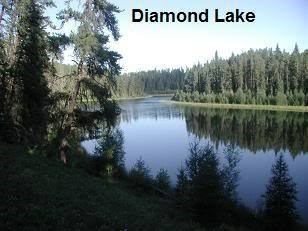
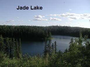
The Gem Lakes (Jade, Opal, Diamond, Sapphire and Pearl) are a part of a rare geological formation called "tunnel valleys", formed by glacial erosion where a series of steep, sandy bottom lakes were formed, separated by hummocky hills. The Gem Lakes and surrounding hills date back 11,000 years when the last continental glacier retreated from this area.
11,000 years ago, meltwater, flowing beneath the glacial ice, eroded bedrock and sediments laid down by previous glaciers to form a steep-sided channel called a tunnel valley. The Tunnel Valley here was filled with a deep layer of sand. Within the sand, large blocks of glacial ice got lodged, buried, then gradually melted leaving depressions called kettles. These kettles later filled with water, forming the lakes.
Although the Gem Lakes are very close to one another, there are no streams entering or connecting them.
Question #1:What source of fresh water fills the Gem Lakes?
Surrounded by forest, each lake reflects the blue-green color of the vegetation on the steep wooded slopes, hence their being named after gemstones.
The Boreal Forest:
Narrow Hills Provincial Park is in the Boreal Ecozone, a circumpolar zone that encompasses 1/3 of Canada and much of northern Europe and Asia. The boreal climate consists of short summers and long cold winters. Precipitation is typically greater than evaporation. The boreal forest acts like a filter to regulate flow of water into streams and rivers. It reduces the effects of global warming by absorbing carbon and lowering the levels of carbon dioxide in the air. The oxygen it produces is about one ton for every ton of tree growth. The boreal forest is critical in sustaining life on our planet.
Question #2: How many species of trees make up the boreal forest in Narrow Hills Provincial Park?
The boreal forest is a mosaic of forest types that require agents of change to keep it healthy. Fires in 1977 and 1995 burned 70% of Narrow Hills Provincial Park, including the northeast part of this area along Jade and Diamond Lakes.
Question #3:Although devastating, forest fires create conditions that allow the forest to renew itself.
a) What did the 1977 and 1995 fires prevent from happening to the mature forest?
b) What animal’s habitat was improved because of the fires?
The First Nations people in this area were nomadic hunters and fishers. The early settlers also relied on the natural resources of this area to survive.
Question #4:Willow bark, birch sap, and rotted birch wood were used by First Nations people for what purpose? Give 3 examples.
Additional Hints
(No hints available.)
Treasures
You'll collect a digital Treasure from one of these collections when you find and log this geocache:

Loading Treasures