The Geologic Story
Long long ago, before you or I or any human was on the North
American continent, some interesting things happened in the Spokane
area. Let's go back about 16 million years ago. The
winters in Spokane weren't that cold, and the summers were hot and
humid. In fact, the climate was similar to that of the
southeast USA today. There were trees, plants and flowers
growing here that reflect this warm climate. That is, until
fissures in the earth's crust started to open in southeast
Washington and northeast Oregon. From these fissures spewed
lava, and this lava was so liquid-like (low viscosity) that it
flowed for many miles in a matter of days. The lava flowed
and filled the lowlands first, such as lakes and valleys,
smothering everything in its path. It blocked river and
creeks, forcing the water to find new pathways, and dammed up other
areas forming basins and valleys. As the lava cooled, it
formed into a hard gray-black rock that we call basalt.
These valleys soon filled up with sediment from the rerouted
rivers. The sediment buried trees, plants and even some
unfortunate critters who could not escape. Leaves, tree limbs
and even insects were captured in this sediment and were preserved
as fossils. This sediment is visible today in pockets
where recent erosion has exposed it. It is called the
Latah Formation.
On and on this went, the valleys filling up with layer upon
layer of silt and clay, until the volcanic fissures erupted again
and spread another layer of basalt over the terrain.
But something happened when the basalt hit these valleys, which
were often filled with water. Now think of pictures you might
have seen in Hawaii when the lava hits the ocean... the basalt
curls up into round puffy balls as the hot magma hits the icy cold
water. This is what happened just south of Spokane in the
Latah Creek area. Geologists call these puffy balls
"pillow basalt". This basalt is about 14 million years
old and is part of the Priest Rapids member of the Wanapum
Basalt Formation.
Check this out for a detailed geologic map of the area.
Here's another informative website on the
Columbia River Basalts.
So now this leads to the final geologic tale.. why is it that we
can see all of these rock formations now? Well, it's partly
due to the hard work of the railroad folks who dug into the
hillslope back in the 19th century to expose the rocks (and to
build their railroad, now our "rails to trails" bike route).
But the railroad was built here because of the nice easy sloping
terrain which was created by the massive floods over ten thousand
years ago. The tremendous waters that flowed through Latah
Creek cut through layers of basalt and the sediments of the Latah
formation during the episodic Glacial Missoula Floods. So now
you have it, the rest of the story is yours.
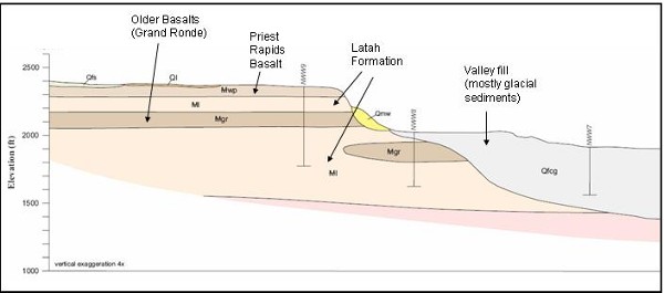
Above: The Stratigraphy near the bike trail
Your Earthcache Mission
The given coordinates bring you to the Lindeke Road Trailhead
(off 13th Ave.). Park near the trailhead sign and begin
your bike trek southwards, which is a slight uphill grade (all the
way to the Scribner Rd Trailhead if you decide to ride that
far). After Part 1 of this earthcache, you'll continue south
to the next waypoint and do Part 2. There are several ways to
approach this earthcache, so various trailhead coordinates will be
posted on this listing. As of this posting, there are at
least 3 geocaches that can be found along this trail segment for
your added fun!
The first set of coordinates will bring you to an exposure of
the Latah Formation. Here you will see light white-brown flat
rocks in the trail. Park your bike and do the following.
Part 1 "Latah" Coordinates: N 47 37.722 W
117 26.739
1. Pick up some of these light colored rocks and inspect
them for fossils. If you find a fossil, take a picture and
post it on your "found it" log. If you know
what type of leaf or plant or insect you find, post this info in
your log. NOTE: Do not climb the steep railroad
cuts as they are very fragile and could be dangerous if you should
fall. There are plenty of fossil-bearing rocks laying by the
trail. Do not take the fossils home - please leave them for
others to find.

A Latah Fossil
Part 2 "The Priest" Coordinates: N 47 35.591 W
117 27.127
The second set of coordinates for this earthcache will bring you
to a spot where the Priest Rapids Basalt encountered the sediments
of the Latah Formation. Here you will see pillow basalts up
close and personal. (They kind of remind me of big dinosaur
egg fossils.) You will need to do two things here:
1. Take a picture of yourself holding your GPS with the
pillows in the background.
2. Offer an explanation as to why the basalt is round and
not layered as is the basalt immediately above the pillows.
3. Bonus Question: Do you see holes in the center of some
of the pillows? Why/how do you think they formed?
Please do not post your answers to Part 2 in your cache log -
email them to me. But do post the required photos, fossil
info for Part 1, and anything else you discovered along the
way. If you bike this from the Lindeke Road Trailhead, it's
about a 6 mile round trip. The trail is gravel and dirt
paths, so mountain bikes are recommended. Hope you enjoy your
ride through time.

The Pillow Basalts