David E. Jackson is known for opening the Oregon Trail. Jackson
Hole, Wyoming was named for him.
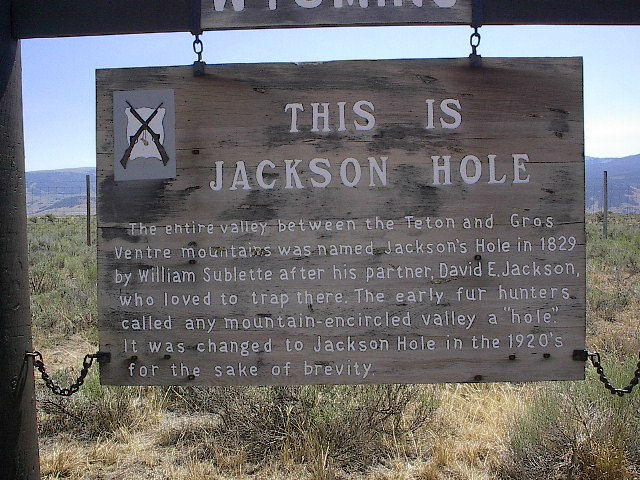
Jackson Hole is a valley located in the west-central U.S. state of
Wyoming. The name "hole" derives from language used by early
trappers or mountain men, who primarily entered the valley from the
north and east and had to descend along relatively steep slopes,
giving the sensation of entering a hole. These low-lying valleys
surrounded by mountains contain rivers and streams, good habitat
for beaver and other fur-bearing animals.
In 1810, John Jacob Astor outfitted an expedition (known popularly
as the Astor Expedition or Astorians) to find an overland supply
route for establishing a fur trading post at the mouth of the
Columbia River at Fort Astoria.
The expedition veered south of the Lewis and Clark route in what is
now South Dakota. In the process they passed through what is now
Wyoming, and stumbled upon South Pass: a wide, low pass through the
Rockies. Then they continued down the Snake River to the Columbia
River.
In what was dubbed "The Great Migration of 1843" or the "Wagon
Train of 1843", an estimated 1000 immigrants, led by Marcus
Whitman, arrived in the Willamette Valley. Hundreds of thousands
more followed, especially after gold was discovered in California
in 1848. The trail was still in use during the Civil War, but
traffic declined after 1869 when the transcontinental railroad was
completed. The trail continued to be used into the 1890s, and
modern highways eventually paralleled large portions of the trail,
including U.S. Highway 26 which follows the trail for much of its
length.
In the 20 years from 1840-1859 some 52,000 emigrants moved to
Oregon, but nearly five times that number opted for California or
Utah.
You won't find the trek to this little two stager near as difficult
as the pioneers had it. Proceed to the posted coordinates, where
you will find the marker for Eld. David Jackson. Beside Mr.
Jackson, you find another Jackson, who was PFC in the U.S. Army
during World War I. Answer this question for the coordinates to
Stage II:

What was PFC Jackson's first name?
A. Precious...N32° 04.817 W96° 17.728
B. Starling....N32° 04.828 W96° 17.717
C. Darling.....N32° 04.797 W96° 17.684
The cache is a small pill bottle, nestled down in a safe spot.
Corrdinates were a bit iffy here, even with 2 GPSr, and multiple
readings. So just be aware that this is not a tricky hide, it is in
a tree, on the fenceline. Hiding spots are somewhat limited here,
so it should be an easy find even though, hopefully, it's not
completely visible. While hiding this cache, there was the
prettiest, bright green snake (18"-24") climbing around the tree
next to the cache and then winding itself through the fence. This
tree had a old drink can wedged in it, and it's not the cache tree.
Also there is PI all around most of the trees, but it was not
around the tree where the cache is at the time of placement in late
summer. Coordinates have been corrected, thanks to the FTF crew
for making it right