Finger Lakes Geology: Cayuga Lake
 Finger Lakes Facts:
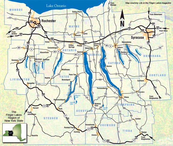
The Finger Lakes consist of 11 long, narrow, roughly parallel
lakes, oriented north-south. They lie within an imaginary triangle
between Syracuse, Rochester and Elmira-Corning. From west to east,
the 11 Finger Lakes are Conesus, Hemlock, Canadice, Honeoye,
Canandaigua, Keuka, Seneca, Cayuga, Owasco, Skaneateles, and
Otisco. Two of the lakes (Seneca and Cayuga) are among the deepest
in North America and have bottoms below sea level. These lakes all
formed over the last two million years by glacial carving of old
stream valleys.
Stewart Park in Ithaca is located at the south end of Cayuga
Lake. Cayuga is the longest and the second deepest of the Finger
Lakes at 38 miles long and 435 feet deep. The bottom of the lake is
53 feet below sea level at its deepest spot. The actual depth of
carved rock is well over twice as deep, but it has been filled with
sediments; there may be as much as 1000 feet of glacial sediment in
the deep rock trough below the lakebed.
Finger Lakes Lore:
One look from above and it's easy to see why the Finger Lakes
Region of upstate New York deserves its name. Each of the long,
slender bodies of water forms a striking resemblance to the fingers
of a hand. According to Iroquois legend, the lakes are the divine
handprints of the Great Spirit. In blessing the land, the spirit's
outstretched hands were placed over the region leaving each
finger-shaped impression. The hollows that were left quickly filled
with crystal-clear water forming the Finger Lakes.

Geologic Formation:
The Finger Lakes originated as a series of south-flowing rivers
that existed in what is now central New York State. Around two
million years ago the first of numerous continental glaciers
advanced southward, initiating the Pleistocene glaciation, commonly
known as the "Ice age."
The "Ice age" was really a series of many advances and retreats
of glaciers. The latest glacial episode was most extensive around
21,000 years ago, when glaciers covered almost the entire state.
Around 19,000 years ago, the climate warmed, and the glacier began
to retreat, disappearing entirely from New York for the last time
around 11,000 years ago.
The Finger Lakes were carved by several of these episodes of
glacial scouring. Ice sheets more than two miles thick flowed
southward, gouging deep trenches into these river valleys. Whereas
streams only erode as far down as sea level, glaciers are able to
erode more deeply. The bottoms of two of the Finger Lakes (Lakes
Seneca and Cayuga) are actually below sea level.
In additon, as the glaciers advanced, they pushed great
quantities of soil and rock ahead of them, like giant, slow-moving
conveyor belts. When the ice sheets began to melt and retreat, they
left these vast deposits of material behind. This glacial till
material dammed the stream valleys at their southern end. The
valleys then flooded to form the Finger Lakes.
Accumulations of glacial debris are called moraines, and the
piles left at the end (or snout) of a glacier are called terminal
moraines. Before the most recent ice age, many streams of the
Inland Basin region (especially in New York and Pennsylvania)
flowed south into the Susquehanna River. However, the Valley Heads
Moraine, blocked the flow of water to the south, damming the Finger
Lakes and forcing streams to drain north into the St. Lawrence
River Valley

To Log this Earthcache you need to complete the following
task:
- Take a photo of yourself with your GPS at the posted
coordinates with the lake in the background.
- In your log, post your photo.
- Send me an e-mail with the answer to the following
questions:
(1) What is unique about the depth of Cayuga Lake and what made
that depth possible?
(2) What direction does the water in the lake flow, and
why?
Sources:
Finger Lakes Geology
visit
link
Geology of New York, Y.W. Isachen, E. Landing, J.M. Lauber, L.V.
Rickard, W.B. Rogers, editors
Roadside Geology of New York, Bradford B. Van Diver
Overview of New York Geology
visit link
Museum of the Earth at PRI
Cayuga Waterfront Trail History
visit
link
Geology.com