The Natural Bridge Cavern is operated as a commercial attraction and requires a fee for entrance. The Caverns are open daily from 10am - 5pm - March through November. They are closed the rest of the year. Entrance to the caverns is on a guided tour offered at various times during the listed hours. Depending on how busy they are they usually offer between four to ten tours a day. Please call ahead at (800) 533-1410 to make sure you can arrive close to the start of a tour. Upon arrival you will need to register for the next available tour at the desk. The tour requires some physically demanding walking, descending, and climbing of stairs. Cavern temperature is 54 degrees. Jackets are recommended and non-skid shoes required.
Caves form in many different ways. Some are found in lava flows where the molten lava has moved out from underneath the cooling crust. Many small caves form along coasts as a result of dissolution and erosion by sea water and waves. Natural Bridge Caverns, like most, are formed by the dissolution of rocks such as limestone in waters moving underground.
Both limestone (calcium carbonate) and dolomite (contains magnesium as well as calcium) are slightly soluble in water, similar to the way salt dissolves in water. When the water contains carbon dioxide it forms a weak acid, called carbonic acid. The addition of carbon dioxide greatly increases the solubility. A small amount of carbon dioxide is found in rainwater and it picks up even more as ground water when it infiltrates through the soil. It picks up this additional carbon dioxide from decaying organic matter and plants. In this way the water passing through the soil and into the underlying rocks has the capacity to dissolve limestone and dolomite.
Many of the rocks in the area are layered and there are many cracks and fractures in them. Ground water trickling through the soil moves into and along these cracks. The ground water begins to dissolve the surface of the rocks exposed through these cracks. It is through this slow process that passages and large caverns are made. Water must continue moving through these underground passages for an extremely long time to make some of the large passages and rooms you will see here. Water moving through soluble rock will continue to dissolve it until the water becomes saturated with calcium and carbonate ions.
Eventually these solution cavities grow until the unsupported ground surface collapses forming a sink hole. Sink holes act as giant funnels greatly increasing the amount of ground water entering the underground system. Sometimes surface streams are diverted underground through openings known as swallow holes. It is possible for entire rivers to enter the solution passages in this way. A small sink is located on the top of Buck Hill and a collapsed portion of this formed the original entrance to the caverns. All water infiltrating the ground moves rapidly downward until all passages and cracks are filled at a saturation point know as the water table. Water below the top of the water table continues to circulate but it is much slower moving than through the cracks and spaces above it. Finally this water will reappear at a lower elevation on the ground surface, in this case, at Cedar Creek.
While the initial part of cave development takes place below the water table this only accounts for the passageways and rooms. Eventually the water table dropped as a result of the downcutting of Cedar Creek. Long ago Cedar Creek was as high as the top of the Natural Bridge and at that time the caverns were entirely filled with water. Over the years Cedar Creek cut its valley down to the where it is today and the caverns drained. After the water table drops to a point where the cave is filled with air instead of water the amazing cave deposits you will see begin to form.
In limestone caves, cave formations, called speleothems, are composed primarily of calcium carbonate, the mineral calcite. Calcite is deposited by groundwater saturated with the calcium and carbonate ions. In cave this is mainly the result of the loss of carbon dioxide into the air. Saturation may also take place when the water evaporates. Despite the same chemical process responsible for these formations, they tend to vary greatly. These variations depend on how the water enters, where it flows, the rate of flow, and the rate of deposition of the minerals.
Here's the chemical formula representing the dissolved mineral calcite precipitating out of the water:
Ca(HCO3)2 --> CaCO3 + H2O + CO2
This can also be represented as:
calcium bicarbonate --> calcite + water + carbon dioxide.
Straw or cone-shaped projections forming from the ceiling are called "soda straws." These tend to start as a single drop of water on the ceiling usually originating from a low point or fracture. As the drop of water hangs from the ceiling, it loses some of its carbon dioxide. This makes it less acidic. That means that it can't hold all of the dissolved minerals that it had picked up, on its way through the cracks above. The solution becomes saturated with calcium carbonate, and a small ring of the mineral is deposited. As this process repeats over time, the ring grows to become a small straw-shaped feature. This straw continues to grow until the inside is filled or the tip is covered. Once the hole in the straw is covered the feature is called a stalactite. It will still continue to grow as the saturated water flows down the outside of the formation giving it a cone shape.
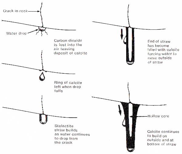
The drops that have fallen from these features are still not done creating cave formations. As the drops fall from the tip of the stalactite fall to the floor additional carbon dioxide is lost and a sister deposit is formed where it lands. This deposit is usually shaped like a small stump. These features growing up from the floor are called stalagmites. If this process continues for long enough these two formations will meet and form a column. Columns provide support for the roof of the cave.
A couple of other formations seen here are helicitites, flowstone, and drapery-shaped deposits. Helicitites are much like stalactites but seem to defy gravity by growing outward from cave walls, as water flows along small capillary sized openings, usually in very odd formations. Flowstone is the name given to deposits of calcite formed where water flows down the walls of a cave. The deposits are sheetlike and often exhibit larger crystals of calcite. Drapery-shaped deposits form when drops of water run down a sloping ceiling leaving an elongated curved deposit of calcite. While these are still thin enough to allow light to pass through they are called "bacon."
To claim this as a find:
1. What causes the green color seen on some of the formations?
2. What is the rate of growth of the flowstone cascade?
3. How far below the ground surface are you at the lowest point?
4. How deep is the water in Mirror Lake?
5. Why would going into Mirror Lake be a mistake?
6. Why is the section by Mirror Lake closed off?
7. Take a photo of yourself at your favorite formation along the way. (Optional but appreciated)
8. Take a photo of yourself with Mirror Lake in the background. (Optional but appreciated)
E-mail the answers (numbers 1-6) to me within a few days of your log.
Failure to comply with these requirements will result in log deletion.
Good luck and good caching.
- Rev Mike