Kinniconick Creek is a stream in Lewis County that winds it’s
way across just one county. It is said to be 99.9 miles long, just
shy of the 100 mile requirement that would make it a river. It can
be tranquil and it can be mean. The surrounding hills average
1,000‘ in elevation. The drainage basin can fill up quickly due to
the relief of it’s watershed. Flash Floods have wreaked havoc along
it’s shoreline during heavy rain events, but during most summer
months, it’s as gentle as can be.
Geologic researchers say that Kinniconick may have once been the
bed of an ancient river that connected with the Scioto River which
empties into the Ohio River at Portsmouth. If one looks at the rock
cliffs along the creek near Garrison (at its mouth), it can
immediately be seen that at one time the stream flowed much wider
and deeper than it does now. This would mean, according to
geologists, that Lower Kinney was once a part of a river that
existed before the Ohio River came into existence after the melting
of the glacier at the end of the Ice Age.
Researchers from Dennison University have studied the ancient
river course suggested. Their studies show that as the Ohio River
Valley widens perceptibly as it approaches the mouth of Kinniconick
Creek. Here the Ohio Valley is over a mile and a half wide. The
Ohio valley immediately above Portsmouth is scarcely a mile wide.
Kinniconick meets the Ohio from the south west flowing in the
opposite direction to that of the Ohio, on a direct course toward
the present day Scioto River bed. Some evidence suggests the
ancient river may have passed up the present day Ohio River Valley
toward Portsmouth. Because the valley of the Ohio seems to be
directly continuous with that of the Scioto, and the Scioto Valley
at its mouth is some wider than the Ohio immediately above
Portsmouth, a much larger watercourse turned north at the Scioto
River Valley. The volume of the waters in the Ohio above the mouth
of the Scioto and the latter stream, and the form, size and
directions of the valleys tell researchers that the Scioto could be
taken as the continuation of the Ohio Valley as it is seen
approaching the junction of these streams both from the Scioto and
lower Ohio Valleys. The bold cliffs of Waverly Shale and Sandstone
face the stream on both sides of the valley suggest where a much
wider ancient river once flowed.
Local residents are rightfully proud of this pristine stream
because of its beauty and relatively natural and pure condition.
It’s color is emerald green due to the rich minerals it carries
from the surrounding area. It is relatively unpolluted from
chemical waste because there are no towns or industries located
along its banks, or its small tributaries, and very little organic
or raw sewage is dumped into the stream, except the run-off from a
few sawmills and cattle feeding lots. Some say it is equal in
beauty to any of the state's natural bridges, caves, and forests
that have been set aside as parks and scenic areas to be
perpetually preserved.
The stream flows through a number of small communities and the
residents who live along its banks generally break it down
geographically into three sections: Upper Kinney, Middle Kinney and
Lower Kinney. What does the name, Kinniconick, mean? Some say it is
a Shawnee word that meant "willow bark", and indeed there are many
willows that drape themselves over the stream all along its banks.
Others contend that it means something like falling water, and
surely there are many rapids with "falling water" throughout the
length of the stream.
The stream begins its journey on the side of a hill near the
Lewis-Fleming County line at a height around 1,200 to 1,300 feet
above sea level and winds and twists for almost one hundred miles
until it empties into the Ohio River at Garrison at approximately
500 feet above sea level. Thus, in its course, it falls
approximately 700 feet or more. At its head, one can look into the
distance and see the high Cumberland Mountain peaks known as Long
Knob and Sugar Loaf Mountain, in Fleming County. As Kinniconick
flows through the hills it often gives the appearance of trying to
dodge smaller streams because it moves so close to them.
The head of Kinniconick and its general area has been a favorite
hunting spot for silver deposits. Time and again various persons
have claimed they had found silver deposits and some persons have
invested much time and effort in digging for silver at different
points along the stream. Near the mouth of Indian Creek, Kinney is
about 720 feet above sea level and thus has dropped about 480 feet
since it started on the dividing ridge of Fleming and Lewis. It is
understandable that Kinney can appear in a rage when the heavy
spring rains come because it is dropping fast. This also explains
the reason for its rapid settlement back to normal depth after
heavy rains. Indian Creek and its tributaries join forces with
Kinney and give it quite a boost because these streams have a much
larger combined watershed than does Kinney at this point. As
Kinniconick flows on eastward from the mouth of Indian, its mood
changes. It appears deeper with longer stretches of clear, shady
pools.
Below Indian Creek the stream makes a huge U-bend at where the
historic village of Kinniconick once was located.. This is the
closest that Kinney comes to the Ohio River until it flows many
more miles to the southeast and finally makes its determined plunge
to the northeast. The creek at the village of Kinniconick is about
680 feet above sea level, while the Ohio River, only six miles
distant, and almost parallel, is about 500 feet above sea level,
but a range of hills about 1,100 feet high separate the two
streams, one of these being the Vanceburg Hill.
From Pine Hill and Stafford Hill, one can look down on some of
the most picturesque scenes in the county, where the creek embraces
well tended farmlands and is graced along its banks with pines and
oaks. Fertile bottom lands have been formed here by alluvial soil
from the confluence of several streams such as Mill Branch, Rock
Run, Town Branch, Wolf Creek, Laurel Fork and its tributary Scott's
Branch. All empty into Kinney near Camp Dix. At this point, the
creek is between 550 and 560 feet above sea level and thus has
fallen a height of about 130 feet since it flowed past the village
of Kinniconick.
Between this point and the mouth of McDowell Creek, Kinniconick
becomes very much like a small river, yet it still has the
occasional riffle, and the scenery in places is breathtakingly
beautiful and quite unspoiled. The last large stream to flow into
Kinniconick is Montgomery Creek, This stream starts on the
Greenup-Lewis County line.
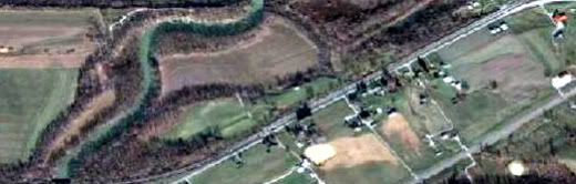
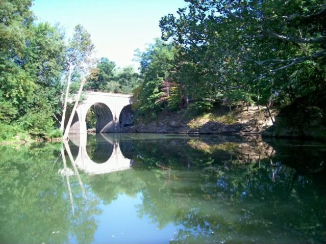
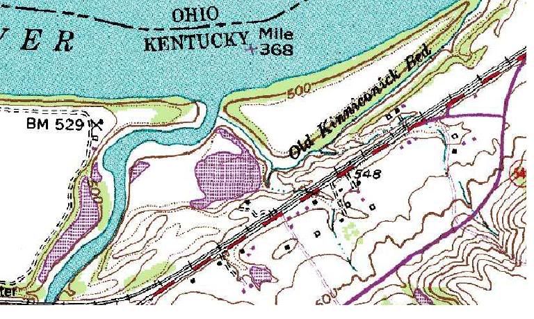
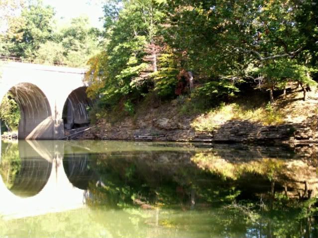
The present day town of Garrison is situated at the present day
mouth of Kinniconick The old mouth of Kinniconick Creek was
originally about half way between Garrison and Quincy. It was
created on the night of March 5, 1939, when a flash flood on
Kinniconick came down with such force that it cut through the wall
of the original silt peninsula (or natural levee) and left the old
bed empty and dry. The old and new beds are clearly visible from
satellite photos.
Through the centuries the silt washing out from the creek built
up an island in the river which the first settlers called Willow
Island. This island no longer exists now that the river pool has
been raised by the system of locks and dams, the water covering it
completely.
To visit the earth cache, travel Kentucky Route #8 to Garrison
Kentucky to the city public boat launch.
Answer the questions below and email us the answers, and take a
picture to post with your log.
1. Estimate the distance to the rock ledge at the bend in the
creek from the coordinates provided for the boat launch.
a. 100’ b. 300’ c. 500’
2. Take an elevation reading from the coordinates at the ramp to
show how far the elevation along the creek has fall from it’s
headwaters in the hills.
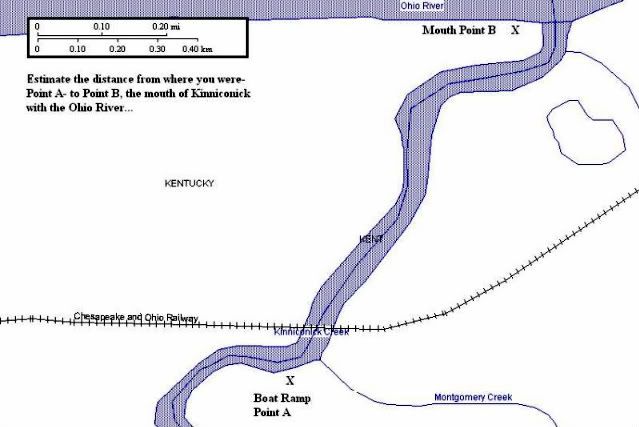
3. Using the map and legend below, estimate the distance from
the boat launch you visited to the mouth of Kinniconick at the Ohio
River.
Journey to Kinniconick and see this geologically and
historically famous creek. It is unique in many ways and deserves
attention from environmentalists and the citizens in order to
preserve its natural, unspoiled beauty so that it may be delivered
to posterity unmarred and unpolluted as it still is today.