The Fire Finder's Stump Traditional Cache
-
Difficulty:
-

-
Terrain:
-

Size:  (regular)
Please note Use of geocaching.com services is subject to the terms and conditions
in our disclaimer.
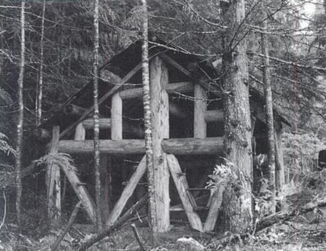 Built by the Forest Service in 1940, the Dan
Creek Guard Station was a log shelter built on a bench east of
Dan Creek. Abandoned in 1944, the structure was still in place
in the 1980s, although the most recent photo I found is from
1979. Of interest to me when researching the station's history
was that there was a stump about 50 feet behind the shelter
that the firefinder fit into the top of.
Built by the Forest Service in 1940, the Dan
Creek Guard Station was a log shelter built on a bench east of
Dan Creek. Abandoned in 1944, the structure was still in place
in the 1980s, although the most recent photo I found is from
1979. Of interest to me when researching the station's history
was that there was a stump about 50 feet behind the shelter
that the firefinder fit into the top of.
When we visited, we took the road as far as we could, which brought
us to about a quarter mile away from our destination. From there,
we walked the old road which is in sorry shape with trees down
across it and many young trees growing in it. About 400' (give or
take) from our destination, we entered a small clearing where we
lost anything that remotely looked like a trail. From there on in,
it was a bushwhack.
Although it is entirely possible that we missed it (at times, I
have been unable to find the broadside of a red barn in the
woods!), I believe this piece of lookout history has finally
succumbed to the elements. We found precious little, but there were
what looked like moss covered logs here and there, some with
angle-cut ends. Without the structure to guide us, it is impossible
to tell where "50 feet directly behind the shelter" was, but there
was a dandy stump that caught my interest and imagination. So
that's where this cache is.
About this cache:
- Although not absolutely needed, I would suggest a higher
clearance vehicle for the trip to parking. There is a fair amount
of vegetation growing in the center of the dirt roads towards the
end of your drive. My Highlander did fine.
- As of the day I hid this cache, access to the area was only
from NF24 (Dan Creek Road) to the northeast of Darrington. However,
the White Chuck Bench bridge replacement was nearing completion,
and may very well be finished by the time this cache is published.
Check with the Darrington Ranger Station for more information.
- The final road in may not be on your maps and is accessed from
NF2430 at about N48 14.318, W121 29.765. We parked and walked from
about N48 14.300, W121 30.334.
- You are looking for a Lock 'n' Lock type of container. There is
no need to start down the hill to search for the cache.
Finally, please let me know if there are problems with either the
cache or coordinates. Most importantly, have fun!
 texts
texts
Additional Hints
(Decrypt)
Ybbx sbe gur trbcvyr orgjrra n avpr fghzc naq gur gjb fznyyre gerrf gung tebj evtug arkg gb vg.