Ohio & Kentucky River Confluence EarthCache
Ohio & Kentucky River Confluence
-
Difficulty:
-

-
Terrain:
-
Size:  (other)
Please note Use of geocaching.com services is subject to the terms and conditions
in our disclaimer.
The cache coordinates take you to a Point Park located in Carrollton Kentucky.
While geocaching in the area, seeing all the historical markers / plaques honoring citizens in and around the park and the City of Carrollton as well as my love of earthcaches, I wanted to show my appreciation by creating this earthcache. Point park is used for many events because of the history and location of both the Kentucky River and Ohio River.
The confluence is the only major river confluence located between Markland Locks / Dam and Mcalpine Locks / Dams. This strech of river is approxmately 75.3 miles long and on average the Ohio River is .4 miles wide. The river is controlled by the lockand dams mainly for river commerece so barges can move goods up and down river.
CONFLUENCE
 Ohio & Kentucky River Confluence
Confluence, in geography, describes the meeting of two or more bodies of water.
It usually refers to the point where a tributary joins a more major river.
A notable confluence is the merging of the Ohio and the Kentucky Rivers. Then the Ohio meets the Mississippi for another notable confluence.
The confluence of the Ohio and Kentucky Rivers is not as big, but by definition is the same as the confluences described above.
RIVER
A large natural stream of water (larger than a creek).
A river is a large natural waterway. It is a specific term in the vernacular for large streams, stream being the umbrella term used in the scientific community for all flowing natural waterways. In the vernacular, stream may be used to refer to smaller streams, as may creek, run, fork, etc.
A River starts at a point called its source, and enters a sea or lake at its Mouth.
Along its length it may be joined by smaller rivers called tributaries; A river and its tributaries are contained within a drainage basin called the watershed.
The point at which two or more rivers join, is called the Confluence.
OHIO RIVER
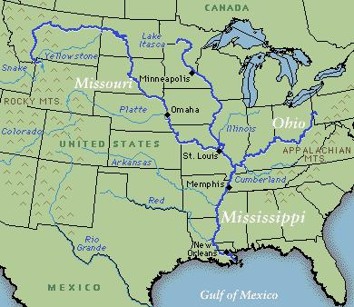
The Ohio River is the largest tributary by volume of the Mississippi River.
It is approximately 981 miles (1,579 km) long and is located in the eastern United States.
The river had great significance in the history of the Native Americans.
It was a primary transportation route during the westward expansion of the early U.S.
It flows through or along the border of six states, and its drainage basin encompasses 14 states,
including many of the states of the southeastern U.S. through its largest tributary, the Tennessee River. During the nineteenth century, it was the southern boundary of the Northwest Territory, thus serving as the border between free and slave territory. It is sometimes referred to as the "Mason-Dixon line" as it is commonly acknowledged as the western natural extension of the original Mason-Dixon line that divided Pennsylvania and Delaware from Maryland and West Virginia (then a part of Virginia) thus being the unofficial, and at times disputed, border between the Northern United States and the American South or upland South. The Ohio River is a climatic transition area as its water runs along the periphery of the humid subtropical climate and humid continental climate thereby being inhabited by fauna and flora of both climates. In his Notes on the State of Virginia published in 1781-82, Thomas Jefferson stated: "The Ohio is the most beautiful river on earth. Its current gentle, waters clear, and bosom smooth and unbroken by rocks and rapids. The river is formed by the confluence of the Allegheny and Monongahela rivers at Point State Park in Pittsburgh, Pennsylvania. From Pittsburgh, it flows northwest through Allegheny and Beaver Counties, before making an abrupt turn to the south-southwest at the West Virginia-Ohio-Pennsylvania triple state line (near East Liverpool, Ohio, Chester, West Virginia, and Midland, Pennsylvania), from which point it forms the border between West Virginia and Ohio, upstream of Wheeling, West Virginia. The river then follows a roughly southwest and then west-northwest course before bending to a west-southwest course for most of its length. It flows along the borders of West Virginia, Ohio, Kentucky, Indiana, and Illinois, until it joins the Mississippi near the city of Cairo, Illinois.
KENTUCKY RIVER
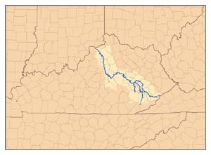 Map of the watershed of the Kentucky River, showing the North Fork, Middle Fork, and South Fork tributaries.
The Kentucky River is a tributary of the Ohio River, 259 mi (417 km) long, in the U.S. state of Kentucky. The river and its tributaries drain much of the central region of the state, with its upper course passing through the coal-mining regions of the Cumberland Mountains, and its lower course passing through the Bluegrass region in the north central part of the state. Its watershed encompasses about 7,000 sq. mi (18,000 km). It supplies drinking water to about one-sixth of the population of the state. The river is no longer navigable above Lock 4 at Frankfort, KY. Concrete bulkheads have been poured behind the upper lock gates of Locks 5-14 to strengthen the weakest link in the dam structures. All 14 dams are now under the management of the state-run Kentucky River Authority. The primary importance of the locks today is to maintain a pool that allows the city of Lexington to draw its drinking water from the river. It is formed in eastern Kentucky at Beattyville, in Lee County, by the confluence of the North, Middle and South Forks at about 670 feet (204 m) elevation, and flows generally northwest, in a highly meandering course through the mountains, through the Daniel Boone National Forest, then past Irvine and Boonesborough, then southwest, passing south of Lexington, then north through Frankfort. It joins the Ohio at Carrollton.
You will need to go to the posted coordinates, answers the questions below and take two pictures.
1. What is the flow of the Ohio River up stream from the confluence?
2. What is the flow of the Kentucky River up stream from the confluence?
3. What is the definition of a confluence?
4. Estimate the distance across the Ohio River?
5. Estimate the distance across the Kentucky River?
6. Take a picture with your gps, in which your face is identifiable and I can see the Confluence in the background, then post it with your log.
7. There is a large rock with a plaque near the coordinates honoring Dr Harry J Flotemersch D.V.M. take a picture with your gps, in which your face is identifiable and I can see the Rock in the background, then post it with your log.
TO CLAIM THIS AS A FIND: Email me your answers and post your pictures at time of logging. Logs submitted without the answers and pictures posted WILL BE DELETED by owner!
THIS EARTHCACHE WAS PLACED BY A
PLATINUM EARTHCACHE MASTER
Additional Hints
(Decrypt)
UNIR SHA