Fort Sherman EarthCache
Please note Use of geocaching.com services is subject to the terms and conditions
in our disclaimer.
This is a five point multi-earthcache and will include a history lesson in addition to a geological lesson. A BIG THANK YOU goes out to GeoAware for allowing both. The first four points make up the history lesson with the final point being your geological lesson for the day. Ready here we go.....
While on an inspection tour in 1877, General William Tecumseh Sherman camped by Coeur d'Alene Lake at the mouth of the Spokane River and was so impressed by the scenery of the area that he recommended it as a site for a fort.
Sherman's recommendation received attention the following year, and on April 16, 1878, a military post known as Camp Coeur d'Alene was established. The name was changed to Fort Coeur d'Alene on April 5, 1879, and finally to Fort Sherman, April 6, 1887. Supplies reached the new post by steamboat on the Columbia and Snake Rivers to Texas Landing and thence by wagon route via Spokane Bridge, Washington Territory. This latter point, situated ten and a half miles from the post, was the nearest post office location for the new installation.
Camp Coeur d'Alene had three reasons for its existence: (1) keeping the peace in northern Idaho, (2) protecting railroad and telegraph crews, and (3) guarding the border with Canada. The first two objectives occupied the troops most of the time, as there were few problems on the northern border.
Troops stationed at the post must have found it in some ways an ideal duty station, because they were seldom called upon to take the field against threatening forces. In fact, only twice were they summoned to protect the interests of North Idaho citizens. On July 12, 1878, the troops took the field to participate in the Bannock Indian War. However, the extent of their involvement turned out to be only a hurried march to Fort Lapwai as they were back at their duty stations on August 1. (The Bannock campaign never got even close to North Idaho.) During the Coeur d'Alene mining troubles of 1892, the troops received a call to restore order. The soldiers, under the command of Colonel William P. Carlin, left the fort on July 12, 1892. They were equipped in heavy marching gear which consisted of eight rations and 100 rounds of ammunition per man. They were transported on the Northern Pacific Railroad Company's steamer to Harrison and thence by rail to Wardner. At this point a command post was established. Upon arrival the troops aided the civil authorities in making arrests and preserving martial law. In September of 1892, sub-posts were created at Wallace, Burke, Gem, and Wardner, under the command of Lt. Colonel H. C. Cook, Fourth Infantry. The sub-posts were disbanded in November, 1892.
Many considered Fort Sherman to be one of the most scenic posts in the United States, but the soldiers stationed there sometimes took a dimmer view of the situation. The site was only five feet above the level of the lake, which periodically flooded the parade grounds. The floods caused numerous problems for the troops, as noted in the following remarks entered in the May 1894 monthly report:
"The water of the lake and river Coeur d'Alene continued rising during the month and on the 25th instant the dike protecting the post from the overflow of the river broke, and a great part of the reservation became submerged. The water continued to rise and on the same day the lake overflowed its banks and further inundated the post, only a narrow strip of ground on the parade and along the lake showing above the flood. Officers quarters except No's 5, 6, 7, and 18 being flooded from one to five feet deep, the guard house, hospital, storehouses and other public buildings being uninhabitable. Water surrounds all the company barracks. Obtaining good water for the fort also caused a problem from the beginning, and $7,000 had to be spent on a pump and pipe system."
The departure of the command on April 21, 1898, for participation in the Spanish-American War signaled the demise of the fort. A small detachment remained; but in April 1901, when the reservation was turned over to the Interior Department, they relocated at Fort George Wright, Washington. In the summer of 1905, the reservation was sold at public auction. Before selling the land, the government set aside twenty acres for a park and twenty acres for a cemetery as the property of the city of Coeur d'Alene. The Stack and Gibbs Lumber Company purchased a large share of the land. Much of the site today is occupied by the North Idaho College. Only a handful of the original 52 structures now remain.
The coordinates listed above are for waypoint #1 of this earth cache. They will take you to a man made terrain feature which you probably would not normally have paid any attention to. It is a large island median which separates the north and south bound lanes of the southern portion of Government Way. This median however was not made for its ascetic value as most are. In fact as history tells it the present day south bound lane of Government Way is actually the former U.S. Army road leading to Fort Sherman, from the Mullan Trail (which is now present day I-90). While the present day north bound lane of Government Way was the civilian road leading to the new little town of Coeur d'Alene. The army road was restricted to military travel only, thus the second road was made parallel to it forming the median we still see today. Forest Cemetery which is on Government near the coordinates was the army cemetery at the time. It was deeded to the City of Coeur d'Alene by the U.S. Government after the fort officially closed.
From the waypoint #1 coordinates for the median you answer the following question:
1) Now separated by cross streets, how many islands make up the total median down Government Way?
Waypoint #2 will take you to the original little red Fort Sherman chapel. From here answer the following question.
2) Besides a chapel, what else was this little red building used for?

Now onto waypoint #3, which will take you to one of the original officer’s quarter’s buildings from Fort Sherman. From here you need to answer the following question.
3) In what year was this officer’s quarters built?
Waypoint # 4 will take you around the corner to the brick powder magazine building. In front of it is a replica of the fort archway gate. During the summer months this little building is home of the Fort Sherman Museum. We were told it is only open during the summer months as there is no heat inside the building. From here please answer the following question.
4) How many windows are there on the Powder Magazine, counting them from all four sides of the building?

You will now need to travel to waypoint #5, the final point at the mouth of the Spokane River and your geological lesson for the day.
The Spokane River is a tributary of the Columbia River, approximately 111 miles (179 km) long, in northern Idaho and eastern Washington in the United States. It drains a low mountainous area east of the Columbia, passing through the city of Spokane, which shares its name with the river. Heavily used for irrigation and drinking water, its watershed comprises a region of extensive farming and timber production. The lowered water levels in the river have resulted in an ongoing pollution crisis and a political struggle over its resolution.
The Spokane River's entire drainage basin is about 6,240 square miles (16,200 km2) large, of which 3,840 square miles (9,900 km2) are above Post Falls Dam at the outlet of Coeur d'Alene Lake. Its mean annual discharge is 7,946 cubic feet per second (225 m³/s).
The Spokane River rises out of Lake Coeur d'Alene in the Idaho Panhandle, draining from the northwest corner of the lake near the city of Coeur d'Alene. It flows west approximately 25 mi (40 km) into east central Washington to Spokane, where it receives the Hangman River from the south.
From Spokane it flows northwest, receiving the Little Spokane River from the east approximately 10 mi northwest of the city. It flows in a zigzag course along the southern edge of the Selkirk Mountains, forming the southern boundary of the Spokane Indian Reservation, where it is impounded by the Little Falls Dam, and to form Long Lake, a 15 mi (24 km) reservoir. It joins Franklin D. Roosevelt Lake on the Columbia from the east at Miles. The site of historic Fort Spokane is located at the mouth of the river on the Columbia.
Much of the river's water, particularly during the summer, comes from underground springs fed by the Spokane-Rathdrum Aquifer. The aquifer provides drinking water for 400,000 people in the Spokane area, as well as extensive irrigation water along its course. The use of the aquifer water is so extensive that Spokane Falls, the signature natural feature of the city of Spokane, runs dry during many summers, with all the water being diverted to the Upper Falls and Lower Falls hydroelectric power plants. The lowered water levels have raised the toxicity of the stream, resulting in low concentrations of dissolved oxygen and algae blooms along much of the river's lower course.
In 2002 the Environmental Protection Agency issued a Superfund cleanup plan for the Spokane River-Lake Coeur d'Alene basin. In a controversial move, the Bush administration transferred control of the Idaho portion to the state of Idaho, which opposes the Superfund designation and the cleanup, partly based on its high cost and possible effect on real estate prices.
From your location at waypoint #5 please answer the following two questions:
5) What type of beach material is located at the mouth of the river? I.e. is it sandy, rocky, a little of both, etc?
6) What is the distance across the river from shore to shore at the mouth?
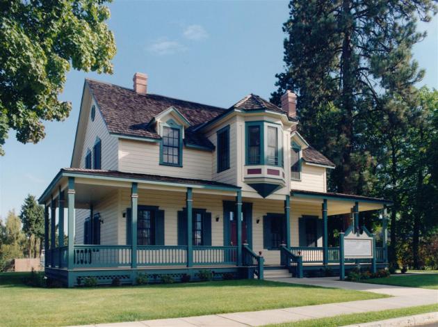
The Spokane River and Fort Sherman then.

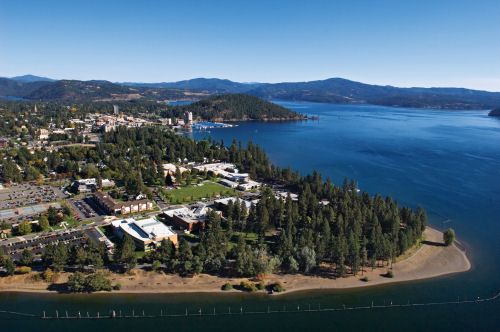
The Spokane River and North Idaho College now.
TO CLAIM THIS EARTHCACHE YOU MUST DO THE FOLLOWING OR YOU LOG MAY BE DELETED:
ANSWER ALL SIX QUESTIONS LISTED ABOVE. DO NOT POST THEM WITH YOUR LOG!! EMAIL YOUR ANSWERS TO MARTIN 5.
AND
POST YOUR PICTURE TAKEN AT THE BEACH AREA OF WAYPOINT #5 WITH YOUR LOG ENTRY.
We hope this earth cache will be fun and educational for all who take the time to do it. For those who may be physically unable to walk down to the beach for the Final, coordinates for a handicap parking area have been posted, where there is also a wheel chair ramp. This location can be used for question #5 and to take your beach picture if you can not physically get to the river location.
For more information on Coeur d'Alene Lake please refer to another earthcache: GC1AA9M.
For more information on the Rathdrum Prairie/Spokane Aquifer please refer to another earthcache: GC14NP3.
Have fun!!!


Martin 5
Platinum Earthcache Master
Congratulations to racknap for being the first to complete all of the logging requirement for this earthcache!!
This cache was Nominated Best Documentary (Earth Cache) for 2008 by our fellow cachers prior to the awards ceremony held at the 3rd Annual WSGA Winter Party -THINK SPRING! event. (GC1KT0Q)
Additional Hints
(No hints available.)
Treasures
You'll collect a digital Treasure from one of these collections when you find and log this geocache:

Loading Treasures