Markland Dam EarthCache
Please note Use of geocaching.com services is subject to the terms and conditions
in our disclaimer.
This Earthcache is located at: The Markland Dam Park, on Rt. 156.
This park provides picnic shelters, a play-ground, baseball fields, and access to fishing.
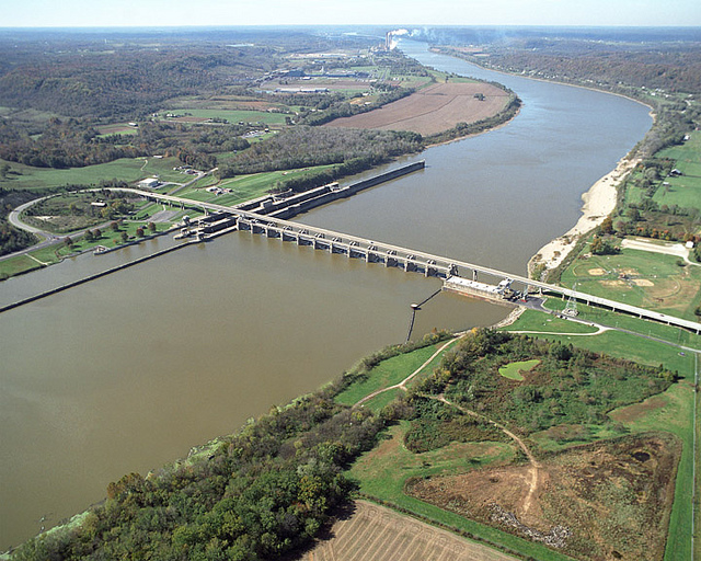
The Markland Locks and Dam is located on the Ohio River at mile 531.5 below Pittsburgh, Pennsylvania. It is 26 ½ miles upstream from Madison, Indiana and 3 ½ miles downstream from Warsaw, Kentucky. The navigation locks are located on the Kentucky side of the river . The upper pool above the dam extends upstream for a distance of 95.3 miles to the Meldahl Locks and Dam at mile 436.0 and for a short distance up three navigable tributaries--the Miami, Licking, and Little Miami Rivers
Prior to building the Markland Dam, the Ohio River was not as wide or deep as it is today. The river would freeze, allowing citizens of Rabbit Hash to walk across without getting wet. Ferryboats were also busy for many years in this area. The last one to serve those in Ghent, Ky., and Vevay was the Martha A. Graham, which ran from 1943 until 1978 when the Markland Dam Bridge was completed.
The replacement plan for Ohio River Locks and Dams No. 35, 36, 37, 38 and 39 by the Markland Locks and Dam was reviewed by the Board of Engineers for Rivers and Harbors and was approved by the Secretary of the Army on March 11, 1953, in accordance with the Rivers and Harbors Act approved March 3, 1909.
Under license granted by the Federal Power Commission, Duke Energy operates a hydroelectric power plant at Markland Dam. Capacity of the plant is 81,000 kva.
Markland Lock’s construction started in March 1956. The locks were placed in operation in May 1959. Dam construction started in April 1959 and was completed in June 1964.
The flood of 1937 nearly destroyed the Laughrey Club on Laughrey Island, The club was used for large parties and meetings also riverboats would stop at the island to drop off and pick up passengers. When the Markland Dam was opened in 1962 it sent Laughrey Island underwater along with the old Dam #38.
Markland Locks and Dam processed an average of 51.8 million tons of waterborne commerce annually from 2000 to 2005. Coal was the principal commodity at Markland representing 39% of the total. Electric utilities move coal from mines in Wyoming, Kentucky, Pennsylvania, and West Virginia to power plants serving the southeastern and Midwestern regions of the country. Iron and steel related commodities represent the second biggest commodity, roughly 14%, processed through Markland. Steel companies use Markland in transporting iron ore to steel mills in Kentucky and West Virginia, and aluminum companies move aluminum ores to smelters in Ohio and West Virginia. These and other shippers relying on Markland realized average annual transportation cost savings in excess of $588 million from 2000 to 2005 when compared to the next least cost method of transporting the goods.
The river stage is strongly affected by the Markland Dam; the normal pool elevation is approximately 455 feet above mean sea level between the dam and Cincinnati. Following storm events in the upper Ohio River drainage basin, the river gradient between Cincinnati and Markland Dam increases greatly. The dam is used to control the amount of flow downstream, so that the difference between the two gauges can be tens of feet. At low-flow times, the difference can be less than a foot.
There is also a park with an overlook on the Kentucky side. But from what I was told, Geocaches/Earthcaches are not allowed in that park. But it is a great place to watch the boats go through the locks.
Thanks for visiting, to get credit for this EarthCache please email me the answers to questions 1-4.
1. Estimate the length of the bridge over the dam. (In Feet)
2. Estimate how many feet from the water to the top of the Dam.
3. Estimate how many feet from the water to the bridge.
4. Describe how you think the area has been affected by this dam.
Please include in your online log:
A. A picture showing you and/or your GPS with the Dam in the background.
As always uploading pictures are optional, but they will help keep things interesting so if you are able to, please do so.
Additional Hints
(No hints available.)
Treasures
You'll collect a digital Treasure from one of these collections when you find and log this geocache:

Loading Treasures