
Geologist frequently create models of the landscapes they study in order to understand the forces at work and to better be able to explain their findings to others.
Whether done with a simple line drawing or a three-dimensional model, each line and symbol have meaning. Often seemingly simple diagrams convey complicated and rich details of the history of the area recorded in its rocks.
To claim this EarthCache:
Simply observe one of the basic principles of geology anywhere in the park. Go to the given coordinates and observe the details of the building facade. If necessary, read the directions below to learn about geologic symbols, terminology, and modeling.
Once you understand the concepts shown by the building, you are ready to complete the EarthCache:
- OPTIONAL Photograph yourself with your gps, admiring the unique architecture of the Interpretive Center (You do not have to show your face!) (The Interpretive center must be in view, but you can chose a more “artistic” location to stage your photo)
- Find an example of sedimentary layering, faulting, missing layers (disconformity), etc anywhere else in the park and photograph or describe that feature.
You or your gps should be in the view for scale.
- Tell us what the feature is on your online log
You don't even have to figure out how your feature would be signified on a block diagram or a geologic column (although Mrs A is offering extra credit for those who do try to figure out that information. Just like the points on “Whose Line is it Anyway” the points are made up as she goes along and they aren't worth anything, —but they are fun to collect!)
Some background information that may be helpful
When scientists began studying layers of rock, they agreed on some basic “principles” about how rocks form:
Law of original horizontality:
unless the area is disturbed, sedimentary rocks form in flat layers
Law of superposition:
The rocks on top are younger (newer) than those on the bottom.
Scientists can use those “laws” to study layers of rocks. The study of layers of rocks is called stratigraphy. It's very useful for comparing the ages of layers of rock to each other and for trying to learn what kinds of land-shaping events have taken place in an area.
Rocks don't always sit undisturbed, though. So scientist also developed some common sense “rules” about how to interpret rocks that have been disturbed:
Law of cross cutting relations:
If something cuts across a layer of rock, it has to be younger than the layer it cuts across.
Law of inclusion:
If there is an odd rock fragment in a layer of rock, the fragment has to be older than the layer of rock. It did not form inside the layer. The inclusion formed at an earlier time, and was on the surface when it was buried in the new layer.
Sometimes, the rock layers that ought to be there aren't. We know they ought to be because they are there in the same rocks somewhere else. Scientist learn a lot about what happened in a particular location from these missing rocks.
Special terms to know:
- disconformity - missing layers of rock due to erosion
- paraconformity- missing rocks that just never formed there (maybe a hill got in the way)
- angular unconformity – lower layers are at a different angle than higher layers (the ground is not at the same angle it was for the lower level).
- Non-conformities – rocks in the layers formed by different processes (Ex: lots of sedimentary rock layers like sandstone and limestone suddenly have a layer of volcanic rock and then more sedimetary rocks)
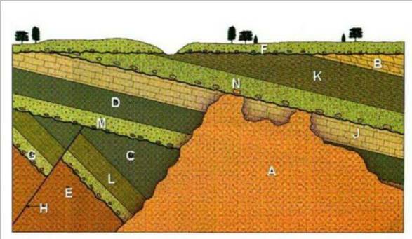
It's also very useful to visually record that information in a sketch, line drawing, or 3-D model.To show the different features, scientists provide keys to the symbols for various rock types:

Sand stone will have dots in it, limestone is shown by bricks or squares, angled bricks are dolostone, black rock is volcanic etc.
Below is a diagram that shows lots of these ideas:
It has layers of different strata showing horizontality and superposition.
It has a dike (volcanic layer) and a fault (place where the rock dropped or lifted due to earthquakes, usually) which shows cross-cutting relationships.
It even has inclusions!

Now look at the photograph of the Interpretive Center at the Falls of the Ohio again. What do you see?

Yes! It is a representation of a stratigraphic diagram! You'd be amazed how many people don't realize that until it is pointed out to them.
Now you that you've noticed, can you locate some of the layers of bedrock the building is supposed to represent?
If you need help, this page explains all these terms in simple ways with nice detail!): Geologic Time
And visit these links for more help:
Definitions and images to illustrate geological terms
student and parent help portal (Lots of Earth & Space help!)
Fossil and rock collecting is prohibited at the Falls of the Ohio
However, a local quarry donates 30 tons each of fossil-bearing Silurian Waldron shale and Devonian Jeffersonville Limestone for the fossils festival each year. The quarry piles are located in the back parking lot. Dig for brachiopods, bryozoans, corals, crinoids, cystoids, snails, clams, and trilobites in Hanson's Fossil Collecting Piles. Coordinates: N 38° 16.652 W 085° 45.847
This EarthCache was created by local high school students with permission and assistance from the Interpretive Rangers at the Falls of the Ohio State Park.
To learn more about the Falls of the Ohio State Park, go here: Educational Opportunities at the Falls of the Ohio