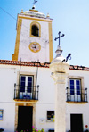
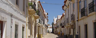
 O Alandroal é uma vila portuguesa pertencente ao Distrito de Évora, região do Alentejo e sub-região do Alentejo Central. Ergue-se a 341 m de altitude. A vila de Alandroal localiza-se na margem direita do rio Guadiana, a nordeste da cidade de Évora e a sudeste da cidade de Estremoz. O Alandroal é uma vila portuguesa pertencente ao Distrito de Évora, região do Alentejo e sub-região do Alentejo Central. Ergue-se a 341 m de altitude. A vila de Alandroal localiza-se na margem direita do rio Guadiana, a nordeste da cidade de Évora e a sudeste da cidade de Estremoz.
É sede de um município com 544,86 km⊃2; de área e 6585 habitantes (2001), subdividido em 6 freguesias (Nossa Senhora da Conceição, Santo António de Capelins, Nossa Senhora do Loreto, São Brás dos Matos, Santiago Maior e São Pedro). |
 Alandroal is a Portuguese town belonging to the district of Évora, region of the Alentejo and sub-region of the Alentejo Central. It raises up at about 1100ft of altitude. The town of Alandroal is placed in the right margin of the river Guadiana, northeast to Évora and southeadt to Estremoz. Alandroal is a Portuguese town belonging to the district of Évora, region of the Alentejo and sub-region of the Alentejo Central. It raises up at about 1100ft of altitude. The town of Alandroal is placed in the right margin of the river Guadiana, northeast to Évora and southeadt to Estremoz.
It is the seat of a town council with about 200 square miles and 6585 inhabitants (2001), subdivided into 6 parishes ((Nossa Senhora da Conceição, Santo António de Capelins, Nossa Senhora do Loreto, São Brás dos Matos, Santiago Maior and São Pedro). |
| Gastronomia local / Local gastronomy:
Ensopado de borrego, feijão com espinafres, favas de azeite, poejada, açorda de alho, beldroegas com queijo e filhós.
|
 O concelho de Arraiolos, com uma área de 684,08 Km2, tem uma população de 7616 habitantes (Censos 2001) e é constituído por sete Freguesias: Arraiolos, Igrejinha, Santa Justa, Sabugueiro, S. Gregório, S. Pedro da Gafanhoeira e Vimieiro. O concelho de Arraiolos, com uma área de 684,08 Km2, tem uma população de 7616 habitantes (Censos 2001) e é constituído por sete Freguesias: Arraiolos, Igrejinha, Santa Justa, Sabugueiro, S. Gregório, S. Pedro da Gafanhoeira e Vimieiro.
Arraiolos é um dos catorze concelhos do Distrito de Évora e tem os seus limites administrativos definidos desde 1736.
Com a Vila de Arraiolos situada a uma altitude de 348,50 m (Longitude 7º 59' W e Latitude 38º 43' N), o concelho confina a norte com os concelhos de Mora e Coruche, a Oeste com o concelho de Montemor-o-Novo, a Sul com o concelho de Évora e a Este com com os concelhos de Estremoz e Sousel.
Integrado quase na totalidade na bacia hidrográfica do Tejo, com as ribeiras de Divor e de Tera a constituírem os seus principais cursos de água, tem uma posição geográfica privilegiada, que lhe confere potencialidades turísticas acrescidas se se considerar todo o seu património natural, arquitectónico e artístico.
Arraiolos tem um clima de transição para características continentais atenuadas, em parte devido à inexistência de cadeias montanhosas e à relativa proximidade do mar. |
 The Municipality of Arraiolos, with an area of 265 square miles has a population of 7616 inhabitants (censuses 2001) and is constituted by seven parishes: Arraiolos, Igrejinha, Santa Justa, Sabugueiro, S. Gregório, S. Pedro da Gafanhoeira and Vimieiro. The Municipality of Arraiolos, with an area of 265 square miles has a population of 7616 inhabitants (censuses 2001) and is constituted by seven parishes: Arraiolos, Igrejinha, Santa Justa, Sabugueiro, S. Gregório, S. Pedro da Gafanhoeira and Vimieiro.
Arraiolos is one of the fourteen municipalities of the District of Évora and its administrative limits are defined since 1736.
With the Town of Arraiolos placed at an altitude of 110 feet (Longitude 7º 59' W and a Latitude of 38º 43' N), the municipality is limited north by the municipalities of Mora and Coruche, west with the municipality of Montemor-o-Novo, south with the municipality of Évora and east with the municipalities of Estremoz and Sousel.
Integrated almost in the river Tejo, with the brooks of Divor and Tera constituting its main water courses, has a privileged geographic position which provides it enlarged tourism potentialities if we consider all its natural, architectonic and artistic heritage.
Arraiolos has continental attenuated characteristics climate, partly die to the inexistence of mountains and to the relative proximity to the sea. |
Gastronomia local / Local gastronomy:
Os pratos de “porco”, de “borrego”, de “vitela”, as “sopas alentejanas”, as “açordas” e as “migas”.
|
 O concelho de Borba integra o distrito de Évora, região Alentejo e sub-região Alentejo Central. Com uma área de 144,9 km2, tem uma população de 7.785 habitantes, e está dividido em quatro freguesias: O concelho de Borba integra o distrito de Évora, região Alentejo e sub-região Alentejo Central. Com uma área de 144,9 km2, tem uma população de 7.785 habitantes, e está dividido em quatro freguesias:
- Matriz, freguesia mista (urbana/rural), com a área de 41,23 km⊃2;, tem 3.701 habitantes;
- São Bartolomeu, freguesia urbana, com a área de 0,14 km2, tem 932 habitantes.
- Rio de Moinhos, freguesia rural, com a área de 52,92 km2, tem 2,271 habitantes;
- Orada, freguesia rural, com área de 50,83 km2, tem 878 habitantes.
O concelho é limitado a nordeste pelo município de Monforte, a leste por Elvas, a sueste por Vila Viçosa, a sudoeste pelo Redondo e a oeste por Estremoz. A distância até à capital de distrito, Évora, é de 57 km’s, a Lisboa de 180 km’s, e à fronteira com Espanha de 42 km’s. A vila de Borba fica a uma altitude de 416 metros.
O clima é o do planalto alentejano, onde por vezes a temperatura chega a subir no Verão aos 40 graus centígrados, e a descer no Inverno abaixo de 0 graus. As temperaturas são muito extremas, para o que também concorre o facto da maior parte do concelho estar exposta aos ventos secos do nordeste. |
 The municipalityof Borba is a Portuguese town belonging to the district of Évora, region of the Alentejo and sub-region of the Alentejo Central.With an area of 144.9 km2, has a population of 7785 inhabitants, and is divided into four parishes: The municipalityof Borba is a Portuguese town belonging to the district of Évora, region of the Alentejo and sub-region of the Alentejo Central.With an area of 144.9 km2, has a population of 7785 inhabitants, and is divided into four parishes:
- Matriz, parish mixed (urban / rural), with the total area of 41.23 square kilometers, has 3701 inhabitants;
- St. Bartolomeu, urban parish, with the area of 0.14 km2, has a density of 932 inhabitants.
- Rio de Moinhos, rural parish in the area of 52.92 km2, has 2271 inhabitants;
- Orada, rural parish, with an area of 50.83 km2, has 878 inhabitants.
The municipalityis limited to the northeastern city of Monforte, east to Elvas, the southeast Vila Viçosa, Redondo, to the southwest and west to Estremoz. The distance to the capital district, Évora, is 57 km's, 180 km from Lisbon's, and the frontier with Spain's 42 km. The town of Borba is located at an altitude of 416 meters.
The climate of this part of Alentejo, where the temperature sometimes reaches up in the summer at 40 degrees centigrade, in winter and fall below 0 degrees. The temperatures are very extreme, which also contributes to the fact that most of the municipalitybeing exposed to dry winds from northeast. |
Gastronomia local / Local gastronomy:
Feijão com alabaças, grão com arrabaças, cação frito, burras assadas, azevias e nógados.
|
 O concelho de Estremoz insere-se numa região denominada por Zona dos Mármores. Este concelho ocupa uma área total de 514 Km2 e tem uma população de 15 657 habitantes. O concelho de Estremoz insere-se numa região denominada por Zona dos Mármores. Este concelho ocupa uma área total de 514 Km2 e tem uma população de 15 657 habitantes.
É constituído por 13 freguesias, sendo que duas são urbanas – Santo André e Santa Maria – e as onze restantes são rurais: Arcos, Évoramonte, Glória, S. Bento do Ameixial, S. Bento do Cortiço, S. Bento de Ana Loura, S. Domingos de Ana Loura, Santo Estevão, S. Lourenço de Mamporcão, Veiros e Santa Vitória do Ameixial. |
 The county of Estremoz belongs to a region known as the Marble Zone. This county has a total area of 514 km2 and has a population of 15 657 inhabitants. It consists of 13 parishes, of which two are urban - Santo André and Santa Maria - and the other eleven are rural: Arcos, Évoramonte, Gloria, S. Bento do Ameixial, S. Bento do Cortiço, S. Bento de Ana Loura, S. Domingos de Ana Loura, Santo Estevão, S. Lourenço de Mamporcão, Veiros and Santa Vitória Ameixial. The county of Estremoz belongs to a region known as the Marble Zone. This county has a total area of 514 km2 and has a population of 15 657 inhabitants. It consists of 13 parishes, of which two are urban - Santo André and Santa Maria - and the other eleven are rural: Arcos, Évoramonte, Gloria, S. Bento do Ameixial, S. Bento do Cortiço, S. Bento de Ana Loura, S. Domingos de Ana Loura, Santo Estevão, S. Lourenço de Mamporcão, Veiros and Santa Vitória Ameixial. |
Gastronomia local / Local gastronomy:
Sopa de hortelã, sopa de espargo bravos, pézinhos de coentrada, túbaros e bolo finto.
|
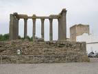
 Évora é uma cidade portuguesa, capital do Distrito de Évora, e situada na região Alentejo e sub-região do Alentejo Central. Évora é uma cidade portuguesa, capital do Distrito de Évora, e situada na região Alentejo e sub-região do Alentejo Central.
Com pouco mais de 50 mil habitantes, Évora fascina pela monumentalidade e pelo equilibrio da paisagem urbana. O seu centro histórico, classificado pela UNESCO desde 1987 como "Património da Humanidade", é considerado um modelo de preservação dos vestígios do passado, apesar de nele habitarem mais de 18 mil pessoas. Até há cerca de 50 anos, constituía o essencial da cidade e eram poucos os edifícios ou arruamentos existentes nos espaços exteriores. Vastos campos de trigo, canaviais e ferragiais circundavam então o velho burgo.
Hoje, a cidade ultrapassou as muralhas e espraia-se por cerca de 40 bairros circundantes. Merece particular destaque o da Malagueira, concebido por Siza Vieira e premiado internacionalmente. Nao esquecer, porém, outras intervenções recentes: o Centro Comercial Eborim (Fernando Bagulho), as lojas e habitações de Santa Catarina (Silva Graça) e a inteligente renovação do Teatro Garcia de Resende (Miguel Lima).
A quem chega a Évora recomenda-se que, antes de visitar as muralhas, admire o Aqueduto da Água de Prata, cuja construção remonta a 1574 e trazia água da Graça do Divor para a Praça do Giraldo, agora praticamente desafrontado em virtude da modificação e da modernização dos acessos à cidade.
Perto do local onde a sua monumental arcaria emerge, fica o Convento da Cartuxa, um notável exemplar da arquitectura seiscentista, no qual actualmente cinco escassos monges persistem em manter aceso o espírito da ordem, vivendo em ruptura com o mundo. A dois passos situa-se o Convento de S. Bento de Castris, a mais antiga fundação monástica do Sul do país. Começou por ser ermida em 1169 e transformou-se em igreja conventual em 1328. Ainda fora das muralhas, no vasto Rossio, ergue-se a Ermida de S. Brás, construída cerca de 1490 para substituir uma albergaria que serviu de acolhimento aos afectados pelo surto de peste. |
 Évora is a Portuguese city, capital of District's Évora, and located in the Alentejo region of Alentejo subregion and Central. Évora is a Portuguese city, capital of District's Évora, and located in the Alentejo region of Alentejo subregion and Central.
With little more than 50 thousand inhabitants, Évora fascinates for the history and the balance of the urban landscape. Its historical center, classified for UNESCO since 1986 as “Heritage of the Humanity”, is considered a model of preservation of the vestiges of the past, although in it to inhabit more than 18 thousand people. Until about 50 years, was the essential of the city and were a few buildings and squares in the exterior spaces. Vast fields of wheat, surrounded the old town.
Today, the city exceeded the walls and is extended for about 40 surrounding quarters. It deserves particular detached Malagueira, designed by Siza Vieira and internacionally awarded. No forget, however, other interventions: the Commercial Center Eborim (Fernando Bagulho), the stores and habitations of Santa Catarina (Silva Graça) and the intelligent renewal of the Theater Garcia de Resende (Miguel Lima).
Who visit Évora is recommended that before visit the walls, admire the Aqueduto da Água de Prata, wich construction dates to 1574 and brought the water of Graça do Divor for the Praça do Giraldo, now changed and modernized to access the city.
Near the local where his monumental arcaria emerge, is the Convento da Cartuxa, a remarkable copy of the old architecture, which currently five monks persist in keeping up the spirit of the order, living at odds with the world. Nearby is the Convento de São Bento de Castris, the oldest monastic foundation of the South. It began with chapel in 1169 and transformed itself into church convent in 1328. Even outside the walls in the vast Rossio, stands the Ermida de S. Brás, built around 1490 to replace a hotel that served as host to those affected by the plague. |
Gastronomia local / Local gastronomy:
Migas com carne de porco, sopa de tomate, sopa de cação , poejada de bacalhau, gaspacho, açorda, ensopada de borrego e encharcada.
|
|
 Montemor-o-Novo é uma cidade portuguesa, no Distrito de Évora, região Alentejo e sub-região do Alentejo Central, com cerca de 12.000 habitantes. É uma cidade com forte crescimento habitacional e é sede de um dos maiores municípios de Portugal, com 1.232,10 km⊃2; de área e 18.578 habitantes(2001), subdividido em 10 freguesias. Montemor-o-Novo é uma cidade portuguesa, no Distrito de Évora, região Alentejo e sub-região do Alentejo Central, com cerca de 12.000 habitantes. É uma cidade com forte crescimento habitacional e é sede de um dos maiores municípios de Portugal, com 1.232,10 km⊃2; de área e 18.578 habitantes(2001), subdividido em 10 freguesias.
A cidade de Montemor-o-Novo - sede de concelho, povoação de origem muito antiga, situava-se inicialmente na parte interior da muralha do Castelo, expandindo-se posteriormente pela encosta virada a norte, onde actualmente se localiza.
Na economia a produção de carne é o seu principal factor sendo o concelho do país que mais carne produz. Nos últimos anos foram feitos grandes investimentos desportivos, novas piscinas descobertas (com cerca de 50 mil visitantes ano) e cobertas, novo gimno-desportivo, 4 courts de ténis, bancada no Estádio 1.º de Maio e construção de um novo Estádio Municipal (sintético).
|
 Montemor-o-Novo is a Portuguese city, in Évora, in Alentejo region, with about 12,000 inhabitants. It is a city with strong housing growth and is one of the largest municipalities in Portugal, with 1232.10 square kilometers of area and 18,578 inhabitants (2001), divided in 10 parishes. Montemor-o-Novo is a Portuguese city, in Évora, in Alentejo region, with about 12,000 inhabitants. It is a city with strong housing growth and is one of the largest municipalities in Portugal, with 1232.10 square kilometers of area and 18,578 inhabitants (2001), divided in 10 parishes.
The city of Montemor-o-Novo, seat of the Municipality, old village, was initially placed inside the wall of the Castle, spreading afterwards to the northern slope where it is presently set.
In economics, meat production is the main factor being the county in the country which produces more meat. In recent years have made large investments in sports, new pools discovered (with about 50 thousand visitors year) and covered, new gimno-sports, 4 tennis courts, stand in the stadium 1º de Maio and construction of a new Municipal Stadium ( synthetic).
|
Gastronomia local / Local gastronomy:
Empadas, enchidos, mel, cernelhas, queijadas, doçaria conventual, pão, vinho e os tradicionais licores de poejo e granito.
|
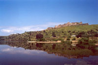
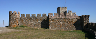
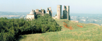
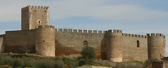
 Mourão é concelho raiano da margem esquerda do Rio Guadiana, transformado no maior lago artificial da Europa. Aqui, a planura das águas é mais larga, tornando a Vila de Mourão ribeirinha, sob o olhar altaneiro e vigilante do Castelo de Mourão. Mourão é concelho raiano da margem esquerda do Rio Guadiana, transformado no maior lago artificial da Europa. Aqui, a planura das águas é mais larga, tornando a Vila de Mourão ribeirinha, sob o olhar altaneiro e vigilante do Castelo de Mourão.
Do alto do Castelo de Mourão desfruta-se uma grande panorâmica sobre a paisagem envolvente. Assim, para além da vista a sul sobre o casario de Mourão, agarrado às faldas do Castelo, para norte observa-se o mar de água do rio Guadiana que o Alqueva aprisionou e o Castelo e Vila de Monsaraz localizados no alto de uma elevação de declive muito acentuado e com quem o Castelo de Mourão estabelece cumplicidades há muito tempo. Abraçando a água, estão os campos de cultivo que do lado norte apresentam formas irregulares de acordo com o relevo, delimitados por muros de pedra seca de xisto com oliveiras “entaladas”, que foram para aí “empurradas” de forma a deixar livre o terreno para o cultivo dos cereais. A sul, envolvendo a vila, os campos de cultura ocupados essencialmente por olivais e vinhas, são de forma regular e pequena área determinados quer pela topografia, já que o relevo se apresenta aplanado, quer pelos solos que são de muito boa qualidade o que terá levado a sucessivas partilhas ao longo das gerações. |
 Mourão is the frontier Municipality of the left shore of the River Guadiana, transformed into the biggest artificial lake in Europe. Here, the water plain is wider, making the town of Mourão a riparian one, under the towering and vigilant look of the Castle. Mourão is the frontier Municipality of the left shore of the River Guadiana, transformed into the biggest artificial lake in Europe. Here, the water plain is wider, making the town of Mourão a riparian one, under the towering and vigilant look of the Castle.
From the top of the Castle of Mourão you can enjoy a large panoramic over the surrounding landscape. Thus, besides the southern view over the rows of houses of Mourão, addorsed to the briskets of the Castle, we observe, northern the water sea of the River Guadiana the Alqueva has captured, as well as the Castle and town of Monsaraz placed in the top of a hill with a most accentuated acclivity with which the Castle of Mourão has establish an ancient complicity. Embracing the water are the culture years presenting irregular shapes in the northern side, according to the relief, limited by schist dry stone walls with wedged olive-trees, which were pushed there to free the ground for the culture of cereals. Southern, surrounding the town, the culture yards mostly occupied by olive tree yards and vineyards, they have a regular form and small areas determined either by the topography once the relief is planed, or by the soil quality which may have led to successive partitions through generations. |
Gastronomia local / Local gastronomy:
Açorda de cação, borrego assado no forno, sopa da panela, calducho, bolo rançoso e bolo podre.
|
 Território marcado por uma paisagem dominada pela serra, Portel assume-se hoje como a “Capital do Montado” e a porta de acesso a Alqueva. Território marcado por uma paisagem dominada pela serra, Portel assume-se hoje como a “Capital do Montado” e a porta de acesso a Alqueva.
Obra grandiosa localizada no coração do Alentejo, a Barragem de Alqueva, insere-se na bacia hidrográfica do Rio Guadiana e desde 2002 está a formar o maior lago artificial da Europa.
A albufeira ocupa uma área de cerca de 250km2, sendo o seu perímetro de 1160 km, estendendo-se ao longo dos municípios de Portel, Mourão, Moura, Reguengos de Monsaraz e Alandroal. |
 Territory marked by a landscape dominated by mountains, Portel it is assumed today as the "Capital do Montado" and gateway to Alqueva. Great work situated in the heart of the Alentejo, the dam of Alqueva, fits into the basin of Rio Guadiana and since 2002 is to form the largest artificial lake in Europe. Territory marked by a landscape dominated by mountains, Portel it is assumed today as the "Capital do Montado" and gateway to Alqueva. Great work situated in the heart of the Alentejo, the dam of Alqueva, fits into the basin of Rio Guadiana and since 2002 is to form the largest artificial lake in Europe.
The lake occupies an area of about 250km2, and its perimeter of 1160 km, extending up over the municipalities of Portel, Mourao, Moura, Reguengos de Monsaraz and Alandroal. |
Gastronomia local / Local gastronomy:
Açorda de peixe do rio, cozido de grão de bico, rechina, bolos folhados e pastéis de grão.
|
 O concelho de Redondo situa-se no Alentejo Central e estende-se por uma área de 371 km2, correspondendo a 5,1% da área total do Alentejo Central. O concelho de Redondo situa-se no Alentejo Central e estende-se por uma área de 371 km2, correspondendo a 5,1% da área total do Alentejo Central.
Viva as festividades, tradições e cultura do concelho de Redondo. Em Agosto, de dois em dois anos, percorra inúmeras ruas adornadas com maravilhosas formas coloridas de papel, saídas do trinar das tesouras e da imaginação da população; aperfeiçoe os seus dotes manuais e veja como uma massa disforme de barro ganha formas extraordinárias ao ritmo das mãos experimentadas de um oleiro. Redondo é terra de tradições e artesãos, não perca esta oportunidade e venha experimentar aquilo que de melhor este concelho tem para lhe oferecer. |
 The county of Redondo is located in the Alentejo Central and extends over an area of 371 km2, representing 5.1% of the total area of Alentejo Central. The county of Redondo is located in the Alentejo Central and extends over an area of 371 km2, representing 5.1% of the total area of Alentejo Central.
Enjoy the festivities, traditions and culture of the county from Redondo. In August, every two years, scroll through numerous streets decorated with wonderful shapes of colored paper, leaving the trill of scissors and imagination of the population, improve their manuals skills and see how a mass of mud gets extraordinary shapes in the hands of a potter. Redondo is a land of traditions and crafts, do not miss this opportunity to visit and the better what this county has to offer. |
Gastronomia local / Local gastronomy:
Sopa de espargos bravos, lebre frita, migas à Alentejana, ensopado de borrego e arroz-doce.
|
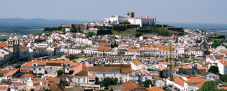
 O Concelho de Reguengos de Monsaraz pertence ao Distrito de Évora e localiza-se na Região Alentejo, no Sul de Portugal. O Concelho de Reguengos de Monsaraz pertence ao Distrito de Évora e localiza-se na Região Alentejo, no Sul de Portugal.
É confinado a Norte pelos Concelhos de Redondo e Alandroal, a Este pelo concelho de Mourão, a Sul pelos concelhos de Moura e Portel e a Oeste pelos concelhos de Évora e parte do de Portel.
O seu limite a Sudeste é banhado pela albufeira de Alqueva, numa extensão de 200 km.
O Concelho abrange uma área de cerca de 474 Km⊃2; e é composto por 5 freguesias e correspondentes aglomerados.
O Concelho está enquadrado na magnífica planície alentejana e no azul da Albufeira do Alqueva. O Concelho faz parte do Distrito de Évora. É uma zona principalmente agrícola (cereais, olivais e vinha), caracterizada por Verões quentes e longos e Invernos curtos e chuvosos.
Podem-se encontrar aqui numerosos monumentos arqueológicos, principalmente monumentos megalíticos. Para além dos monumentos megalíticos é também obrigatória uma visita à Vila de Monsaraz e deixar-se levar através do tempo. |
 The City of Reguengos de Monsaraz belongs to Évora's district and is located in the Alentejo region, in southern Portugal. It is confined to the northern municipalities of Redondo and Alandroal, the east by the county for Mourao, in the southern counties of Moura and Portel and west by Évora and Portel. The City of Reguengos de Monsaraz belongs to Évora's district and is located in the Alentejo region, in southern Portugal. It is confined to the northern municipalities of Redondo and Alandroal, the east by the county for Mourao, in the southern counties of Moura and Portel and west by Évora and Portel.
It limited is bathed in the southeast of Alqueva dam, a length of 200 km.
The county covers an area about 474 square kilometers and is comprised of 5 parishes and corresponding clusters. Is framed in the great plains of Alentejo and the blue of dam Alqueva. The county is part of the District of Évora. It is a mainly agricultural area (cereals, olive groves and vineyards), characterized by warm summers and long and short, rainy winters.
You can find numerous archaeological monuments, especially megalithic monuments. In addition to the megalithic monuments is also an obligatory visit to the Vila de Monsaraz and get going through time. |
Gastronomia local / Local gastronomy:
Gaspacho, açorda, peixe do rio, migas de espargos, cação à Alentejana e perdiz brava estufada.
|
 Sousel é uma vila portuguesa situada no Distrito de Portalegre, região Alentejo e sub-região do Alentejo Central, com cerca de 2 100 habitantes. Sousel é uma vila portuguesa situada no Distrito de Portalegre, região Alentejo e sub-região do Alentejo Central, com cerca de 2 100 habitantes.
É sede de um município com 278,94 km⊃2; de área e 5 780 habitantes (2001), subdividido em 4 freguesias. O município é limitado a norte pelos municípios de Avis e Fronteira, a leste e sul por Estremoz, a sudoeste por Arraiolos e a oeste por Mora.
O Concelho de Sousel situa-se na confluência dos Distritos de Portalegre e Évora, numa região marcada pela multiplicidade paisagística. O clima mediterrânico é marcado por uma estação seca bem acentuada (Verão), e pelas estações mais amenas da Primavera e do Outono. |
 Sousel is a Portuguese village located in the District of Portalegre, and Alentejo region of Alentejo Central subregion, with about 2 100 inhabitants. Sousel is a Portuguese village located in the District of Portalegre, and Alentejo region of Alentejo Central subregion, with about 2 100 inhabitants.
It is the seat of a municipality with 278.94 square kilometers of area and 5 780 inhabitants (2001), divided into 4 parishes. The council is limited to northern cities to Avis and Fronteira, east and south by Estremoz, the southwest by Arraiolos and west by Mora.
The Municipality of Sousel is situated at the confluence of the districts of Portalegre and Évora, in a region marked by many sights. The Mediterranean climate is marked by a well marked dry season (Summer), and the milder seasons of Spring and Autumn. |
Gastronomia local / Local gastronomy:
Açorda com coentros, cachola com cominhos, gaspacho com orégãos, cozido de grão com hortelã e salada de pepino com poejo.
|
 A Cidade e o Concelho de Vendas Novas inserem-se na Região do Alentejo, Distrito de Évora. A Cidade e o Concelho de Vendas Novas inserem-se na Região do Alentejo, Distrito de Évora.
O concelho de Vendas Novas é constituído por sete aglomerados urbanos – Vendas Novas, Landeira, Bombel, Afeiteira, Piçarras, Nicolaus e Marconi – ocupando uma área total de 222,5 Km2.
O seu clima apresenta afinidades mediterrâneas e continentais, caracterizando-se fundamentalmente pelo tempo seco e quente. As temperaturas médias no Verão variam entre os 21ºC e os 25ºC, podendo no entanto apresentar temperaturas superiores a 35ºC. |
 The City and County of Vendas Novas belongs to the region of Alentejo, Évora. The City and County of Vendas Novas belongs to the region of Alentejo, Évora.
The county of Vendas Novas consists of seven urban areas – Vendas Novas, Landeira, Bombel, Afeiteira, Piçarras, Nicolaus and Marconi - occupying a total area of 222.5 km2.
Its climate presents Mediterranean and continental affinities, is fundamentally characterized by hot and dry weather. The average temperature in Summer varies between 21ºC and 25° C and can however submitting temperatures exceeding 35°C. |
Gastronomia local / Local gastronomy:
Bifanas e tomatada.
|
 Viana do Alentejo é uma vila portuguesa, no Distrito de Évora, região Alentejo e sub-região do Alentejo Central, com cerca de 2 800 habitantes. Viana do Alentejo é uma vila portuguesa, no Distrito de Évora, região Alentejo e sub-região do Alentejo Central, com cerca de 2 800 habitantes.
É sede de um município com 393,92 km⊃2; de área e 5 615 habitantes (2001), subdividido em 3 freguesias.
O Concelho de Viana do Alentejo é conhecido pela sua riqueza patrimonial. Exemplo disso, são o Santuário Mariano de N.ª Sr.ª D'Aires, o Castelo de Viana e a Igreja Matriz do Salvador. |
 Viana do Alentejo is a Portuguese village in the district of Évora, Alentejo region and subregion from Alentejo Central, with about 2 800 inhabitants. Viana do Alentejo is a Portuguese village in the district of Évora, Alentejo region and subregion from Alentejo Central, with about 2 800 inhabitants.
It is the seat of a municipality with 393.92 square kilometers of area and 5 615 inhabitants (2001), divided into 3 parishes.
The Municipality of Viana do Alentejo is known for its rich heritage. Examples are the Santuário Mariano de Nª Sr.ª D'Aires, the castle of Viana and the Church Matriz do Salvador. |
Gastronomia local / Local gastronomy:
Migas à Alentejana, sopa de poejos com ovos ou poejada e sopa de espargos bravos.
|
 Com 8.871 habitantes, distribuídos por 194.62 Km2 de área, Vila Viçosa é um dos mais importantes concelhos do distrito de Évora. Com 8.871 habitantes, distribuídos por 194.62 Km2 de área, Vila Viçosa é um dos mais importantes concelhos do distrito de Évora.
No contexto do Alentejo, o concelho de Vila Viçosa é particularmente privilegiado em termos de património natural, do qual se destacam o património geológico e a vegetação dos vales viçosos. Motivos de interesse paisagístico, geológico e arqueológico. |
 With 8871 inhabitants, distributed by area of 194.62 km2, Vila Viçosa is one of the most important counties in the district of Évora. As part of Alentejo, the county of Vila Viçosa is particularly privileged in terms of natural heritage, we can highlight the geological heritage of the valleys and a great vegetation. Subjects of interest geological, archaeological and landscape. With 8871 inhabitants, distributed by area of 194.62 km2, Vila Viçosa is one of the most important counties in the district of Évora. As part of Alentejo, the county of Vila Viçosa is particularly privileged in terms of natural heritage, we can highlight the geological heritage of the valleys and a great vegetation. Subjects of interest geological, archaeological and landscape. |
Gastronomia local / Local gastronomy:
Açorda Alentejana, carne de porco à Alentejana, entrecosto frito com migas de tomate e tibornas.
|