Bastions in Komárno
Komárnanské bašty
Komáromi bástyarendszer
English
description:
The fortress in Komárno was the
largest fortification system of the Monarchy. Because of its
historical and architectonic value, the fortress is declared as a
national cultural monument. It was built at the confluence of the
Váh and Danube Rivers.
- The Old fortress
(A)
Built between 1546-57 with the participation of Italian military
engineers.
- The New fortress
(B)
Built between 1663-73, it was connected with the Old fortress by a
bridge leading over a wide and deep moat.
- The Palatine
line: I.-VI. bastions
(C1-C6)
Built between 1839-47 as a defensive chain of new prussian
type.
- The Váh
line: VI.-VII. bastions
(C6-C7) and VIII.-XI. ramparts
(D1-D4)
Chain of fortifications built in the seventies of the 19th century
at the River Váh, spreading as far as the confluence of the Váh and
Danube Rivers.
More
information and photos about fortress system in Komárno you can
find on websites:
www.infokomarno.sk,
www.komarno.sk, www.komarno-csarda.sk/bastyarendszer.htm.
Slovak
description:
Komárnanská pevnost bola najväcším
pevnostným systémom rakúsko-uhorskej monarchie. Pre svoju
historickú a architektonickú hodnotu je pevnost vyhlásená za
národnú kultúrnu pamiatku. Pevnost zacali budovat na mieste, kde sa
Váh vlieva do Dunaja.
- Stará pevnost
(A)
Postavená v rokoch 1546-57. Na jej výstavbe sa podielali taliansky
vojenský inžinieri.
- Nová pevnost
(B)
Postavená v rokoch 1663-73, so Starou pevnostou bola spojená mostom
ponad vodnú priekopu.
- Palatínska
línia: I.-VI. bašty
(C1-C6)
Postavená v rokoch 1839-47 ako obranná retaz novopruského
typu.
- Vážska
línia: VI.-VII. bašty
(C6-C7) a VIII.-XI. fortifikacné objekty
(D1-D4)
Pozostáva z fortifikacných objektov postavených v sedemdesiatich
rokoch 19. storocia pri rieke Váh až k sútoku s
Dunajom.
Dalšie
informácie a fotografie o komárnanskom
pevnostnom systéme nájdete na
webstránkach:
www.infokomarno.sk,
www.komarno.sk
, www.komarno-csarda.sk/bastyarendszer.htm.
Hungarian
description:
A Komáromi erod az
Osztrák-Magyar Monarchia legnagyobb erodrendszere volt. Történelmi
és építészeti értéke miatt az erodöt nemzeti kulturális muemléknek
nyilvánították. Az erodöt a Vág és a Duna összefolyásánál kezdték
építeni.
- Az Öregvár
(A)
1546-1557 között épült. Építésében olasz katonai építészek is
közremuködtek.
- Az Újvár
(B)
1663-1673 között épült. Az Öregvárral egy széles vizesárok fölötti
híd kötötte össze.
- A
Nádor-vonal: I.-VI. bástyák
(C1-C6)
Az erodrendszer 1839 és 1947 között épült új porosz típusú
védovonal mintájára.
- A
Vág-vonal: VI.-VII. bástyák
(C6-C7) és
VIII.-XI. várdák (D1-D4)
A 19. század hetvenes éveiben épült a Vág folyó mentén, egészen a
Duna és a Vág összefolyásáig.
A
komáromi erodrendszerrol további információkat és fényképeket
találtok az alábbi weboldalakon:
www.infokomarno.sk
,
www.komarno.sk, www.komarno-csarda.sk/bastyarendszer.htm.
This
multicache will shows you the I.-VII. bastions (C1-C7 on the
map above). First you have to answer tree questions in the I., IV.
and V. bastion, find three micro containers in the II., III. and
VI. bastions and then the regular sized geocache near the VII.
bastion.
DO NOT SEARCH CACHES IN THE DARK!
Be careful where you step, because more times you will
be on the top of the 5-6 m high walls of bastions (or on the edge
of the deep and precipitous moat).
Táto
multicache vám ukáže I.-VII. bašty (C1-C7 na mape hore). Najprv
budete musiet odpovedat na tri otázky v I., IV. a
V. bašte, nájst tri mikroschránky v
II., III. a VI. bašte, a potom geoschránku tradicnej velkosti pri
VII. bašte.
SKRÝŠE NEHLADAJTE V TME! Vždy sa
pozerajte pod svoje nohy, kedže aj viackrát budete na 5-6 m vysokej
stene bášt (alebo na okraji hlbokej a strmej
priekopy).
Ez a
multicache az I.-VII. bástyába kalauzol el benneteket (C1-C7 a
fenti térképen). Elobb válaszolnotok kell három kérdésre az I., IV.
és V. bástyában, megkeresni három mikro ládát a II., III. és VI.
bástyákban, majd ezek alapján megkeresni a hagyományos méretu
geoládát a VII. bástyánál.
A LÁDÁKAT NE KERESSÉTEK SÖTÉTBEN! Mindig nézzetek a
lábatok elé, ugyanis többször is lesztek az 5-6 m magas bástyafal
tetején (vagy a mély és meredek árok szélén).

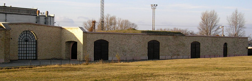
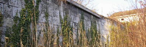
In the first half
of the 20th century some parts of I. bastion were demolished; only
Bratislava Gate and some parts of the retranchments survived. From
the waypoint N 47°
45.690' E 018°
06.591' (BAST1)
you can see the picture above. A
= How many window is
missing on the picture above?
V prvej polovici
20. storocia došlo k rozbúraniu niektorých castí I. bašty;
zachovala sa z nej len Bratislavská brána a fragment
retranchementu. Z bodu N 47°
45.690' E 018°
06.591' (BAST1)
môžete vidiet obrázok hore. A = Kolko okien
chýba na obrázku hore?
A 20. század elso
felében lebontásra került az I. bástya néhány része; csak a
Pozsonyi-kapu és a retranchement egy része maradt fenn belole. Az
N 47° 45.690' E
018° 06.591' (BAST1) pontról
látható a fenti kép. A
= Mennyi ablak hiányzik a fenti
képrol?


Through the gate N
47° 45.951' E
018° 06.677'
(BAST2G) you can go into the II. bastion (it worth to see it).
But the micro container with the next part of final coordinates is
NOT accessible from this side of the bastion. You can find it on
the coordinates N 47°
45.915' E 018°
06.603' (BAST2) from other side of
the bastion. You will have to climb down a little.
Cez bránu N
47° 45.951' E
018° 06.677'
(BAST2G) sa môžete dostat do vnútra II.
bašty (oplatí sa tam pozriet), ale
mikroschránka s dalšou castou finálnych súradníc z tejto strany
bašty NIE je dosiahnutelný. Nájdete ju na súradniciach
N47° 45.915' E
018° 06.603' (BAST2), kam sa
môžete dostat z druhej strany bašty. Budete musiet trochu liezt
dole.
Az N
47° 45.951' E
018° 06.677'
(BAST2G) koordinátákon található kapun
keresztül bejuthattok a II. bástya belsejébe (megéri megnézni), de
a mikro láda az utolsó pont koordinátáinak további részével a
bástya ezen oldaláról NEM érheto el. A mikro láda az
N47° 45.915' E
018° 06.603' (BAST2) koordinátákon
található, amely a bástya másik oldaláról közelítheto meg. Egy
kicsit kell majd lefele mászni.

The III. bastion
is used as storage place by different companies, thus the large
part of this bastion is not accessible. To find this stage may be
the most difficult. The micro container with the next part of final
coordinates is in the bush area, down in the deep, on the waypoint
N 47° 46.160' E
018° 06.827'
(BAST3). There is only one field path leading down to the
container, which continuous with the very bushed foot path in the
jungle!
III.
bašta sa používa ako sklad pre rôzne firmy, preto
velká cast bašty nie je dostupná. Najdenie tejto schranky
bude asi najtazsia zo vsetkych. Mikroschránka s dalšou castou
finálnych súradníc je v džungli, dole v
priekope, na bode N 47°
46.160' E 018°
06.827' (BAST3). Ku
schránke vedie dole do priekopy iba jedna
polná cesta, ktorú
potom nahradí velmi zarastený chodník v
džungli!
A III. bástya
raktárhelyiségként szolgál különbözo cégeknek, ezért a bástya nagy
része nem közelítheto meg. Talán ennek a ládának a
megtalálása lesz a legnehezebb. A mikro láda az utolsó pont
koordinátáinak további részével a dzsungelben van, lent az árokban,
az N 47°
46.160' E 018°
06.827' (BAST3) koordinátákon. A
ládához csak egyetlen mezei út vezet le, amely folytatódik egy
nagyon benott gyalogúttal a dzsungelben!
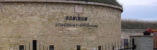
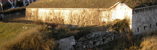
The IV. bastion is
also used as storage place by different companies, thus it
isn't accessible. From
the waypoint N 47°
46.405' E 018°
07.108'
(BAST4) you can see the picture
above, but in this picture is missing the third line of the text
written on the wall. B = the number of
characters in the third line.
IV.
bašta sa tiež používa ako sklad pre rôzne
firmy a preto nie je
dostupná. Z bodu N
47° 46.405' E 018°
07.108' (BAST4) môžete vidiet obrázok
hore, ale na tomto obrázku chýba tretí riadok textu zo steny. B
= pocet písmen v tretom riadku.
A IV. bástya
szintén raktárhelyiségként szolgál különbözo cégeknek, ezért a
bástya nem közelítheto meg. Az N47°
46.405' E 018°
07.108' (BAST4) ponton a fenti kép
látható, de ezen a képen hiányzik a szöveg harmadik sora a falról.
B = a betuk száma a harmadik
sorban.


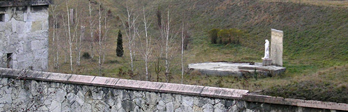
In the V. bastion
is T-Gallery, which entry is on the coordinates N
47° 46.600' E
018°
07.372' (BAST5G). Opening hours:
Mon.-Fri. 9.00-17.00, Sat. 9.00-12.00 (for information you can call
the phone number +421905593998). It worth to see the gallery and
the bastion from inside. For finding the next part of final
coordinates go to the waypoint N 47°
46.641' E 018°
07.401' (BAST5) (outside the
gallery), to the top of the wall of bastions (above the gate). You
can see from this point a sculpture inside some columns (in the
picture above the columns are missing). C = the
number of columns around the sculpture.
Vo vnútri
V. bašty je T-Galéria,
ktorej vstupná brána je na súradniciach N
47° 46.600' E
018°
07.372' (BAST5G).
Otváracie hodiny: Pon.-Pia. 9.00-17.00, Sob. 9.00-12.00 (informovat
sa môžete na telefónnom císle +421905593998). Oplatí sa íst
dovnútra pozriet si galériu a aj baštu z vnútra. K nájdeniu dalšej
casti finálnych súradníc nemusíte íst dovnútra do galérie. Chodte
na bod N 47°
46.641' E 018°
07.401' (BAST5), ktorá sa nachádza na
vrchole steny bášt (nad bránou). Z tochto bodu môžete vidiet jednu
sochu obklopenú stlpcami (na obrázku hore stlpce chýbajú). C =
pocet stlpov okolo sochy.
Az V. bástyában
T-Galéria található, melynek kapuja az N
47° 46.600' E
018°
07.372' (BAST5G) koordinátákon van.
Nyitvatartása: Hét.-Pén. 9.00-17.00, Szo. 9.00-12.00
(érdeklodni a +421905593998 telefonszámon
lehet). Megéri bemenni, megnézni a
galériát és a bástyát is belülrol. Az utolsó pont további
koordinátarészének megtalálásához azonban nem kell bemenni a
galériába. Ehhez menjetek az N 47°
46.641' E 018°
07.401' (BAST5) pontra, amely a
bástyafal tetején található (a kapu felett). Innen jól látható egy
szobor, amely körül oszlopok vannak (a fenti képen az oszlopok
hiányoznak). C = a szobor körül található
oszlopok száma.

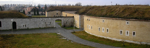
The VI. bastion is
renovated and full accessible, enjoy it! In the building of the
bastion is Roman
Lapidarium and restaurant (Bástya csárda) as well. On
the coordinates N
47°
46.644' E 018°
07.810' (BAST6) is a micro container
with the next part of final coordinates. Be careful, for finding
the container you do not need to go to the edge of the wall of the
bastion!
VI.
bašta je renovovaná a v plnej miere dostupná,
vychutnávajte si túto možnost a dobre si pozrite baštu zo všetkých
strán! V budove bašty nájdete Rýmske
Lapidárium a aj reštauráciu (Bástya csárda). Na
súradniciach N
47°
46.644' E 018°
07.810' (BAST6) je mikroschránka s
dalšou castou finálnych súradníc. Budte opatrný, k
najdeniu mikroschránky nemusíte íst na okraj steny
bášt!
A VI. bástya
felújított és teljes mértékben hozzáférheto, élvezzétek ki ezt a
lehetoséget és jól nézzétek meg a bástyát minden oldalról! A bástya
épületében Római
Lapidáriumot és egy éttermet (Bástya csárda) is
találtok. Az N
47°
46.644' E 018°
07.810' (BAST6) koordinátákon egy
mikro láda található az utolsó pont koordinátáinak további
részével. Legyetek óvatosak, a láda megtalálásához
nem kell a bástyafal széléhez mennetek!

The geocache
(regular 1 litre container) is on the final coordinates near
the VII. bastion (to get the final coordinates put together the
parts of coordinates which you have found in the I.-VI.
bastions).
Geoschránka
velkosti 1 liter je na finálnych súradniciach pri VII. bašte (k
získaniu finálnych súradníc zložte do kopy jednotlivé casti
súradníc najdených v I.-VI.
baštách).
Az 1 literes
geoláda a VII. bástyánál van elrejtve (a geoláda koordinátáit
megkapjátok, ha összerakjárok az I.-VI.
bástyákban megtalált koordináta darabokat).