View Larger Map

NPS Photo
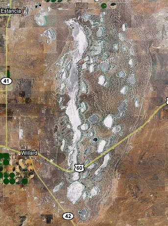
Located generally east of Willard and Estancia in central Torrance county, these lakebeds, or more accurately the remains of a once larger lake, played a unique role in the history of this area.
Although the more recent history of the area centers around ranching (Estancia means ranch), the Pueblo people and the Spanish colonizers recovered salt from these lakebeds, the largest of which is known as Laguna del Perro.
Long ago, a Pueblo man showed Salt Woman hospitality, even though her body was rough and scaly. In return, she made her home nearby in a lake, so that people might come there with offerings and take away the salt that is her body.
Pueblo legend[1]
As noted at the National Park Service website, the “once, thriving American Indian trade communities of Tiwa and Tompiro speaking Puebloans inhabited this remote area of central New Mexico. Early in the 17th-century Spanish Franciscans visited the area and found it ripe for their missionary efforts. However by 1677 the entire Salinas District, was depopulated of both Indian and Spaniard.”[2]
To learn why, visit the Salinas Pueblo Missions National Monument visitors center in Mountainair and/or the abandoned pueblos at Quarai, Abó, and Gran Quivira. "Salinas Pueblo Missions was set aside because of the importance of the cultural resources, however, there is a major connecting link to the natural resources. The link is the importance of man's adjustment to a marginal land and the man-land relationship during the past 1,000+ years of occupation.
“Salinas Pueblo Missions is positioned within the Estancia Basin, east of the Manzano Mountains. In Pleistocene time [before 10,000 years ago] the Estancia Basin held a lake. Surrounding the margins of the valley beaches, bars, and spits are distinguishable. Eventually the lake dried up and the American Indians associated with the pueblos of Salinas cultivated staple foods such as corn, beans, and squash, on the fine loamy lake deposits.”[3]

Geologist Virginia T. McLemore of New Mexico Tech gave a more detailed explanation in New Mexico Geology:
The Estancia Basin “initially formed as a depositional basin during the Early Pennsylvanian with the deposition of the Sandia Formation and Madera Group [more than 300 million years ago]. The present structural basin formed when the Sandia, Manzano, Manzanita, and Los Pinos Mountains were uplifted during formation of the Rio Grande rift about 20–15 [million years] ago. The Sandia, Manzano, Manzanita, and Los Pinos Mountains form the western boundary, the Pedernal Hills form the eastern boundary, Chupadera Mesa forms the southern boundary, and Lobo Hill separates the Estancia Basin from the Española Basin to the north).
“During the last ice age between 24,000 and 12,000 [years ago], a large pluvial lake filled the basin. The maximum extent of the lake was approximately 40 mi long, 23 mi wide, and it would have covered the towns of Estancia and Willard with nearly 100 ft of water. Shore features, cliffs, terraces, beach ridges, and other lake features, preserved in the Estancia Basin ... record a series of changing water levels in the lake from 24,000 to 12,000 [years ago] caused by rapid shifts in climate. Lake Estancia gradually dried up after about 12,000 [years ago], and the floor became exposed. A return to wetter conditions resulted in the filling of the basin again by a younger lake (called Lake Willard by some geologists) at about 10,000 [years ago]. These lakes did not have any outlets to the Rio Grande or anywhere else, and the water became saline over time, in part as a result of evaporation and also as a result of contributions from underlying Yeso evaporites.
“Today, a complex of playa lakes and surrounding gypsum and clay dunes remain following excavation or deflation of the ancient lake bottom since about 8,000 [years ago] by southwesterly wind. An overall rise in the water table and return to a slightly wetter climate have reversed the trend from deflation to sediment filling of the lakes. As saline water in some of the playas evaporated, a residue of halite (salt) and minor sodium sulfates and magnesium sulfates precipitated. The deposits of halite became valuable commodities to the Pueblo Indians that settled at Abò, Quarai, and Gran Quivira and later to the Spanish and Anglo settlers. Today, the playa lakes in Estancia Basin range in size from a few acres to more than 12 mi long.”[4]
To log this EarthCache:
1. Visit an area near one of the lakebeds just off US Route 60, preferably at the posted coordinates where there is adequate safe parking. In your log, post a photo of yourself and/or your GPSr with a lake or lakes in the background. As of 1 January 2011, photographs are optional, but we'd still like to see what you saw!
The placing of this EarthCache does not grant or imply permission to trespass on private property and you will not need to cross fences or hike to a lakebed to log this EarthCache.
2. At the roadside parking area on US 60 (posted coordinates), take an elevation reading with your GPSr or read the elevation from the New Mexico historic marker. Also note the depth of the lake during the late Pleistocene as indicated on the sign. Take another elevation reading at the low point along the highway between here and Willard, near waypoint listed below [Low Point]. Take a third elevation reading at the town of Willard. Send your readings and your determination of the depth of the water at the historic marker/parking area and at Willard. Do you agree that Willard (had it been there 10,000 years ago) would have been 100 feet underwater? Please do not post your answers in your log.
3. Bonus Learning: Visit the Salinas Pueblo Missions National Monument visitors' center on Route 60 in Mountainair (corner of W.Broadway and S. Ripley) at the coordinates listed below[Mountainair Visitor Center]. Learn the reason Spanish officials forced Pueblo people to collect salt here.
References:
- Visitor Center, Salinas Pueblo Missions National Monument, Mountainair, NM, https://www.nps.gov/sapu/planyourvisit/directions.htm
- Salinas Pueblo Missions National Monument, https://www.nps.gov/sapu/
- Salinas Pueblo Missions National Monument - Nature & Science, https://nps.gov/sapu/learn/nature/index.htm
- McLemore, V.T., 2000, Manzano Mountains State Park and Abo and Quarai units of the Salinas Pueblo Missions National Monument, New Mexico Geology, v. 22, p. 108-112, https://geoinfo.nmt.edu/publications/periodicals/nmg/22/n4/nmg_v22_n4_p108.pdf