Whitetop Laurel Falls EarthCache
Please note Use of geocaching.com services is subject to the terms and conditions
in our disclaimer.
Less than 5 miles from Damascus, Virginia on US 58. It is a mile
walk or bike ride. There are great views with little elevation
change. Please see the parking coordinates for there is easy
parking with nearby restrooms.

The Falls
Whitetop Laurel Creek is joined by the Straight Branch and
then roars (in high water) down the mountain towards Damascus,
Virginia. About 4 miles from Damascus the creek tumbles over
several sedimentary rock shelves and drops some twenty feet. This
is the beautiful Whitetop Laurel Falls. It is not too steep so you
may walk to the base of the falls. While it is not too steep it is
sometimes slick, so be careful and watch your footing.

Typically, a river or in this case the Whitetop Laural
Creek, flows over a large step in the rocks which may have been
formed by a fault line. Over a period of years, the edges of this
shelf will gradually break away and the waterfall will steadily
retreat upstream, creating a gorge of recession. Often, the rock
stratum just below the more resistant shelf will be of a softer
type, meaning undercutting, due to splashback, will occur here to
form a shallow cave-like formation known as a rock shelter or
plunge pool under and behind the waterfall. Eventually, the
outcropping, more resistant cap rock will collapse under pressure
to add blocks of rock to the base of the waterfall. These blocks of
rock are then broken down into smaller boulders by attrition as
they collide with each other, and they also erode the base of the
waterfall by abrasion, creating a deep plunge pool. Notice the many
large boulders that have been smoothed (rounded) and washed down
the creek by the action of the erosive water. This has occurred
over thousands of years. Most of the shelves of the Falls as well
as the boulders are sedimentary rock. Among the several types of
sedimentary rock are:
****TYPES OF SEDIMENTARY
ROCK****
1. Sandstone: sand grains cemented together
2. Shale: clay particles smaller than sand
3. Conglomerate: mostly quartz pebbles cemented
together
4. Limestone: made of calcium carbonate often deposited by
sea life
5. Dolomite: very much like limestone but with more
magnesium in it
6. Coal: composed of the remains of plants and
animals
Waterfall
Classification
Waterfalls are classified as to their shape, drop, height and
width. Here are some of the most common waterfalls:
Block-the water descends from a relatively wide stream or
river Cascade-the water descends a series of rock steps
Cataract-a large waterfall Fan-the water spreads
horizon ally as it descends while remaining in contact with bedrock
Horsetail-descending water maintains some contact with
bedrock Plunge-water descends vertically, losing contact
with the bedrock surface Punchbowl-water descends in a
constricted form, then spreads out in a wider pool
Segmented-distinctly separate flows of water form as it
descends Tiered-water drops in a series of distinct steps of
falls Multi-step a series of waterfalls one after another of
roughly the same size each with its own sunken pool
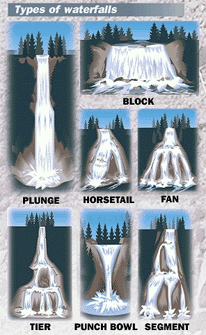
Which One AM I?
NOTE: In order to claim a find, post a photo of
yourself and GPS with the falls in the background and email answers
to the following questions: 1. From the above information and your
keen sense of observation, what type of waterfall is this?, 2. What
is your estimate of the width of the bottom of the falls ( jumping
in and using a tape measure is not required!) 3.What is the
elevation of the trail at this point and 4. What is your best guess
as to what type of sedimentary rock is the base of the
falls?
This Earthcache was approved by the
Geological Society of America
| We have earned GSA's highest
level: |
 |
Additional Hints
(Decrypt)
Gur uvag jnfurq njnl qbjafgernz!
Treasures
You'll collect a digital Treasure from one of these collections when you find and log this geocache:

Loading Treasures