I have always wondered why the Ten Mile Creek is named as such,
so I did a little bit of research into it. I was unable to find any
reason for the name, but I did learn a few new things while looking
up information.
The Ten Mile Creek is part of what is known as the Cedar/Ford
Watershed. There are two major rivers that make up this watershed,
the Ford River which flows into Lake Michigan south of Escanaba and
the Cedar River, which flows into Lake Michigan at Cedar River
(about halfway between Menominee and Escanaba. The Bark River is
also part of this watershed and meets the lake about halfway
between the two along with various other small streams.
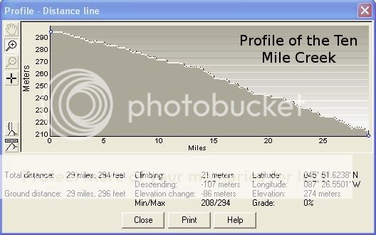
The Ten Mile Creek begins in the wetlands areas north and west
of La Branche, Michigan. From there it flows in a generally
southeast direction roughly following the M69 Highway. It flows
through Perronville and just to the north of Schaffer before
flowing into the Ford River about 2 miles northwest of Hyde. From
there, the Ford River drains into Lake Michigan. From beginning to
end if flows approximately 29 miles.
If you look to the north of the cache you will see a gauge
station.
