Buzzard's Rock on Whitetop Mountain EarthCache
Buzzard's Rock on Whitetop Mountain
-
Difficulty:
-

-
Terrain:
-

Size:  (not chosen)
Please note Use of geocaching.com services is subject to the terms and conditions
in our disclaimer.
Directions: US 58 from Damascus to the Whitetop Post office, turn
left on VA 600, head north for 1.5 miles, turn left on USFS-89.
Follow USFS-89 for about three miles to the parking area and the
trail head to Buzzard's Rock. Easy elevation change to
Rock.
Whitetop Mountain, like the nearby Grayson Highlands, has
prime examples of high country meadows commonly referred to as
'balds'. The views from these meadows, just below the summit ridge,
are among the finest in the Southern Appalachians. From these
peaks, one can stand and view such notable summits as Grandfather
Mountain and the slopes of Beech Mountain far off in the
distance.
Whitetop is part of the Mount Rogers chain. Whitetop is a
mountain summit in Grayson County Virginia . Whitetop climbs to
5,525 feet above sea level. This elevation makes Whitetop the
second highest peak in Virginia but it is also the highest peak in
Virginia that can be driven to.
It stands slightly apart from other places because of the treeless
'bald'. This appearance also makes it more eye-catching than nearby
Mount Rogers. Surrounding the'bald' you will find quite a variety
of habitat. This includes eastern and northern hardwood forests,
open meadows, birch and northern red spruce forests. To the side of
the 'bald', you will find the remarkable Buzzard's. Rock. The
Buzzard's Rock stands out among the sparse landscape.
The Earth is approximately 4.5 billion years old. In the
Southern Appalachians, the history of the last billion years is
recorded in the rocks. By reading the rocks, we can trace our
geological history. The rocks at the core of the Appalachian
Mountains formed more than a billion years ago. At that time, all
of the continents were joined together in a single super continent
surrounded by a single ocean. About 750 million years ago, the
crust of the super continent began to thin and pull apart. As the
crust expanded, a deep basin -- the Ocoee -- formed in what is now
the western Carolinas, eastern Tennessee, and northern Georgia.
Seawater filled this basin. At the same time that the sediments
were being laid down, volcanoes were erupting in present-day
Virginia, the Carolinas, and Georgia. Lava from some volcanoes
flowed in slow moving sheets with some explosive eruptions
occurring.

The Formation Of Igneous
Rocks
Unlike it northern neighbors, The Buzzard's Rock has been
formed by those volcanic actions. Because of the volcano, the rock
found here is primarily igneous and not sedimentary. Of the three
major groups of rocks, metamorphic, sedimentary and igneous,
igneous was/is formed by 'Fire' and it is commonly referred to as
magma or lava flow. The classification(s) of igneous rock can be
complex. Here is one simplified classification scheme:
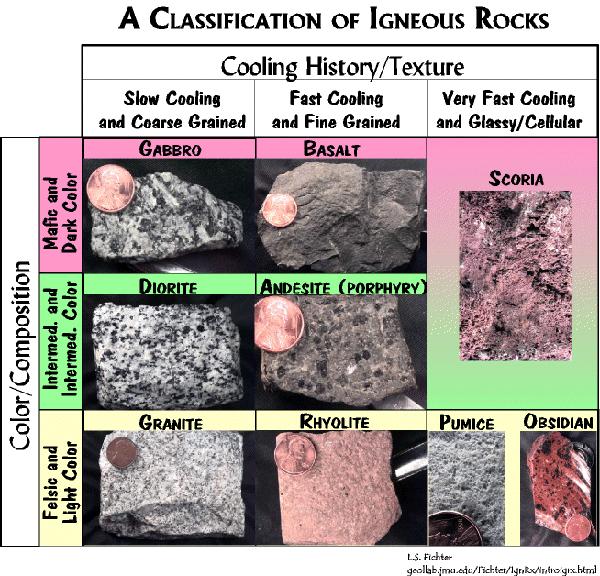
Igneous rocks are either intrusive or extrusive. Intrusive
are igneous rocks that were formed below the surface of the Earth
and did not 'erupt' onto the surface. Some examples of intrusive
igneous rocks are: granite, diorite and gabbros. These rocks are
course grained especially when compared to their extrusive
fine-grained cousins. On the other hand, extrusive rocks are formed
below the Earth's surface and 'erupt' onto the surface. Some
examples of extrusive igneous rocks are basalt, andesite and
rhyolite with rhyolite being the most commonly found rock on the
Buzzard's Rock peak. Rhyolite is considered to be the extrusive
equivalent to the plutonic granite rock and consequently
outcroppings of it often bear a strong resemblance to granite. The
Buzzard's Rock is largely rhyolite.

Ryolite
NOTE: In order for you to claim a find please post a
picture of yourself (entire party) with GPS in hand. Also make sure
that the Buzzard's Rock is in the background. Please email
us the answers to the following questions: 1. What is the elevation
of the Buzzard's Rock and 2. What are the predominant colors
of the rhyolite rocks found at Buzzard's Rock and 3. Estimate the
height of the Rock from the trail level.

Buzzard's Rock
We hope you enjoy the visit to one of the most geologically
interesting peaks in Virginia. Take your camera for far more
enjoyment than satisfying the photo requirements of the
cache.
This Earthcache was approved by the
Geological Society of America
| We have earned GSA's highest
level: |
 |
Additional Hints
(Decrypt)
Pebffvat 'byq onyql' jvyy abg znxr lbh tb onyq!
Treasures
You'll collect a digital Treasure from one of these collections when you find and log this geocache:

Loading Treasures