Fish Creek Gaging Station EarthCache
Fish Creek Gaging Station
-
Difficulty:
-

-
Terrain:
-

Size:  (not chosen)
Please note Use of geocaching.com services is subject to the terms and conditions
in our disclaimer.
This
EarthCache will take you to an automated USGS Gaging Station on
West Branch of Fish Creek; AKA Hiram Sweet Ditch. With a
drainage area of 37.5 square miles and is the discharge for Ball
& Hamilton Lakes to the west. This, the upper West Branch, has
been channelized to accommodate rapid drainage from the nearby
urbanized area as well as the overflow from the two morainal
lakes.
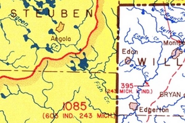
Fish Creeks primary stream
channel is ~30 miles long and drains a total of 110 square miles
agriculture watershed covering three counties, one in Ohio and two
in Indiana. The watershed begins in northeast Steuben and northwest
Williams counties and stretches south to northeast DeKalb county
and back into Williams county north of Edgerton. It discharges into
the St. Joseph river there. It's classified as a warm water stream,
with an average slope of 2.1 feet per mile. Most of the stream bed
is composed of sand and gravel deposits. (glacial
outwash)
Fish Creek has a diverse
wooded corridor that provides shade, food and shelter for fish and
wildlife and is among the top ranked biodiversity sites in the
Great Lakes Basin. The system harbors 31 species of mussels and 42
species of fish. (it's the
only known site, worldwide, for the White Cat's Paw Pearly
Mussel)
Fish Creek is located in
the physiographic zone known as the Steuben Morainal Lake Area.
Both the topography and physiography of the area were produced by
the activities of the Huron-Saginaw and Ontario-Erie lobes of the
Wisconsin ice sheet and subsequent post-glacial modifications of
the glacial landforms. The glacial landforms within this watershed
includes end moraines, ground moraines, kames, outwash plains,
valley train deposits, and dune deposits. Nearby lakes include Ball
Lake, Terry Lake, and the original several small morainal lakes
that were contained to form the 800 acre Hamilton Lake.
The areas uppermost bedrock is a black shale known as
Antrim Shale. This shale here is approximately two
hundred feet thick and was deposited in the ancient seas that once
covered the region. It has been a source of many pebbles and
cobbles in the areas glacial drift, and contains abundant levels of
pyrite (iron disulfide). The
average depths of glacial drift in this area is 300-400
feet.

The U.S. Geological Survey
(USGS) is the principal federal agency tasked with maintaining
records of natural resources. Within the USGS, the Water Resources
Discipline carries the responsibility for monitoring water
resources.
To establish a stream
gage, USGS personnel first choose a site on a stream where the
geometry is stable and there is a suitable location to make direct
measurements of streamflow using specialized equipment. Many times
this will be at a bridge or other stream crossing. Technicians then
install equipment that measures the stage and, more rarely, the
velocity of the flow. Additional equipment is installed to record
and transmit these readings to the Water Science Center
office where the records are
kept.
Automated Gaging
Stations
Most automated river gages
are maintained by the USGS. These gages record the river stage
every 15 minutes. Many of the gages are equipped with communication
devices that allow the NWS (and other State and Federal agencies)
to access "real-time" river data as needed.
Communication with these
automated gages is done in one of two ways. Many gages have a Data
Collection Platform (DCP) that is connected to the stream-gaging
equipment. The DCP stores the data from the gage and then transmits
the data through a geostationary satellite.
Other gages have a Limited
Automatic Remote Collector (LARC) installed that connects the river
gage to a telephone. Data from these sites is downloaded via a
modem, about once an hour.
Measurement of Discharge
Automated direct measurement of streamflow discharge
is difficult. In place of the direct measurement of streamflow
discharge, one or more surrogate measurements can be used to
produce discharge values. In the most cases, a stage measurement is
used as the surrogate. Shallow-sloped streams are influenced
by downstream channel conditions. For these streams, a second
stream gage would be installed, and the slope of the water surface
would be calculated between the gages. This value would be used
along with the stage measurement to more accurately determine the
streamflow discharge.
In those instances where
only a stage measurement is used as the surrogate, a rating curve
must be constructed. A rating curve is the functional relation
between stage and discharge. It is determined by making repeated
measurements of streamflow discharge using a velocimeter and some
means to measure the channel geometry to determine the
cross-sectional area of the channel. The hydrologists responsible
for determining the rating curve visit the site routinely, with
special trips to measure the hydrologic extremes (floods and
droughts), and make a discharge measurement by following an
explicit set of instructions.
Once the rating curve is
established, it can be used in conjunction with stage measurements
to determine the volumetric streamflow
discharge.
To view the realtime data
for this station and to log this EarthCache, go
here.
Then answer the following
questions in an email to me:
1. What type of communications device is
used here? DCP or LARC?
2. What were the rate of discharge
and staging level at the time of
visitation?
3. Give an estimate of the width of
the stream at this location.
Additional Hints
(Decrypt)
[Please post no photos that may disclose the requested information.]