From the guidelines, as from January 2013: "People do not need to wait for permission to log your EarthCache. Requiring someone to wait is not supported by the EarthCache guidelines. People should send their logging task answers to you, then log your EarthCache. When you review their logging task answers, if there is a problem, you should contact them to resolve it. If there is no problem, then their log simply stands."

Introduction: More than half the world’s population lives in coastal regions, and many people visit the coast frequently. Most come for seaside recreation, but some also wonder about the origins of coastal scenery. A walk along the shore or a coastal footpath prompts questions about how such features as cliffs, rocky outcrops, beaches and dunes formed, and how and why they are changing. Coastal geology is concerned with the rock formations and structures seen in cliff and shore outcrops, and the sediments that have been deposited in coastal regions. It provides the background for coastal geomorphology. Coastal geomorphology deals with the shaping of coastal features (landforms), the processes at work on them and the changes taking place.
Apart from incidental comments by classical Greek and Roman observers and by Leonardo da Vinci, the first systematic attempts to explain coastal landforms were by 19th century scientists such as Charles Lyell and Charles Darwin, and the pioneer American geomorphologist William Morris Davis.While a great deal of work was done in the 20th century on various parts of the world’s coastline, particularly in Europe and North America, it is only in the past few decades that coastal research has become widespread, and there is still plenty of opportunity for original contributions (After Bird, 2008).
Pedra da Ursa: Is for all intents and purposes
a large, pyramidal-shaped limestone outcrop in the Atlantic ocean close to Cabo da Roca. It is said that it resembles the shape of a huge bear facing the skies when viewed from the northern side. Legend has it that it is a mother bear that disobeyed the gods by refusing to migrate northwards without her cubs as the Ice sheets started to melt over the Sintra Mountains. The irate gods turned the bear to stone and her cubs into smaller boulders forever scattered around her. The local beach, known as the Ursa Beach, takes its name from this striking coastal feature.
Immediately to the north is another equally unusual formation called "Pedra da Noiva" (Bride's Stone).
Stacks: Features such as Pedras da Ursa and Noiva are normally known as stacks (residual islets). Stacks, like chimneys, are solitary features stretching straight up and normally form as a result of the dissection of promontories on a cliffed coast They can form either where a natural arch has collapsed, or where a transverse inlet has been cut along a zone of weakness through the headland. They are gradually reduced by marine erosion, and may be undercut until they collapse, leaving only a basement platform. Stacks occur off many cliffed coasts.
See the following sequence of pictures for a clearer understanding of the concept.
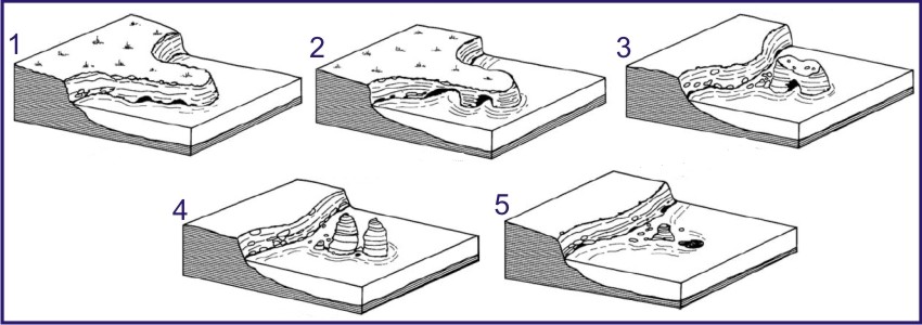
The Ursa Stone is currently at stage 4 as per the images above
(Images adpted from Bird, 2008). Pedra da ursa is also a climbers paradise and many are those that climb it. If you want more information on this aspect visit
this site and check out
this Blog.
The EarthCache:Three-quarters of the world’s coastline is cliffed and rocky.This EC takes you to a rocky shoreline that has been shaped by both geological forces as well as marine processes and where you can observe stacks of breathtaking beauty. The area is a photographers haven so do take your camera along.
In keeping with the theme, your task in order to log this find is to tell me 1- how many large stacks you see and 2- how many smaller stacks you can see on the southern side of Pedra da ursa, i.e. how many cubs have the gods turned to stone (note that high tide may alter the number so I'll be leniant).
This cache has a sister cache called URSA by BTRodrigueswho has been contacted and has given permission for the placement of this EarthCache - Thanks BT. I strongly suggest that you use his waypoints for the access points to the area and read the information on the fauna and flora of the area.
Sources:
Bird, E, 2008. Coastal Geomorphology: An introduction. John Wiley and Sons, Ltd.
Sintra Digital

A Pedra da Ursa: Localizada a poucas centenas de metros a norte do Cabo da Roca afloram dois gigantescos rochedos (a Pedra da Ursa e a Pedra da Noiva) que se destacam no meio de muitas outras. A Praia da Ursa adjacente deve o seu nome segundo a lenda, a uma ursa que desobedeceu às ordens dos deuses, recusando-se a migrar para Norte com os seus filhotes quando os gelos que cobriam a Serra de Sintra começaram a derreter. Iradas, as divindades transformaram a ursa desobediente numa enorme pedra e os filhotes em pequenos calhaus para sempre dispersos em seu redor.
A Pedra da Ursa é um típico stack. Um stack, tal como uma chaminé, é um rochedo solitário que se forma devido à dissecção de promontórios numa linha costeira com falésias. Os diagramas em baixo indicam um provável mecanismo para a sua formação. Eventualmente, devido à erosão marinha, sobrará somente uma plataforma basal. A Pedra da Ursa, tal como o diagrama indica, está neste momento na fase 4 dos diagramas apresentados.
A EarthCache: Para poderem logar esta cache vão ter que me dizer quantos stacks grandes estão na zona e quantos pequenos estão imediatamente a sul da Pedra da Ursa, ou seja, quantos filhotes as divindades tornaram em pedra.
Esta cache tem uma cache irmã : A URSA do BTRodrigues ali ao lado e o qual deu a sua autorização para a implantação desta EC – Obrigado BT. Aconselho a leitura da sua página e o uso dos seus waypoints.

 The most exciting way to learn about the Earth and its processes is to get into the outdoors and experience it first-hand. Visiting an Earthcache is a great outdoor activity the whole family can enjoy. An Earthcache is a special place that people can visit to learn about a unique geoscience feature or aspect of our Earth. Earthcaches include a set of educational notes and the details about where to find the location (latitude and longitude). Visitors to Earthcaches can see how our planet has been shaped by geological processes, how we manage the resources and how scientists gather evidence to learn about the Earth. To find out more click HERE.