30000 Islands Archipelago EarthCache
30000 Islands Archipelago
-
Difficulty:
-

-
Terrain:
-

Size:  (other)
Please note Use of geocaching.com services is subject to the terms and conditions
in our disclaimer.
-- THIS IS AN EARTHCACHE, READ BELOW FOR LOGGING REQUIREMENTS --
The Eastern coast of Georgian bay is dotted with thousands of glacier smoothed granite islands that make up the southern edge of the Canadian Shield. The regions freshwater basin makes it unique, but the area resembles 3 other ecosystems on earth: The islands of Puget Sound in British Columbia, Baltic Sea coast east of Stockholm, Sweden, and the north eastern coast of Maine.
Although the region is known as the 30000 islands, there is estimated to be more then 40000 ranging in size from above water boulders to thousands of acres.
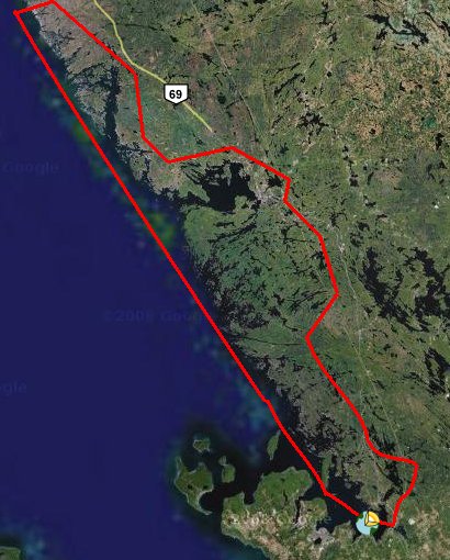
region highlighted in red is known as the 30000 islands
The Native Hurons of the region had a legend of an angry giant named Kitchikewana who was responsible for making the islands. He was so angry that the other Huron gods gathered all the most beautiful women from the tribes in an attempt at calming him down through love. He did end up falling in love with one woman, but she did not want to be with him as she already had a boyfriend. This made him even angrier, he dug his mighty hands into the dirt around her village and tossed it all into Georgian bay (creating the many islands). He was so sad he then fell asleep in the bay and exists as the giants tomb off the coast of Penetanguishene. His claw marks make up the 5 bays of the Huronia region; Midland Bay, Penetang Bay, Hog Bay, Sturgeon Bay, and Matchedash Bay.
The geologic story sees things a little differently - These islands make up the southern edge of the Canadian Shield. Severn Sound is actually formed by the edge of the volcanic rocks of the Canadian Shield to the north and sedimentary rocks and limestones of the Saint Lawrence lowlands to the south. To the north, the land has been stripped down to the bedrock by retreating and advancing glaciers over the last few million years. The islands are smooth, rocky and numerous, while to the south the islands are sandy. The Canadian shield does extend all the way to Texas, but dives deep underground beyond this point.
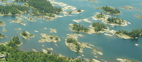
Most of the islands are smooth granite above the lake
The Canadian shield is the exposed part of the North American Continental shelf (or "Craton"). It contains the oldest known rocks in the world, and was likely the earths first continent. The Shield contains a common joined bedrock stretching from this point all the way to the tip of Ellesmere island and Greenland near the north pole, from Newfoundland to Alberta.
The Archipelago is the worlds largest freshwater archipelago, one of only 13 UNESCO world biosphere reserve in Canada. It covers 347,000 hectares of sparsely populated shoreline ecosystem, over 100 species of animal and plants that are at risk, including unique amphibians and reptiles such as the Massasauga Rattlesnake. Although the age and makeup of the rocks along the coast varies, most of the islands are made of Pink and Black Granite which is common throughout the region.

Smooth Granite beaches have formed due to billions of years of erosion
Photo thanks to Ken Lewis
TO LOG THIS EARTHCACHE:
- ADD TO FOUND LOG - Take a photograph of yourself at the listed coordinates showing islands in the lake
- ADD TO FOUND LOG - Name 3 islands in the 30,000 islands archipelago using Topographical maps. Find 3 island names that have not been used yet in previous log entries!

Click the logo to visit the COG website!
Additional Hints
(No hints available.)
Treasures
You'll collect a digital Treasure from one of these collections when you find and log this geocache:

Loading Treasures