The online freedictionary.com defines a geologic unconformity as "A surface between successive strata representing a missing interval in the geologic record of time, and produced either by an interruption in deposition or by the erosion of depositionally continuous strata followed by renewed deposition."
The gap represents an interval of time that has left no record, either because nothing was deposited or because the rocks that were there have eroded away.
Some gaps are insignificant – think of a river eroding a mudhole, which then fills in with new sediments. Other gaps can be huge, spanning millions or billions of years.
A well-known unconformity that occurs throughout Colorado is known as the Great Unconformity. The phrase was originally coined by John Wesley Powell on his trip through the Grand Canyon in 1876. He noticed that in many places, undeformed sedimentary rocks younger than 600 million years had been deposited on top of metamorphic rocks that were much older.
That same pattern holds for Colorado. The older rocks in Colorado are igneous and metamorphic rocks more than a billion years old. The ones we see today probably formed at least 10km below the surface. On top of these old rocks are much younger sedimentary rocks. In some places, the contact between the crystalline basement rocks and the younger sedimentary rocks is well exposed.
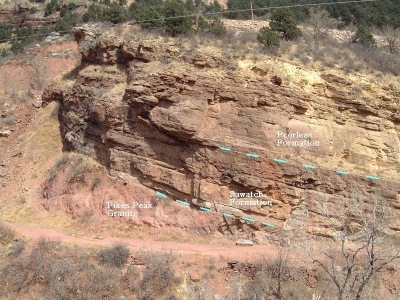
One of the exposed examples of the Great Unconformity may be found in Manitou Springs and is the subject of this earthcache.
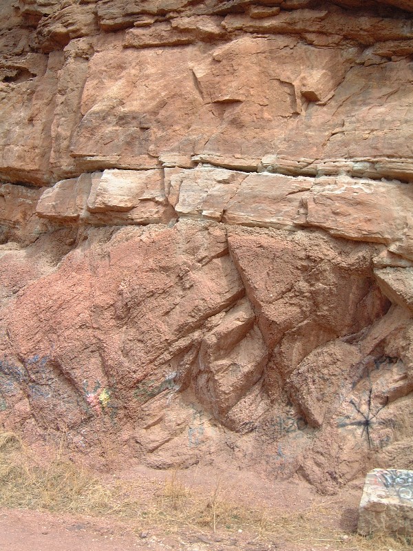
The unconformity in the Manitou Springs area does not span as much time as it does in some places. Here one sees the contact between the Pikes Peak batholith and the late Cambrian Sawatch Formation. The Pikes Peak granite has been age-dated to be about 1.1-1.2 billion years old, relatively young among the basement rocks of Colorado. The Sawatch Formation is roughly 500 million years old, as determined by its fossils. So, the gap here is “only” 600-700 million years. In some parts of Colorado, rocks that are 300 million years old or less lie directly on rocks that are 1.6-1.7 billion years old.
Imagine what happened in that interval. The granite batholith was approximately 10km underground 1.1 billion years ago. What happened in the intervening 600 million years? What might have been deposited? What was in the 10km that eroded away? There’s a lot of history missing. All of that time and history is represented in a contact you can span with your hand.
By the time these rocks were deposited, the granite had worn down to a fairly flat and even plain, close to sea level and not far from the western margin of North America as it existed then. The Sawatch Formation represents beach sands of a shallow tropical sea long ago. Most of the best exposures occur west of the Front Range. On the east side of the Front Range, it is mostly eroded away. Some of the best remaining outcrops on this side of the mountains occur near Manitou Springs.
Above the Sawatch Formation are the remnants of the Peerless Formation and the limy muds of the Manitou limestone, recording deeper water levels in that tropical sea. Trilobites and brachiopods are among the fossils one finds in these rocks. Another uncomformity exists where the Peerless Formation eroded before the Manitou Limestone was deposited, but it is not as dramatic as the juxtaposition of Pikes Peak granite and Sawatch sandstone.
 To log this cache, visit the site and answer the following questions in an email to the owner. Do not post the answers in your online log.
1. Email me a description of how the Pikes Peak Granite layer differs from the Sawatch Formation. You might mention color, layering, grain size, and any crystals you see.
2. The contact line is slanted and the angle from horizontal is called the "dip". Estimate the apparent dip of the contact at the listed coordinates.
3. Estimate the thickness of the Sawatch formation at this location. See the annotated photo for help identifying the contacts.
4. In your online log, post a photo of yourself, your party, and your GPS, with the Great Unconformity in the background.