***Please note: At one time, there was a sign providing information about the site. I paid for a new metal sign after the orginal had been destroyed. The new one was poorly installed and did not last a year, unfortunately, and the U of I, which is in charge of maintaining the preserve, did not replace it. Please use information provided below to answer the three questions. *** The preserve is located near Coralville Lake in east central Iowa. To get to the preserve from the west, take county road F-28 east from Highway 965. Continue until you cross the lake on the Mehaffy Bridge. Park on the shoulder near the intersection of F-28 and Sugar Bottom Road. There is more space on the shoulder closest to the lake, but be careful crossing the road! To get to the trailhead, go to:
N 41º 46.558 W 91º 33.489
Look for the preserve sign and follow the trail up the hill. In warm weather, there may be poison ivy along the trail so use caution. Please use the established trail to avoid damaging the fragile roadcut.
***Please note: This preserve is a multi-use area. The earthcache will not be available from September 15th through Thanksgiving due to ongoing research of migratory birds.
---Please honor these dates.---
In addition, a bird blind is also located on the property. This belongs to the Macbride Raptor project and should be left alone. Thank you.
Continue on the trail to the following location:
N 41º 46.576 W 91º 33.427
History
The area you are in has undergone many changes throughout Iowa's geologic past.
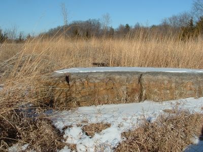
Although the lake is man-made, much of what you see was created as the result of major events in Iowa's geologic past. Two of those events are in evidence at Stainbrook. First, look closely at the large rock outcrop you have located in the middle of this relatively small, flat prairie. What color is it? Is it shiny and smooth or rough? Do you notice anything in the rock? This is a type of sedimentary rock called limestone. It was formed as part of a large group of bedrock known as the Cedar Valley limestone formation. This rock was formed millions of years ago when the area was covered by a warm, inland sea in what is known as the Devonian period. The climate was tropical and this sea was filled with life. Looking closely at the rock, you should be able to identify what appear to be small seashells, which are called brachiopods. Down by the lake and along the roadbed below the prairie you will find examples of many kinds of fossils from this time period.

Now look at the top of the large slab of rock. You will notice that it is pretty flat and smooth on top. You should also notice that there are long grooves that run the length of the rock. These "scratches" are called glacial striations. Can you guess what caused them? Long after the seas retreated, the earth went through cycles of warming and cooling, which continue to this day. During the cooler periods, large sheets of ice known as glaciers grew to enormous size. Several times the glacial ice was large enough to cover parts of Iowa, all the way south from the north pole. These "Ice Ages" have been given names as you can see in the following diagram.
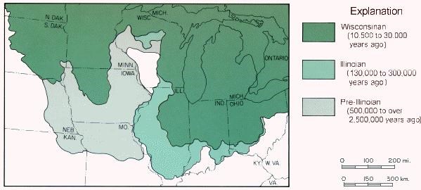
(Image courtesy of the Iowa DNR)
As the ice grew and moved, it scraped beneath it many small rocks. As the glacier moved, the small rocks below it would scrape and grind anything that lay under the glacier. In this case, they wore grooves in the limestone. This provides us with a unique record of the movement of the glacier. After the glacier moved on, fine silt from the scraped earth blew into mounds, creating the hill to the east behind you. Some of this earth was removed during the construction of the bridge and this large rock was discovered in the process.
Your tasks:
1) The grooves in the rock show the direction of travel of the glacier as it moved over this area. What was the direction of the glacier as it moved over this area?
2) The fossils you see were left from the Devonian period of time. How many million years ago, approximately, were the fossils formed.
3) Use the chart above to tell which glacial period was involved: Wisconsonian, Illinoian, or Pre-Illinoian.
Email me your answers to earn credit for this earthcache. Do not put them on your log.
For more information on the Stainbrook Preserve and the fossils present there,please visit:
http://www.cs.uiowa.edu/~jones/natural/stainbrook.html
For information on Iowa's glacial past, visit:
http://www.igsb.uiowa.edu/Browse/glatrail/glatrail.htm
Thanks to the Iowa DNR for providing information and the use of their glacial graphic:
http://www.iowadnr.gov/