Mill Creek Marsh
Hours: Wednesday – Sunday 6am–7pm. Closed
when snowing or snow covered. Closed Mondays and Tuesdays for
maintenance.
Directions: You can reach Mill Creek Marsh by taking
Route 3 to the to Mill Creek Mall and parking next to the Sports
Authority.
What is a Wetland?
Wetlands are lands that are flooded or saturated at or near the
ground surface for varying periods of time during the year. Wet
habitats generally occur between uplands and deepwater. Based on
their characteristics wetlands are further defined as marshes,
swamps, bogs, fens, wet meadows, etc.
Hackensack River Wetlands (Meadowlands)
The Hackensack Meadowlands are contained within the Northern
Triassic Lowlands (Newark Basin) of the Piedmont physiographic
province in northeastern New Jersey. The underlying bedrock is
Triassic red shale and sandstone formed when sediments were
deposited in the rift valley that occurred in this area 200 million
years ago. The Hackensack River valley, in which the Meadowlands
occur, is separated from the Passaic River valley to the west by a
low ridge of sandstone, and is separated from the Hudson River to
the east by a narrow ridge of igneous rock (Palisades diabase or
traprock). A few outcroppings of traprock occur at Laurel Hill and
Little Snake Hill in Secaucus. The elevations of wetlands in the
Meadowlands range from sea level to about 3 meters (10 feet) above
sea level, with bedrock outcrops at Laurel Hill rising to about 45
meters (150 feet) and several landfills rising to about 30 meters
(100 feet). The formation of the Hackensack River wetlands
commenced 8,000 to 10,000 years ago when the last glacial advance
began to melt and retreat northward. The terminal moraine of the
glacier created a large inland glacial lake (Glacial Lake
Hackensack) that persisted for several thousand years. Peat and
muck soils now overlay the lake sediments and glacial till.
Wetland Function & Value
Wetlands provide a habitat for plants and animals and breeding
grounds for fish. They filter water, provide opportunities for
people to observe, learn about, and enjoy wildlife. They also help
manage flooding and soil erosion. Tidal wetlands are transitional
areas between upland and marine environments. They tend to be damp,
muddy, filled with animals and insects. At one time people
perceived no direct need for the wetlands in the Meadowlands. Early
settlers and 19th century residents sought to fill in the swamps
and dike the creeks to make the land suitable to their purposes.
Thus began the process of wetland loss and degradation.
Flora & Vegetation (Hackensack Meadowlands)
The Hackensack Meadowlands is a large wetland complex dominated
by intertidal and intermittently flooded common reed (Phragmites
australis) marshes and lesser areas of the following wetland types:
shallow tidal bay/mudflat; low salt marsh dominated by low marsh
cordgrass (Spartina alterniflora); remnant high salt marsh
dominated by high marsh cordgrass (Spartina patens); brackish
impoundments; freshwater impoundments; and remnant palustrine
forest dominated by pin oak (Quercus palustris), red maple (Acer
rubrum), and swamp white oak (Quercus bicolor). Grassland,
shrubland, and early successional forest are the upland habitat
types on the landfills, with small undeveloped uplands scattered
around the edge of the Meadowlands.
It is extremely useful to understand the vegetational history of
the Meadowlands in order to understand the changes that have taken
place in recent and historical times and the potential goals for
restoration. Pollen and peat samples from the Meadowlands indicate
a sequence of vegetational communities following the draining of
the Glacial Lake Hackensack from black ash (Fraxinus nigra) swamps,
to northern bogs with larch (Larix larcinia) and black spruce
(Picea mariana), to Atlantic white cedar (Chamaecyparis thyoides)
swamps and, finally, to brackish marshes typified by threesquare
bulrush (Scirpus americanus), black grass (Juncus gerardii), and
narrow-leaved cattail (Typha angustifolia). By the time the first
settlers arrived in this area in the 1600s, the Hackensack
Meadowlands were predominantly a freshwater tidal river system,
with Atlantic white cedar swamps occupying much of the wetland
system and northern bogs occurring in other areas. Almost
immediately after their arrival, the settlers began to change and
control the hydrology of the Meadowlands -- first for agricultural
purposes, then for industrial purposes and, in the early part of
the 20th century, for mosquito and flood control. It was the
mosquito control activities of diking, ditching, and tidegating,
along with natural processes, especially sea level rise, that
drastically altered the wetland diversity, leading eventually to
the destruction of the cedar swamps and the concomitant invasion by
common reed, which in many areas has become a dense monoculture. In
1922, a dam was constructed on the Hackensack River in Oradell,
cutting off most of the freshwater flow to the Meadowlands and
allowing brackish water to intrude further upriver. In recent
decades, filling of wetlands in the area has reduced their extent
from about 8,100 hectares (20,000 acres) to about 3,400 hectares
(8,400 acres).
Wetlands Enhancement
Wetlands enhancement can be defined as any activity that
restores a wetland degraded by human activity to a healthy,
functioning ecosystem. These activities may include the restoration
of appropriate hydrology, the creation of specific habitats, the
control of invasive plant species, and the reintroduction of native
marsh vegetation as shown above. The actual enhancement activities
may include the eradication of the invasive Phragmites australis
and the establishment of a vegetative mosaic by replanting more
desirable plant species as well as creating meandering channels to
increase habitat and restoring tidal flow to the site.
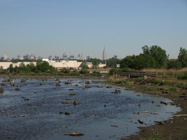
Mill Creek Enhancement Site
The Mill Creek Enhancement Site comprises Mill Creek Marsh and
Mill Creek Point Park, encompassing approximately 225 acres along
Mill Creek, a tributary to the Hackensack River. Like many other
sites in the Meadowlands District, this area was altered by human
activity beginning in the 19th Century and lasting into the latter
part of the 20th Century. Diking and draining of the wetlands
contributed to a decrease in the flow of tidal water and a loss of
important vegetation. The New Jersey Meadowlands Commission
acquired the marsh in 1998 and began wetland enhancement
activities, and the results have been dramatic. Migratory
shorebirds can now be found, along with a variety of waterfowl that
use it for breeding and feeding. Thousands of Green-winged Teal
have been counted. Herons, egrets, and cormorants actively fish in
the marsh, while raptors, hawks and osprey can be seen soaring
overhead. There are two large impoundments within the Mill Creek
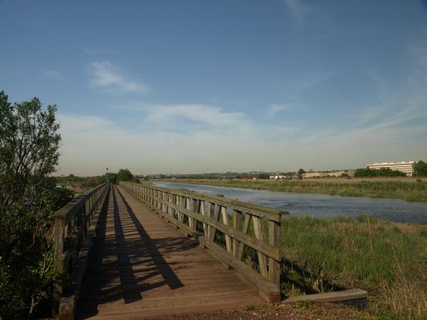
site, along with channels, mudflats, and upland areas. You can
explore the Mill Creek Marsh on foot or by small watercraft. The
entrance to the Mill Creek Marsh Walking Trail is near the southern
portion of Mill Creek Marsh adjacent to the Mill Creek Mall.
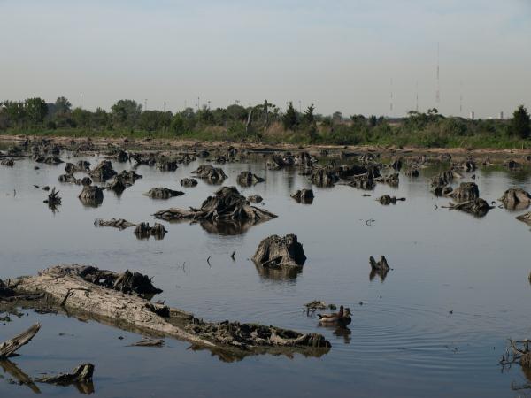
Mill Creek Marsh Walking Trail
Along the Mill Creek Marsh Walking Trail, you can't miss the
“forest of stumps” — evidence that the
now-brackish Meadowlands was once a freshwater swamp covered by
dense thickets of Atlantic white Cedar. The advent of European
colonization changed the landscape forever. Centuries of systematic
logging were only exacerbated by the completion of the Oradell Dam
in 1923, which allowed the influx of saltwater into the lower river
that killed the last remnant cedar groves and allowed common reed
to spread throughout the Meadowlands. An unexpected result of
wetlands mitigation at Mill Creek Marsh was the unearthing of
hundreds of Atlantic White Cedar stumps, some of which are hundreds
of years old.
More than 260 bird species have been reported in the
Meadowlands, a major stop along the Atlantic Flyway. Within the
Mill Creek Marsh, Green-winged Teal frequently congregate in open
water and use phragmites as a wind break from cold winter winds.
The return of spring is heralded by Tree Swallows seeking homes in
nest boxes built by the NJMC and volunteer groups. In the summer,
Double-Crested Cormorants perch atop the remains of dilapidated
docks and tide gates, Herons, Egrets and Terns feed along
shorelines, and Black-crowned Night Heron, a threatened species in
New Jersey, nest in the taller trees. Fiddler Crabs dig in along
the riverbank. Diamond-back Terrapin can be seen in shallower
waters, and Muskrat huts rise above the land.
Reference:
New
Jersey Meadowlands Commission
Hackensack
Meadowlands
Urban Habitats
Logging Requirements:
- Take a picture with GPS anywhere on the Mill Creek Marsh Trail
with the Atlantic White Cedar stumps clearly visible in the
background.
- With further wetlands enhancement do you think it would be
possible for Atlantic White Cedar to thrive once again?
- The elevation of the wetlands in the Meadowlands ranges from
about 3 meters above sea level to about 45 meters above sea level.
What reading to you get on the trails?
- While on the trails please use the signs to identify wetlands
vegetation & wildlife. What did you identify?
All answers should be emailed to the cache owner. Feel free to
post any pictures!
Picture Examples
 |
 |
 |
| Picture 1: Mill Creek Marsh |
Picture 2: Atlantic White Cedar Stumps |
Picture 3: Wetland Bridge |