Mosquito Beach
Permission for this Earthcache was granted by the
Pictured Rocks
National LakeShore Park Service because of Earthcache's
Leave No Trace principles, and the fact there is no
placement of any physical cache container. Having a cache container
placed anywhere within Park boundaries is prohibited.
Directions Mosquito Beach and Mosquito Falls are located about
15 miles east of Munising off Alger County Road H-58, then about 5
miles north to the parking area at end of Chapel Road. Park and
follow the trail signs in.
NO PETS are permitted along any trail within Pictured
Rocks National Park.
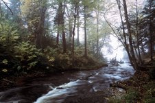
 Mosquito Beach is aptly
named, particularly in May and June. Once the mosquitoes die
off however, this location becomes a very interesting
geological waypoint. Nestled in an interruption of the
Pictured Rocks cliffs east of Miners Beach, Mosquito Beach is
a beautiful place with an interesting human and geological
history.
Mosquito Beach is aptly
named, particularly in May and June. Once the mosquitoes die
off however, this location becomes a very interesting
geological waypoint. Nestled in an interruption of the
Pictured Rocks cliffs east of Miners Beach, Mosquito Beach is
a beautiful place with an interesting human and geological
history.
Mosquito River enters Lake Superior here (posted
Coordinates), and hikers and boaters can see the intersection of
two of the Lakeshore’s main bedrock formations. These are the
Chapel and Miners Castle members of the Munising
Formation. The contact point lies just above the water line
on the shelves of rock to the northeast of the river mouth.
The Chapel is a pinker layer and the
overlying Miners Castle a lighter, whiter
layer.
From the mouth of Mosquito River as you walk along the bedrock lake
edge toward the point of rock, you begin to see
Giant Ripple casts in the
sandstone. This bedrock is the lower portion of the
Miners Castle member of the Munising
Formation. The ripple marks were laid down when the
sediments were deposited in a warm, shallow ocean. At that time
this region was near the equator and life as we know it had not
emerged from the ocean onto land. The Cambrian terrestrial
environment uninhabited and was very inhospitable with acid rain
and warm, humid temperatures. Trilobites cruised the shallow ocean
bed.
To the west of Mosquito River bedrock reveals other interesting
features. Rain drop impressions can be
seen in some bedrock locations at the west end of the beach. The
thin layers of sandstone also have mud cracks preserved in stone
where mud puddles dried and the mud cracked as it dried out, later
being covered with additional sediments.
 In terms of landscape, Mosquito
River is part of a larger system of valleys gouged out of
bedrock as the most recent episode of glaciation occurred.
Looking at a topo map (pictured right), you can see the long
arc of an ancient valley that sweeps to the southeast from the
river mouth. The valley connects with the Chapel Basin which
is another of these large post-glacial river systems, as is
the Beaver Basin.
In terms of landscape, Mosquito
River is part of a larger system of valleys gouged out of
bedrock as the most recent episode of glaciation occurred.
Looking at a topo map (pictured right), you can see the long
arc of an ancient valley that sweeps to the southeast from the
river mouth. The valley connects with the Chapel Basin which
is another of these large post-glacial river systems, as is
the Beaver Basin.
These channels were eroded as post-glacial rivers rampaged through
the region some 9500 years ago. Rivers of icy water, perhaps filled
with rock and gravel, carved this valley. Today it drains north,
but at the time it drained southeast.
Mosquito Beach is also known for its human history.
Most notably, in November of 1940, the steamer Sparta ran aground
here and spent the winter hauled up on the bedrock shore. The U.S.
Coast Guard from Munising responded to the accident and all hands
were safely removed from the ship. The Sparta was towed off the
reef that next spring.
 Mosquito River is known
for its steelhead trout runs and native brook trout. In recent
years, the National Park Service, U.S. Fish and Wildlife
Service, and Michigan Department of Natural Resources have
collaborated to reintroduce Coaster Brook Trout, a larger
native lake run variety of the brook trout.
Mosquito River is known
for its steelhead trout runs and native brook trout. In recent
years, the National Park Service, U.S. Fish and Wildlife
Service, and Michigan Department of Natural Resources have
collaborated to reintroduce Coaster Brook Trout, a larger
native lake run variety of the brook trout.
There are 3 requirements that you will need to
complete for this Earthcache in order to log it as a Find.
You will need to bring a Camera & Thermometer with
you.
1), Post a picture of Your Face, with
Your GPS, at Mosquito Beach clearly showing the Mosquito
River & Lake Superior in the background of the
picture.
This picture is required, and at the time of your log entry.
2), Take a temperature reading of the Mosquito
River water, and a nother from the beach sand at least 50 feet away
from the water, Subtract the two temperature readings, and post
your answer with your log entry.
3), From where the Mosquito River empties into
Lake Superior, walk east around the OutCropping in a clockwise
direction. On the other side of the OutCroppings is where you will
find one example of the Fossilized Giant Ripples. What is the color
of these Fossilized Ripples in this location. Do not post this
answer in your log entry, but email me the color directly through
my Profile.
The picture is required, and at the time of your log
entry.
