Roche-A-Cri: Glacial Lake Wisconsin
The park road is a short loop and there is parking available at several locations. Winter Parking can be found at: N43 59.777 W89 49.039. Please use due caution if planning a winter visit as your hike will be longer, ski trails must be avoided and the steps and trails may be icy. The accent to the observation deck in winter is not recommended. The foot bridge from the winter parking area may be subject to high water. Dogs are not allowed up to the observation deck.
To log this cache you will need to email me the answers to some questions.

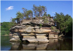
You are standing on what was once the bottom of a great lake. Glacial Lake Wisconsin was a short-lived prehistoric glacial lake that existed from approximately 19,000 to 15,000 years ago, at the end of the last Wisconsin ice age. The lake was located in the "central sand plains" ecoregion of the state. This portion of the state is generally a flat, sandy lake plain which was formed in and around Glacial Lake Wisconsin. The soil here is primarily sandy lake deposits. Sandstone buttes carved by rapid drainage of the glacial lake, or by wave action when they existed as islands in the lake, are distinctive features of this landscape.
The lake began its formation when ice from the Green Bay Glacial Lobe came into contact with the Baraboo Hills in southwestern Wisconsin. This contact blocked the south-flowing Wisconsin River and due to higher topography on the lakes other margins it continued to fill fed by meltwater from the Wisconsin River. At its peak Glacial Lake Wisconsin was up to 150 feet in deep and covered over 1,825 square miles. Today lake deposits are covered in many places by glacial outwash, dune sand, peat and muck. Many of the swamps, marshes and bogs of central Wisconsin were formed as a result of the accumulation of the Lake's more impervious deposits after the last glaciation.
|
| The eventual bursting of an ice dam from retreating glaciers released the lake and caused a catastrophic flood which redirected the Wisconsin River and formed the Wisconsin Dells (a deeply cut 5 mile gorge). This flood lowered the level of the lake from 150 feet to approximately 50 ft in a period of only a few days. |
Logging Requirements:
1. Email me a description of the soil found throughout the park.
Email me the answers found at the listed coordinates.
2. The flat plain is the old bed of Glacial Lake Wisconsin, which covered __________ square miles...
3. …of central Wisconsin some ___________ years ago.
Uploading pictures to the cache page is the best way to thank an EarthCache developer and to encourage others to visit.
Sources & Permission:
http://dnr.wi.gov/landscapes/
http://en.wikipedia.org/wiki/Glacial_Lake_Wisconsin
http://adsabs.harvard.edu/abs/2001AGUFMIP52A0756C
http://www.wisconline.com/wisconsin/geoprovinces/centralplain.html
Permission for this listing has been granted by Thomas A. Meyer, Conservation Biologist, State Natural Areas Program, Bureau of Endangered Resources, Wisconsin Department of Natural Resources. Prior to placing a geocache on state land one must submit the DNR Geocache Notification Form to the appropriate land manager: http://www.dnr.state.wi.us/org/land/parks/other/pdfs/form2500-118.pdf