Welcome to
Fort Frederick State Park
...Maryland's Very
First State Park
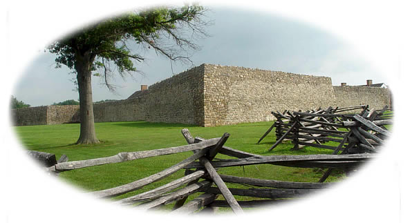
Fort Frederick was the cornerstone for Maryland’s frontier
defense during the French and Indian War (1754-1763). The stone
fort was named in honor of Frederick Calvert, the sixth Lord
Baltimore. It is unique because of its large size and strong stone
walls. Most other forts of the period were built of wood and
earth.
The fort served as an important supply base for the English
campaigns and its presence brought stability to the area following
years of raids by the French and Indians. Lesser roles were played
by the Fort during the Revolutionary and Civil Wars, and for 131
years, the Fort was owned by citizen farmers.
Public interest in the site prompted the State to re-acquire the
Fort in 1922. In the gloom of the Great Depression in the
1930’s, the Civilian Conservation Corps worked wonders on the
the collapsing and missing sections of the fort wall.
But all of that is fully explained in detail at the interpretive
sites you will encounter as you work through the virtual stages
around the Park. Park camping, picnic, re-enactment and activity
information is available at the link above the picture. There are
no fees for park entry. However, after April 1st, entry into
the Fort itself is $3 for adults and $2 for children ages 6-12.
General Park hours are :
November 1 – March 31: 10:00 am - Sunset
April – October 31: 8 am - Sunset
The Fort predates two other local attractions that highlight the
westward expansion of America. The C&O Canal traverses the Park
adjacent to the Potomac River. Less than a mile away, upriver, is
the eastern terminus of The Western Maryland
Rail Trail (WMRT) which follows the right-of-way of the old
Western Maryland Railroad.
The cache you seek is a Virtual-Multi. You will visit four
distinct places on Park grounds, gathering pertinent information at
each with which to build a set of coordinates for your final
destination. Easily completed in less than an hour, you are
encouraged to absorb not only the eye-pleasing natural and physical
beauty of Fort Frederick, but also three centuries of rich
history.
Final Coordinates - N 39* 36. C A M, W 078* 00. W M D
C - Published coordinates will place you at a bronze
marker. C is the second digit of the only number displayed
on the marker.
A - Proceed close-by to N 39* 36.557, W 078* 00.229.
A is the number of signs on the front porch that point to
something other than the “CCC Museum."
M - Proceed to N 39* 36.617, W 078* 00.290. Note the
mortar and log construction that was common on the colonial
frontier. Facing the Shop, M is the number of parallel white
mortar joints that are visible above the porch roof line.
Four glass pane windows dominate this area.
At N 39* 36.767, 078* 00.407, you will find a large parking lot
and an information kiosk. Information to complete the West
coordinates will be found within.
W - Your attention is directed to the graphic entitled
”…a place of Arms…would be Absolutely
necessary…”Anglo-American folk settled the fertile
land of the Potomac River valley. W is the number of local
creeks listed within the narrative.
M - Pay heed now unto the graphic “…to
protect, preserve…and provide access thereto for the
public.” M is the number of bicyclists/riders
enjoying the Western Maryland Rail Trail (WMRT) in one of the
pictures displayed.
D - The final graphic is entitled ”Old Fort
Frederick” D is the third digit designating the
amount of acreage around The Fort bought by the State in 1922.
The Final is a two-quart lock n lock container, well-supplied
with themed items appropriate to this neck 'o the woods. And...
Thank You For Visiting Fort Frederick State
Park.
Thanks To
BJ&Snurt101 For Placing This
Cache.