

Súradnice vás zavedú k menšej jaskyni vo Farskej doline, ktorá sa nachádza pri Majeri, miestnej casti obce Lietava.
Keramika nájdená v jaskyni vo Farskej doline dokazuje osídlenie i v dobe železnej 700 r.p.n.l., až zaciatok n.l. Do prvého tisícrocia n.l. osídlujú toto územie kmene Kvádov. Neskôr sem prišli Slovanské kmene, ktoré zacali budovat opevnenia - takzvané hradiská.

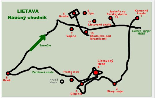
V Lietave je možné absolvovat miestny turistický náucný chodník, casový odhad cca 3h, vid schematický obrázok.
Pre hladacov :
Suradnice vas zavedu na 1 stage - jaskyna vo Farskej doline. Zoberte si zo sebou meter, aby ste vedeli na základe otázok urcit polohu finálu. Finál sa nachádza nedaleko studnicky s pitnou vodou, môžete sa tu osviežit a nacerpat silu, ak by ste sa náhodou po odlovení finálu chceli vybrat na výhliadku na Majerské skalie :-) . Na výhliadku, sa dostanete okolo referencných bodov 1. a 2. Pozor na pošmyknutie, hlavne v zime, za dažda a v noci. Z výhliadky je vidiet celá miestna cast Lietavy - Majer, ako aj Lietavský hrad a vrch Cibulník. Vlavo, tam kde je vysielac je vidiet vrch Drienovica.
Poznámka: Všetko je relativné : Z výhliadky sa domy zdajú ako "mini-keška" a váš strach pri pohlade na kraji skália môže byt a zrejme aj je ako "štandard-keška", obcas aj "maxi-keška". Ale to platí len pre tých ktorí sa tam pôjdu pozriet..
Odporúcame pozriet aj kešku Kamenné kreslá (GC1BJRP), prípadne Lietavský hrad - hladká skala(GCXVBV).
Finál : N49° 10.0(B/(C-2)+10)' E18° 40.(10*A/(C-4)-5)'
A=dlžka jaskyne pri strope - v centimetroch (zaokrúhlite na celé metre), Urcite to nie je 700
B=výška jaskyne v strede jaskyne - v centimetroch (zaokrúlite na 0,5 metra)
C=císlo zastávky, miestneho náucného chodníka - nájdete ho pred jaskynou
Specialna poznamka :
Ak uvidite v tejto skrysi zalogovany TB2HTFQ (Tedy), urcite ho nehladajte vo finálke, ani v jaskyni a zrejme nebude ani pri studnicke. Je to iba jeho domovská oblubena skrysa, kde je zalogovany ak sa nachadza nedaleko, vo svojom sidle u nas doma :-)

Cache: Majer - cave&little well&view point
Coordinates will take you to a small cave in "Farska" valley, which is found close to "Majer, local part of village Lietava.
Pottery things found in the cave in Farska valley, proves dwelling in the iron age 700 years BC up to begining AD. This area was dwelled by the tripes of Kvads up to the end of first millenium AD. Later Slavonic tripes started building hill forts called "hradiska".
Visitors of Lietava are invited to walk along local turists nature trail. It takes about 3 hours, see sketch picture.
For searchers :
Coordinates takes you to the first stage - cave in the valley. You have to take measuring tape with you to be able to answer questions for finding of final stage. The final place is situated close little well with drinkable watter. You can refresh there and take energy, if you decided to continue to view point "Majerske skalie" :-). You will catch the view point if you use referent points 1. and 2. Be careful of slipping, especially in winter, in rain and at night. From the view point you can see the whole local part of village Lietava - "Majer", as well as Lietava castle and Cibulnik hill. On the left side close the transmitter pole, you can see Drienovica hill.
Remark: Everything is relative : the houses from the view points look like "mimi cache" and your fear while looking at the rim of rocks may be and certainly is as "standard cache" event like "maxi cache". But this holds only for those, who will go to see..
We recommend to see the cache "Kamenné kreslá" (GC1BJRP), eventually "Lietavský hrad - hladká skala"(GCXVBV).
Final stage : N49° 10.0(B/(C-2)+10)' E18° 40.(10*A/(C-4)-5)'
A=the cave lenght, measured at ceiling - in centimeters (round to whole metres). It is certainly not 700.
B=cave heigth in the centre - in centimetres (round to 0,5 metre)
C=the number of stage local nature trail - you can find it in front of the cave.
Special notice :
If you see logged TB2HTFQ (Tedy) to this cache, certainly dont look for it at the final stage, nor in the cave, and certainly it will not be close the little well. It is only its home favorit cache, where it is logged, if it is found nearby in its place at our home :-)
Overovac fiiinalneho miesta / You can check your answers for this puzzle on GeoChecker.com.