Skip to content

Buckeye Traditional Geocache

Hidden : 3/30/2009
Difficulty:
2 out of 5
Terrain:
1.5 out of 5

Size: Size:   micro (micro)

Join now to view geocache location details. It's free!

Watch

How Geocaching Works

Please note Use of geocaching.com services is subject to the terms and conditions in our disclaimer.

Geocache Description:


Of course bucknuts should have the first cache placed in a town called BUCKEYE. Did you know that this BUCKEYE town is the End of the Line on 359.

Designated: September 28, 1938 Decommissioned: July 1, 2003
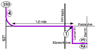
Original western terminus: US 20, later unsigned IA 941, in Alden
Original eastern terminus: Buckeye
Paving history: Unpaved at designation, the road was paved in 1960.
Replaced by: County Roads S27 (north-south segment) and D38 (southernmost mile into Buckeye)

359 Map

End of 359 Closeup

Buckeye End of Line on 359

END of Line 359

Additional Hints (Decrypt)

Vfnvnu 7:11

Decryption Key

A|B|C|D|E|F|G|H|I|J|K|L|M
-------------------------
N|O|P|Q|R|S|T|U|V|W|X|Y|Z

(letter above equals below, and vice versa)