EN
Branicke rocks
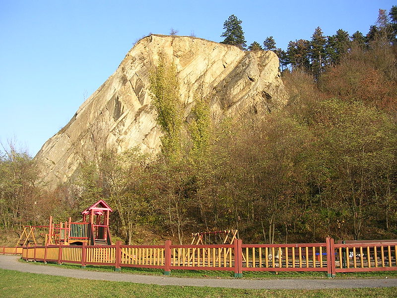
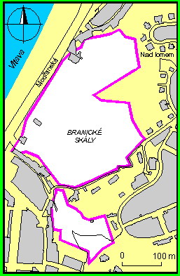
Natural monument of Branicke rocks involves prominent jag
formation on the right shore of Vltava’s river – Branicka rock and
Skolni hill are situated between Branicka and U prazskych lomu
streets. Location itself consists of two separated parts: Branicka
rock with forest park Dobeska and area of Skolni vrch. Both parts
are separated by Stara cesta street. Branicka rock fabulous of
stories about a hidden stash and ancient castle is one of the
eastest prominence of Cesky kras. It is an important view point of
Vltava’s valley. History of calcite mining is known since 18th
century. Nowadays the yield wall is the important place of outcrop
of Primary calcite (dvoreckoprokopska layers). Less remakable but
in perspective on geological viewpoint more important is nearby
Skolni hill. On the western shoulder near the peak can be found a
massive layer of calcite, full of fossil cephalopoda findings.
Probably from this place came the first fossil description from
Czech Republic area (year 1770). In 19th century the fossils were
found by Joachim Barrande an other paleontologists. North of St.
Prokop’s church is a quarry where a Primary basalt was mined
(volcanic mineral).
For logging this cache is necessary to complete some quests
(unfortunatelly answers to these questions are available only in
czech, so ask your czech geo-friends to help you, if you don’t have
any czech friends, complete the other tasks and send an e-mail, I
will assess it).
1. Answer following questions and send me
answers via Geocaching profile:
a) Branicke rocks create prominent geomorphological component in
2 Primary periods: upper ….. and lower ….. (complete)
b) Fauna: which is the generic and specific name of a reptile
that rarely lives in the rocks and of a bird that nests here?
c) Flora: name at least 2 species of protected thermopillic
flowers that grow in this area
d) Until 1918 there were branicke calcites mined in Branicke
rocks – what was the purpose of their usage?
e) Which year was this area pronouned as protected natural
area?
f) The large yield wall showed bulbed calcites from
dvoreckoprokopske layers of prag, there were found 2 kinds of
Trilobites species – that were?
2. Make a picture of you and your GPS on the
coordinates from beginning the cache listing (lower part of
Branicka rock) that way to make visible at least a part of yield
wall of the rock and upload your image to the log.
3. Find the way to the top of the rock (don’t
try to climb it – there is a good path around the eastern part
along the street Branicka and then Stara cesta) and there is
situated information table on coordinates N50 02.548 E 014 24.827
(right from wooden point of view).
After you enjoy the view, answer these questions:
a) How many ha (european unit of area) spreads the natural
monument of Branicka rock?
b) For sure that you haven’t just googled the information – send
me also how many pictures are on the information table? (map counts
as picture)

CZ
Bránické skály
Prírodní památka Branické skály zahrnuje výrazné skalní útvary
na pravém brehu Vltavy - Branická skála a Školní vrch nacházející
se mezi Branickou ulicí a ulicí U pražských lomu. Vlastní území se
skládá ze dvou samostatných cástí - z vlastní Branické skály s
lesoparkem Dobeška a z lokality Školní vrch. Obe cásti jsou od sebe
oddeleny ulicí Stará cesta. Branická skála, opredená povestmi o
skrytém pokladu a dávném hradu, je jedním z nejvýchodnejších
výbežku vápencu Ceského krasu. Tvorí výraznou krajinnou dominantu
vltavského údolí. Historie težby vápence v techto místech sahá
nejméne do poloviny 18. století. Dnes je lomová stena významným
odkryvem prvohorních vápencu (dvoreckoprokopské vrstvy). Méne
nápadný, avšak z prírodovedného hlediska ješte významnejší, je
sousední Školní vrch. Na západním úbocí nedaleko vrcholu vystupuje
mohutná vrstva vápencu, bohatých na nálezy zkamenelin hlavonožcu.
Pravdepodobne práve odtud pochází i vubec první popis zkamenelin z
našeho území z roku 1770. V 19. století tu hojne sbíral Joachim
Barrande a po nem další paleontologové. Pri ceste severne od
kostela sv. Prokopa se nachází lom, v nemž se težil prvohorní
bazalt (hornina sopecného puvodu).
K uznani logu teto kesky vas ceka nekolik ukolu:
1. Odpovedet na nasledujici otazky, odpovedi
mi poslat pres Geocaching contact
a) Branicke skaly tvori vyrazny geomorfologicky prvek ve 2
obdobich prvohor: svrchnim ...... a spodnim ...... (doplnte)
b) Fauna: jake je rodove a druhove jmeno plaza, ktery ve skalach
nehojne zije a ptaka, ktery zde hnizdi?
c) Flora: jmenujte alespon 2 druhy chranenych teplomilnych
rostlin, ktere rostou v teto oblasti
d) Az do roku 1928 s v Branickych skalach tezily tzv. branicke
vapence - k cemu slouzily?
e) V jakem roce bylo uzemi vyhlaseno chranenym prirodnim
vytvorem?
f) Vlastni rozsahla lomova stena odkryva sede hliznate branicke
vapence dvoreckoprokopskych vrstev pragu, kde byly nalezeny
zkameneliny 2 rodu Trilobitu - kterych?
2. Vyfotit sebe a svoji GPS na uvodnich
souradnicich (v dolni casti Branicke skaly), aby za vami byl videt
alespon kus lomove steny (fotku pripojte k logu)
3. Najit cestu na vrchol skaly (nezkousejte ji
vylezt, prosim, da se relativne snadno obejit vychodne ulici
Branicka a pote Stara cesta nahoru), kde se na souradnicich: N50
02.548 E 014 24.827 nachazi informacni cedule vpravo od drevene
vyhlidky.
EDIT 17.12.2009: Jelikož je puvodní
cedule ukradena, použijte prosím jinou ceduli, kterou naleznete po
ceste pri výstupu Starou cestou. Informace jsou na ní
stejné.
Az se pokochate vyhledem, odpovezte na otazky:
a) Kolik hektaru zabira prirodni pamatka Branicke skaly?
b) Aby bylo jasne, ze jste tuto informaci nevygooglili a opravdu
na miste byli, poslete nam take pocet obrazku na teto informacni
ceduli - mapka se pocita jako obrazek.

