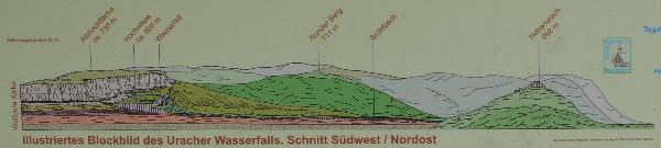
 Die Albhochfläche oberhalb des
Wasserfalls besteht aus Kalkgestein. Regenwasser versickert hier
sehr schnell und fließt unterirdisch weiter. Dabei löst es Kalk auf
und scheidet ihn an der Quelle als Kalktuff wieder aus (vgl.
schematische Darstellung).
Die Albhochfläche oberhalb des
Wasserfalls besteht aus Kalkgestein. Regenwasser versickert hier
sehr schnell und fließt unterirdisch weiter. Dabei löst es Kalk auf
und scheidet ihn an der Quelle als Kalktuff wieder aus (vgl.
schematische Darstellung).
So hat der Brühlbach im Verlauf von Jahrtausenden einen ganzen
Kalktuffklotz aufgebaut, dessen Hochfläche „Hochwiese“
genannt wird.
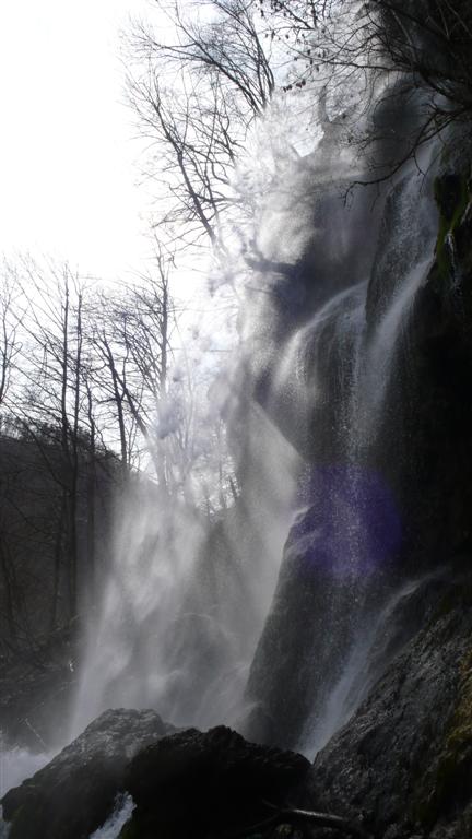
Durch eine Bachregulierung wurde der Wasserlauf so verengt, dass
sich eine Tuffschnauze bildete, die langsam über die Tuffwand
hinaus wächst. Von hier stürzt das Wasser im freien Fall 37 Meter
in die Tiefe und scheidet dabei jährlich rund 8 Tonnen Kalktuff
aus.
Die Tuffschnauze kann mehrere Meter lang werden und abbrechen.
Zuletzt geschah dies 1951.
Kalktuff war früher in der Umgebung von Bad Urach ein beliebter
Baustein. So ist z.B. die Amanduskirche aus diesem Stein errichtet.
In der ersten Hälfte des 20. Jahrhunderts befand sich darum am
Uracher Wasserfall ein Steinbruch. Man erkennt ihn noch an den
glatten Wänden, da der Tuff herausgesägt wurde.
Zum Cache: Ihr parkt entweder auf dem kostenfreien oder dem
kostenpflichtigen Parkplatz und folgt dem Wanderweg entlang des
Brühlbachs stromaufwärts zum Wasserfall.
Folgt dem Weg am Wasserfall aufwärts (ihr müsst bis ganz nach
oben). Zwischendurch macht bitte ein Foto von euch vor dem
Wasserfall an der Stelle, an der der Weg rechts vom Wasserfall weg
und steil bergauf führt (siehe Wegpunkt und Foto).
Oben angekommen müsst ihr die folgenden Fragen beantworten. Dazu
ist es notwendig, sich auf der Hochwiese ein wenig umzuschauen, um
die notwendigen Informationen zu finden.
The Alb-plateau above the waterfall is made of limestone.
Rainwater drains away very quickly and goes further underground. It
dissolves lime and deposits it at the spring as tufa again (refer
also to schematic).
Thus, the “Bruehlbach” built in the course of millennia
a whole block of tufa whose plateau is called "High Meadow".
Through a regulation of the water stream, the course of the rivulet
has been constricted that much, that it builds a nose of tufa,
growing out of the tufa wall. From here the water falls in free
fall 37 meters and deposits about 8 tons of tufa each year.
The tufa nose can grow up to several meters and can break off the
wall. Recently this happened in 1951.
Tufa was a popular material for house building arround Bad Urach.
For example the Amandus Church is built whis this stone. In the
first half of the 20th Century a quarry was located at the Uracher
waterfall. You can still see the plain walls, caused by sawing the
tufa off the wall.
The Cache: Park your car either at the parking
area with or the area without parking fee. Follow the trail along
the rivulet “Bruehlbach” upstream to the
waterfall.
Follow the track up the waterfall (you need to walk up to the top
of the waterfall). Please take a picture of you with the waterfall
in the background during your walk up the waterfall (see waypoint
and picture).
When you reach the top, please answer the following questions. To
do so, it is necessary to walk around on the plateau to gather the
required information.
Um den Cache loggen zu können müssen die folgenden Fragen
beantwortet werden:
- Wie lang in Metern ist die Kalktuffnase etwa (nur die
Nase, Wert gerundet auf ganze Meter - nur die Ziffer)?
- Aus welchem Erdzeitalter stammt die wasserundurchlässige
Schicht der Albhochfläche?
- Welches Bauwerk wurde aus den Kalktuffsteinen noch errichtet
(zwei Worte)?
Schreibe ein eMail mit deinem Geocaching-Nickname im Betreff an die
Adresse [Antwort2][Antwort1][Antwort3] @snaps-world.de (ohne
Leerzeichen, Sonderzeichen und Umlaute) und logge den Cache erst
nach Erhalt der Logfreigabe (das dauert i.d.R. nur wenige
Minuten).
To log this cache you need to answer the following
questions:
- What ist he app. length of the tufa nose in meters (only
the nose, value rounded to meters - only the number)?
- In which geological era the impervious layer of the
Alb-plateau was built?
- Which structure was also built by tufa stone? (two
words)
Write an email with your geocaching.com nickname in the subject
field to the address [answer2][answer1][answer3] @snaps-world.de
(no whitespaces, no special characters) and log the cache after you
have received the log permission (takes usually only a few
minutes).