Predem bychom chteli upozornit, ze tato kes skutecne neni drive in. Proveri vase orientacni schopnosti v terenu. Prejeme hodne zabavy a prijemny lov.
Co budete potrebovat pro odlov teto kesky!!!
* Kompas nebo buzolu
* Dalekohled
* Turistickou mapu KCT cislo 25 - Podorlicko
* Zdroj svetla o vlnove delce 200 - 400 nm
* Pevne nervy a dobre nohy
Stage 1
Na uvodnich souradnicich hledejte "pruzor" - dva zarezy cca 3mm, neco jako "musku" u strelne zbrane, kterymi kdyz se podivate, zjistite kam vyrazit na stage 2.
Stage 2
Durazne se doporucuje navstivit stage 2 v nedeli odpoledne mezi 16 a 18 hodinou za krasneho slunneho dne, v jiny cas neni stage 2 pristupna. Na druhem zastaveni budete potrebovat dalekohled a kompas. Vasim ukolem je zjistit nekolik indicii pro dalsi postup.
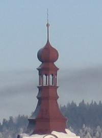
A = pocet oken na jedne strane veze kostela .....azimut 170º
B = pocet cervenych pruhu uprostred komina....azimut 255º
C = kolika horizontalnimi plošinami (ne jenom pochozimi) je rozsirena ocelova vez..... azimut 14º
D = kolik trojuhelnikovych vikyru ma nejvetsi budova (skola)...azimut 63º
E = kolik ciferniku hodin je videt na vezi kostela .....azimut 120º
F = kolik barevnych pruhu je na komine ..... azimut 200º
G = kolik barev ma fasada veze kostela....... azimut 135º
G hint zakonceni veze kostela aby nedoslo k zamene
Stage3 je vzdalena od stage2 (F-D,D*2-F,E-G,D-E-E) m a musite vyrazit pod azimutem (F-G-E,G-E,D-C) º Pro urceni pozice stage 3 doporucujeme pouzit take mapu.
Stage 3
Na tretim zastaveni budete potrebovat zdroj svetla o vlnove delce 200 - 400 nm k tomu, abyste zjistili nazev koty (stage 4). Hledejte zeleny flek, dobre ukryty pred povetrnostnimi vlivy, na kterem se po osvetlenim UV svitilnou objevi jmeno koty.
Stage 4
K tomu, abyste zjistili spravnou polohu stage 4 budete take potrebovat Turistickou mapu KCT cislo 25 podorlicko.Pozice stage 4 je oznacena v terenu vyraznym opracovanym kamenem na vrcholku kopce, ktery muzete minout a proto zde je foto hint.
Final cache
Kdyz dorazite na stage 4, kesku jiz mate na dosah ruky. Staci vyrazit pod azimutem (A,A+B+C,A-E)º do vzdalenosti (B-C,D,B-A) metru.
Pokud dorazite k cili teto kesky, jste skutecni "dravci" a zaslouzite si obdiv. Nehlede na to jakou GPS pouzivate pri geocachingu a kolik kesek mate najitych, muzete si skutecne rikat keseri.
I takoveto vyhledy se vam naskytnou behem lovu kesky panorama
This multicache will bring you to places with beautiful views and will test your orientation in terrain. It is no drive-in cache. Good luck!
For the hunt you will need:
* compass
* binoculars
* turist map KCT number 25 - Podorlicko
* a light source with wavelength 200 - 400 nm
* good condition
Stage 1
On the first stage look for two small slits. When you look through this small aim, it points towards stage 2.
Stage 2
We recommend to visit stage 2 on a sunny Sunday afternoon between 4 and 6 pm. It is not accessible at other time. Here you will need compass and binoculars.
A = number of windows on one side of the tower of the church at the azimuth 170°
B = number of red stripes in the middle of the chimney at the azimuth 255°
C = how many horizontal deckings has the steel tower at the azimuth 14º
D = how many triangular dormer-windows has the largest building (school) at the azimuth 63º
E = how many clocks can you see on the tower of the church at the azimuth 120º
F = how many coloured stripes are there on the chimney at the azimuth 200º
G = how many colours has the facade of the tower of the church at the azimuth 135º
G hint: tower of the church for G
The distance from stage 2 to stage 3 is (F-D,D*2-F,E-G,D-E-E) m and you have to head from stage 2 with azimuth (F-G-E,G-E,D-C) º. We recommend to use the map as well to find the stage 3.
Stage 3
On the stage 3 you will need a light source with wavelength 200 - 400 nm. Look for a green spot, well shielded against rain. When you use the light source, the name of the summit, where stage 4 is located, will apppear.
Stage 4
To find stage 4 you will need turistic map KCT number 25. In the landscape, the summit is marked by a hoarstone. Look at the hint photo.
Final cache
When you get to the stage 4, you are already very close. Head from stage 4 at azimuth (A,A+B+C,A-E)º to a distance of (B-C,D,B-A) meters.
If you managed to find this cache, you are a real geocacher!
Such beautiful views you can see during your hunt: panorama