The Waitakere Super Volcano, often referred to as the Manukau
Volcano, lies 20km off the coast from Piha. The now extinct volcano
is estimated to have once stood 3000-4000m tall from the sea floor.
The Manukau volcano is about the same size of Lake Taupo.
There was intermittent activity from about 22 million years ago
culminating in a violent eruption destroying itself almost entirely
some 16 million years ago, making it a much older volcanic feature
than the relatively young Auckland volcanic field. The time period
of activity from the Manukau volcano makes it a contemporary of the
Coromandel volcanoes.
Today, the razor-back ridges, rugged valleys and steep cliffs of
the Waitakere Ranges are the remnants of the eastern slopes of this
volcano, formed largely of Manukau breccia. Note that the black
sand beaches come from elsewhere: titanomagnetite swept up the
coast from Taranaki. Most of the remnants fo the volcanic island
have been eroded away by incessant marine processes and rainwater
runoff. This erosion has been interspersed with periods of uplift
which are largely responsible for the present height and tilted
"flat" top of the ranges.
This Earthcache -
Layers
This earthcache takes you to an example of distinct layering of
rock, exposed by quarrying, that belie the violent origins of the
ranges. You can park at the posted coordinates or nearby (please be
careful to park completely off the road and watch young ones around
the road as vehicles can appear suddenly).
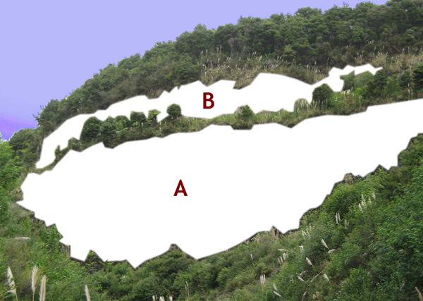
The layers you need to observe and describe constitute the cliff
face located to the south of the posted coordinates, as shown in
the figure above. You will not need to approach the cliff - rather
it is a requirement to observe from a little more distance to
answer the following question:
Question: Observe the two
distinct layers (A and B in the image) in the cliff face and
describe in your own words what the layers look like and their
origin or how they formed. You don't need to provide a phd level
essay but please describe your theory in as much detail as you can.
Email this answer to the cache owner and do not include it in your
online log.
Additional (Optional) Task:
Please also take a photo showing your GPS and looking in a
direction away from the cliff so as to not give away any spoiler
information. Upload this image with your online log.
Do not go at night as you won't see anything. Logs that
do not meet the above requirements, or are not accompanied by
emails with the correct answer, will face deletion.
You can log this cache straight away after you have
emailed your answers to the cache owner, no need to wait for
confirmation. Please include the name of this earthcache in the
email - you'd be surprised how many people forget. Also, when
contacting us with answers, if you want a reply, please include
your email address. Any problems with your answers we'll be in
touch.
Happy Earthcaching!
 KiwiGary & glyn(the
only one)
KiwiGary & glyn(the
only one)