Georgenberg near Kuchl
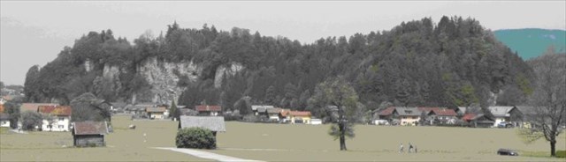
Georgenberg is a mountain located east of Kuchl. This mountain is a ridge in form of a delta, which in the vernacular is also called Dirnbergl and Dürrnbergl.
It stands about 50 meters high, is at its widest in the north side about 160 meters wide and a total of about 900 meters long. Its narrowest width in the south of the mountain is about 80 meters.
By decision of the provincial government of Salzburg from 6.12.1960 Georgenberg was declared a natural monument.
In the northern half of the mountain there are a late gothic church, some residential and farm buildings.
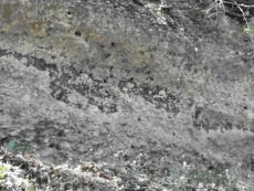
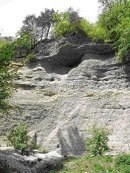
The mountain consists of interglacial conglomerate, that passes through water infiltration of calcareous gravel are consolidated. These forms are horizontal to shallow northward sloping layers, called delta gravel, which have emerged about 380.000 years ago.
 .....
.....  .....
..... 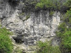
The steep cliffs of the mountain are natural formations of rocks. Such walls of solid delta gravel are also found in the other mountains in this valley, as for example Mönchsberg, Kapuzinergberg, Rainberg or Hellbrunn Mountain.
Thus arose the so-called leaching and caves by the ablation process of postglacial drainage waters of the Salzach Valley. Through the main direction of movement of the water, leaching have a southern-northern lengthwise.
The first permanent settlements on Georgenberg were already in the early Stone Age, also at the end of the 3rd Millennium before Christ, and went through all time periods.
Please answer the following questions:
1. What are the ice ages in Central Europe named. Mention 2 examples.
2. How is the conglomerate interglacial of the Alpine foothills yet known.
3. In what year was the church first mentioned.
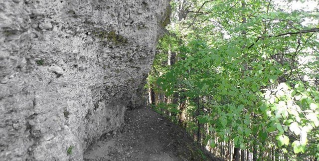
4. Guess the hight of the free visible conglomerate walls at the photo coordinates.
You must email me your answers to the questions in order to receive credit for this cache. A photo of you in front of the interglacial wall, at N 47°37.966 E013°09.814, holding your GPS out, is mandatory. Do not wait for my logpermission, if the answer or the picture is incorrect, I will contact you!!
Logs with no photo of the actual cacher logging the find or failure to answer questions will result in a log deletion. Logs with no photos will be deleted without notice.
Parking area: N 47°38.093 E 013°09.588
This EarthCache is intended for the entire family, but please note that the trail to the interglacial wall may be steeply sloping and impervious. Please use caution when attempting this EarthCache.
The cache can be done together with the cache Georgenberg by Bitwalker & Girl Scout (GCWXTT).
Der Georgenberg bei Kuchl
Der Georgenberg befindet sich östlich von Kuchl und ist ein deltaförmiger Höhenzug, der im Volksmund auch Dirnbergl und Dürrnbergl genannt wird.
Er ragt ca. 50 Meter in die Höhe, ist an seiner breitesten Seite im Norden ca. 160 Meter breit und insgesamt ca. 900 Meter lang. Seine schmalste Breite im Süden des Berges beträgt ca. 80 Meter.
Mit Bescheid der Salzburger Landesregierung vom 6.12.1960 wurde der Georgenberg zum Naturdenkmal erklärt.
Auf der nördlichen Hälfte des Berges befinden sich eine spätgotische Kirche, Wohn- und Wirtschaftsgebäude.
Der Berg besteht aus interglazialem Konglomerat, welches durch Infiltration von kalkhaltigem Wasser gefestigte Schotter sind. Diese Formen sind horizontale bis flach gegen Norden geneigte Schichtungen, genannt Deltaschotter, welche ca. vor 380.000 Jahren entstanden sind.
Die steilen Felswände des Berges sind natürliche Bildungen des Gesteins. Solche Steilwände der verfestigten Deltaschotter finden sich auch bei den anderen Bergen dieses Tales, wie z. Bsp. dem Mönchsberg, Kapuzinergberg, Rainberg oder dem Hellbrunner Berg. So entstanden auch die sogenannten Auswaschungen und Höhlen durch den Abtragungsvorgang der nacheiszeitlichen Abflußwässer des Salzachtales. Durch die Hauptbewegungsrichtung der Gewässer haben diese Auswaschungen eine südlich-nördliche Längsrichtung.
Erste Besiedelungen am Georgenberg fanden bereits in der jüngeren Steinzeit, also Ende des 3. Jahrtausends vor Christus statt und zogen sich durch alle Zeitepochen.
Bitte beantworte folgende Fragen:
1. Wonach werden in Mitteleuropa die Eiszeiten benannt, nenne 2 Beispiele.
2. Wie wird das interglaziale Konglomerat des Alpenvorlandes noch genannt.
3. In welchem Jahr wurde die Georgskirche erstmals urkundlich erwähnt.
4. Schätze, wie hoch die frei sichtbaren Konglomeratswände bei den Fotokoordinaten in die Höhe ragen.
Um diesen Cache loggen zu dürfen, maile mir die Antworten. Bitte mach ein Foto von dir und deinem GPS bei der interglazialen Wand bei den Koordinaten: N 47°37.966´ E 013° 09.814´, welches du deinem Log beifügst. Du brauchst meine Logerlaubnis nicht abzuwarten. Wenn die Antworten oder das Bild falsch sind, melde ich mich bei dir!!
Logs ohne ein Foto von dir und ohne Beantwortung der Fragen werden kommentarlos gelöscht.
Parken kannst du bei: N 47°38.093 E013°09.588
Obwohl es sich um einen Familiencache handelt, ist Trittsicherheit und Vorsicht geboten, da es sich teilweise um sehr steil abfallende Wände und Wege handelt.
Der Cache läßt sich sehr gut mit dem Cache Georgenberg by Bitwalker & Girlscout (GCWXTT) verbinden.
Happy caching
GRAC