Along the trail you will encounter a feature responsible for shaping much of the terrain in the Arctic, a unique form of ground ice often called an ice wedge. Parking for this cache is located at N 64° 51.477 W 147° 44.171 and the trailhead is found at N 64° 51.963 W 147° 44.254.
Throughout the Arctic, ground ice is one of the most important attributes of the terrain. Its presence influences topography, geomorphic processes, vegetation, and the response of the landscape to environmental changes, natural or otherwise. Ground ice may form more or less simultaneously with the enclosing sediments, as syngenetic ice; or it may form later, as epigenetic ice. In areas of seasonal frost, ice occurs primarily as lenses that cause frost heaving of the ground surface.
Foliated ground ice (or wedge ice) consists of vein ice, and typically forms vertical wedge-shaped dykes penetrating down into the permafrost and plays a very active role in forming the landscape. The wedges can vary from less than 10 cm to more than 3 m in width at the top, commonly tapering to at depths between 1 m and 10 m or even up to 25 m deep. Winter cracking of the frozen ground results in a polygonal network of vertical cracks.
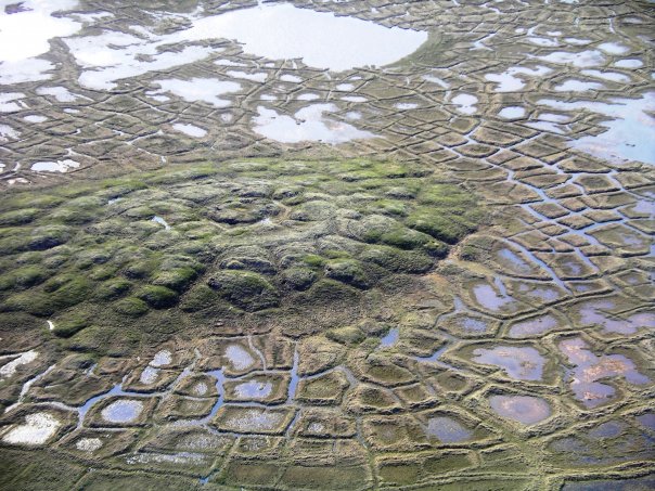
Meltwater percolates into the cracks during spring and then refreezes. Ice wedges thereby grow as each successive phase of contraction cracking is accompanied by filling of the open crack with more ice. As the permafrost warms and expands during the summer months, it is unable to return to its former position because it has been displaced by the ice wedge. Instead, the expanding permafrost pushes upward and outward, causing the ground to rise and buckle around the ice wedge. Radiocarbon dating of organic remains in ice wedges, pollen analyses, and the isotopic composition of the ice, provides evidence for the Pleistocene age of these deposits.
In addition to visiting the ice wedge site on the trail, you may need to reference the following web page at the Arctic National Wildlife Refuge site.
There is no container or log book for this cache. To claim credit for the cache you must respond via e-mail to answer the questions listed and post the required photo with your log.
To receive credit for this cache, complete the following:
1. Send an e-mail answering the following questions:
a. What is “permafrost”?
b. In what year did the terrain along the trail begin to exhibit significant change?
c. What is the above ground evidence of this change?
d. What is a “polygon”?
e. What is a “pingo”?
2. Post an original photograph of the effects of the melting wedge ice as observed from the sign on the day of your visit. This will provide a photographic record of the changes over time.
References:
"Ice wedges, polygons and pingos". Arctic National Wildlife Refuge. U.S. Fish & Wildlife Service - Alaska. 2006-02-14. http://arctic.fws.gov/permcycl.htm. Retrieved on 2009-04-19.