Take Highway 101 to Duckabush Road, where a sign
will point you to the Duckabush Recreation Area. Follow this road
for 6.2 miles to FS Rd. #2530, turn right and drive 1.3 miles.
There is a small parking area at the trailhead. A Northwest Forest
Pass is not required here. This is a short, well maintained trail
with a moderate grade. DO NOT LEAVE THE TRAIL. There is a steep
drop-off, so use caution and keep a close eye on children and pets.
Please dress appropriately, and practice "Leave No Trace"
techniques during your visit, and of course, don't forget to "Cache
In, Trash Out".
Washington State has some of the most eclectic
geology in the nation. From the rolling farmlands of Eastern
Washington to the ice-capped monolith of Mount Rainier, the cliffs
of the Columbia River Gorge to the Rain Forests of the Olympic
Mountains, you could say this state has a little bit of everything.
Thanks to it's varied terrain and ever-changing weather, the state
possesses perhaps the highest density of waterfalls in the nation.
Some of the best waterfalls on the entire planet can be found in
Washington State.
The Olympic Mountains were born in the sea. The
basalts and sedimentary rocks that form the mass of these peaks
were laid down 18 to 57 million years ago offshore, then uplifted,
bent, folded and eroded into the rugged peaks you see today. As the
land rose and the growing mountains intercepted more moisture,
trickles grew to streams, and streams grew into rivers.
Eleven major rivers radiate from the Olympic
Mountains like the spokes of a wheel. This circular spread and
radial river plan show that the Olympics developed as a separate
uplift, not as a part of a long, coastal mountain chain. These
major rivers -- including the Skokomish, Hamma Hamma, Duckabush,
Dosewallips and Dungeness, carry a tremendous volume of water
because the high Olympics, intercepting Pacific storms, receive
more rain and snow than any other place in the conterminous
states.
Waterfalls, the interruptions in the flow of a
stream or river, are abundant in the Olympic Mountains. They are
created from the difference in rock types, the structure of the
land, tectonic movement, glaciers, and lots of water. They are the
river's way of correcting irregularities by erosion and deposition.
Classification of waterfalls are based on how the water passes
through its course, how much water is flowing and by it's principle
shape. This chart shows the different forms, or classifications of
waterfalls. Many waterfalls are a combination of more than one
form.
Basic Waterfall Classifications

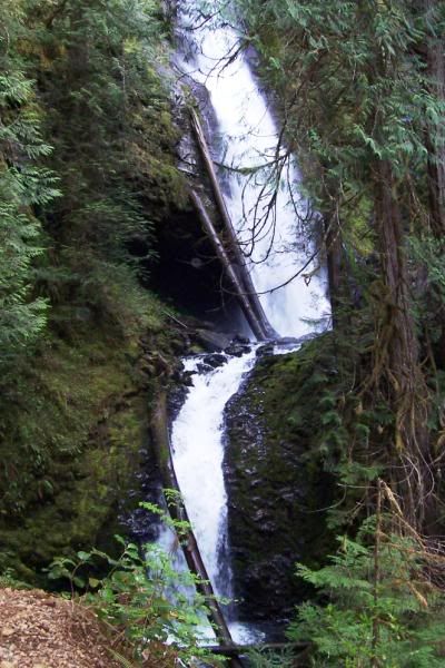
To log this cache, please message us with the
answers to the following questions (DO NOT post them
to the cache page):
1) Using the guide above, what classification (or classifications)
do you believe Murhut Falls to be and why?
2) Approximately how tall is the tallest drop of the falls?
3) What is your elevation while standing at the viewpoint? The
temperature? The weather?
After emailing your answers, please log your find and post a
photo of you or your team, with your GPS and the falls clearly
visible. Logs without ALL requirements completed will regretfully
be deleted -- so please be sure to follow the instructions
carefully!
THANKS FOR FINDING OUR EARTHCACHE!