|
   |
|
|
| Map |
 |
| Budapest |
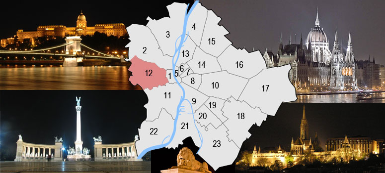
Budapest is a city of multiple characters, different geographical areas and of wide variety of architectural styles. The current city was established on 17th November, 1873 by the unification of the settlements of Pest, Buda and Óbuda on the banks of the Danube river. Budapest had 10 districts after coming into existence in 1873, numbered 1 to 10. In the 1930s, 4 new districts were organized, numbered 11 to 14. On 1st January, 1950, Budapest was united with 7 neighbouring towns and 16 villages, hence the number of its districts increased to 22. In 1994, one of the former villages left district 20 in order to form the 23rd district. Budapest's current 23 districts extend to an area of 525 square kilometres (202.7 sq mi). Most of the districts have a special flavour - from a posh downtown area one can get easily into the hilly districts of Buda or to the green suburbs of Pest. Several districts still bear the marks of the enforced industrialization of the 50s and 60s. City parks, forests of the Buda Hills, boat-houses along the Danube, flowery islands, shipyards and chemical plants, the Royal Castle and prefab housing estates are all part of this wonderful city.
The Great Budapest Geocaching Adventure guides you through all 23 districts with the goal of displaying the most typical or most unique sites in each of them. In each cache there is a code you need to uncover for the real coordinates of the bonus cache. You can find the codes on the inside of the lids of each cache container and in the logbooks. Happy caching. |
| 12th district |
| The 12th district came to existence in 1930, from a part of the 1st district. The most significant part of it is the Buda-Hill: the Janos-Hill, the Svab-Hill, Szechenyi-Hill, The Csillebérc and the Budakeszi forest. The hills are the source of fresh air and a gigantic recreation park with various walk- and trip availabilities. Here is Budapest's highest point, the Janos-hill, 528,16 m. A spot frequented by denizens of Budapest in the Buda hills, Normafa is known for its panoramic scenery and fresh air. It is located on Svábhegy and is in close proximity to Jánoshegy, the highest point in Budapest.The name is derived from the name of at tree, the "Norma tree." Traditionally the beech tree was planted by King Matthias Corvinus in the 15th century. The name stuck when performers from the Hungarian National Theater visited it, where they performed Vincenzo Bellini's Norma.. We can reach the Széchenyi-hill with the cog-rail (Fogaskereku) from the Városmajor. After the 2. World War here started up the service of the Széchenyi Childrenrail. Behind the hump on the way to Budakeszi we can find Csillebérc with the Children and Junior Center. There are more valleys on the south part of this hills: Németvölgy, Farkasvölgy, Irhás-árok and Farkasrét. |
 |
|
|
| The hiding place |
| The Elisabeth Tower offers an excellent panorama of Budapest and its surroundings in clear weather. Built in 1910, the observation tower stands proudly on the top of János-hegy (János Hill), the highest peak of Budapest (527 metres). The neo-Romanesque building was designed by Frigyes Schulek, who also designed the Halászbástya (Fishermen's Bastion) in the Buda Castle. The structure has a round base; it stands 23.5 metres tall with 4 round terraces. As it is illuminated most of the year, the Erzsébet observation tower can be easily spotted out from most parts of Budapest. The tower is open 8 a.m. to 8 p.m. The cache is above. If the tower is closed, then alternativ cache is beside the building (eloh eht kool - N 47° 31.093 E 018° 57.568 ). |
| Approaching |
 with bus 90 to Normafa and 2km on foot(visit link). with bus 90 to Normafa and 2km on foot(visit link).
 bicycle: (visit link) bicycle: (visit link)
 you can park free: N 47° 30.185 E 018° 57.957 and 2km on foot you can park free: N 47° 30.185 E 018° 57.957 and 2km on foot
|
| Budapest |
| Budapest ist eine Stadt bunten Charakters, unterschiedlicher geographischer Zonen und einer breiten Vielfalt an architektonischen Stilen. Die heutige Stadt wurde am 17. November 1873 durch Zusammenschluss der Städte Pest, Buda und Óbuda, die an beiden Ufern der Doanu liegen, gegründet. Budapest hatte damals 10 Bezirke, nummeriert von 1 bis 10. In den 30er-Jahren kamen 4 weitere Bezirke (11-14) hinzu. Am 1.Jänner 1950 wurde das Stadtgebiet um angrenzende 7 Städte und 16 Dörfer erweitert, die Zahl der Bezirke erhöhte sich damit auf 22. 1994 wurde eines der früheren Dörfer aus dem 20. Bezirk ausgegliedert, womit ein neuer 23. Bezirk enstand. Die derzeit 23 Bezirke haben eine Ausdehnung von insgesamt etwa 525km² (202,7mi²). Die meisten dieser Bezirke haben ihren unverwechselbaren Charakter - von repräsentativen Innenstadtbereichen über die hügeligen Bezirke von Buda bis hin zu den erholsamen grünen Vorstädten von Pest ist alles zu finden. Einige Bezirke stehen bis heute im Zeichen der stark forcierten Industrialisierung der 50er- und 60er-Jahre. Stadtparks, die Wälder der Budaer Berge, Bootshäuser entlang der Donauufer, blütengezierte Inseln, Werften und Chemiebetriebe, die königliche Burg und auch Fertigteil Wohnhausanlagen sind alle Teil dieser wundervollen Stadt. Das Große Budapester Geocaching Abenteuer wird durch jeden der 23 Bezirke führen und versuchen, in jedem etwas Typisches oder Einzigartiges zu zeigen. Jedem, der alle 23 Caches besucht, winkt als Draufgabe ein BONUS-Cache. Happy Caching. |
| 12. Bezirk |
| Als Hegyvidék wird der 12. Bezirk in Budapest bezeichnet. Der Bezirk liegt in der Mitte Budas in einem bergigen Gelände. Ein großer Teil der Fläche ist Waldgebiet. Im Norden des Hegyvidék befindet sich der 2. Bezirk, im Osten der 1. Bezirk und im Süden grenzt er an den 11. Bezirk. Die westliche Grenze ist gleichzeitig auch die Stadtgrenze von Budapest. Nachbarorte sind Budakeszi und Budaörs. Mit rund 60.000 Einwohnern liegt der Hegyvidék im Vergleich zu anderen 23 Bezirken an 18. Stelle. Der 12. Bezirk ist in folgende Stadtteile untergliedert: Budakeszierdo (teilweise), Csillebérc, Farkasrét, Farkasvölgy, Istenhegy, Jánoshegy, Kissvábhegy, Krisztinaváros (teilweise), Kútvölgy, Magasút, Mártonhegy, Németvölgy, Orbánhegy, Sashegy (teilweise), Svábhegy, Széchenyihegy, Virányos und Zugliget. weitere info: |
|
| Das Versteck |
| Der Elisabeth Turm bietet ein ausgezeichnetes Panorama Budapests und seine Umgebungen im klaren Wetter an. Gebaut 1910 steht der Beobachtungsturm stolz auf der Spitze des János Bergs (János Hügel), die höchste Spitze Budapests (527 Meter). Das neo romanische Gebäude wurde durch Frigyes Schulek entworfen, wer auch den Halászbástya (die Bastion von Fischern) im Buda Schloss entwarf. Die Struktur verdaut die runde Basis; es steht 23.5 Meter hoch mit 4 Runde-Terrassen. Weil es sich jetzt des Jahres erhellte, kann der Erzsébet Beobachtungsturm in leicht entdeckt aus jetzt Teilen Budapests. Die Turm ist offnenen 8-20 Uhr. Die cache ist oben. Wenn die Turm ist geschlossen, dann alternative cache ist neben Gebäude. (hcoL sad ni - N 47° 31.093 E 018° 57.568) |
| Verkehrsverbindung |
mit dem Bus 90 bis Normafa, dann 2km weiter zu Fuss(visit link).
Radweg: (visit link)
Du kannst parken kostenlos hier: N 47° 30.185 E 018° 57.957 dann 2km weiter zu Fuss
|
| Budapest |
| Budapest ezerarcú város, melyet földrajzi változatossága és építészeti sokszínusége varázsol egyedivé. Az 1873. november 17-én Pest Buda és Óbuda egyesítésével létrejött akkori fovárosnak 10 kerülete volt, amely az elkövetkezo évtizedek során fokozatosan bovült a mai 23-ra. A város ma 525 négyzetkilométeren terül el. A különbözo kerületek a folyamatos fejlodés és átalakulás mellett továbborzik sajátosságaikat, a Belváros csillogó bevásárló utcái, Buda dombvidéke vagy a pesti zöldövezet lakónegyedei mind sajátos hangulattal bírnak. A város arcát továbbra is sebhelyként csúfítják az 50-es 60-as évek eroltetett iparosításának "emlékmuvei". Zöld parkok és ligetek, a Budai hegyvidék erdoi, Duna-parti csónakházak, virágos szigetek, hajógyárak és vegyi üzemek, a Budavári palota és panel lakótelepek - ez mind Budapest. A Nagy Budapesti Geocaching Kaland végigvezet mind a 23 kerületen bemutatva az adott városrész legjellegzetesebb vagy éppen a legfurcsább vonását Ha mind a 23 ládát megtalálod, indulhatsz a BONUS csésze megkeresésére. Kalandra fel! |
| 12. kerület |
| Budapest XII. kerülete (a Hegyvidék) a város budai oldalának középso, foképp hegyvidéki területein fekszik. Jelentos területeit erdo borítja. Északon a II. kerület, keleten az I. kerület, délen a XI. kerület határolja. Nyugati határa egyben Budapest határa is, a szomszédos települések Budakeszi és Budaörs. A XII. kerület 1930-ban jött létre Budapest közigazgatásának átszervezése kapcsán az I. kerület egy részébol. A kerület története lényegében a Buda vonzáskörében, annak közigazgatási területén élo kisebb települések, majorságok, erdo- és szolobirtokosságok történetébol tevodik össze. bovebb info: |
|
| A rejtek |
| Az Erzsébet-kilátó mintegy száz éve közismert kirándulóhely, mely Budapest legmagasabb pontján, a Budai-hegységbetartozó kupola formájú János-hegy tetején, 527 méteres tengerszint feletti magasságon áll. A kilátótorony építése elott a hegyteton egy alacsony, fából készült emelvény állt, amit 1908-ban bontottak le. A kobol készített kilátótorony építését Glück Frigyes[1] javasolta, majd gyujtés indult az építkezéshez szükséges pénz eloteremtésére, aminek során 51 000 korona gyult össze. A fováros közgyulése 1907-ben elfogadta az építkezés tervét, és Schulek Frigyest bízták meg a tényleges tervek elkészítésével. 1908 tavaszán indult be az építkezés. Az építés vezetoje Kluczinger Pál volt. Az építkezéshez szükséges köveket a hegy elott elterülo lapos tetorol épített kötélpályával szállították a helyszínre, míg a vizet puttonyos kocsikon szállították fel a Svábhegyrol. Az építkezéshez haraszti és borosjenoi mészkövet használtak fel. A felépült kilátótornyot 1910. szeptember 8-án adták át a közönségnek, és Erzsébet királynéról nevezték el, aki 1882-ben járt a hegyen. Ez az építmény az akkori Európa egyik leghatalmasabb ilyen jellegu építménye volt. Neoromán stílusban épült, kör alaprajzú építmény 23,5 m magas és 100 lépcso vezet fel a legfelso szintre. Az alapnál az épület kerülete 53 méter, majd a felére csökken. A negyedik teraszról tiszta idoben 75–80 km-es körkilátás nyílik, ritka tiszta idoben a Magas-Tátra csúcsai is kivehetok. A szocializmus éveiben a kilátó tetejét messzire világító vörös csillag díszítette, melyet azóta eltávolítottak. Az 1990-es évekre a kilátó állaga leromlott. Életveszélyes állapota miatt a elso szinteket a látogatók elol lezárták. 2001 és 2005 között teljesen felújították. A kilátó nyitva 8-20 óráig. A ládát fent keresd. |
| Megközelítés |
90-es busszal Normafáig, onnan 2 km gyalog (menetrend).
Kerékpárral: (térkép)
Autóval itt ingyen parkolhatsz: N 47° 30.185 E 018° 57.957. Innen 2 km gyalog.
|