Hohenstein EarthCache
-
Difficulty:
-

-
Terrain:
-

Size:  (other)
Please note Use of geocaching.com services is subject to the terms and conditions
in our disclaimer.
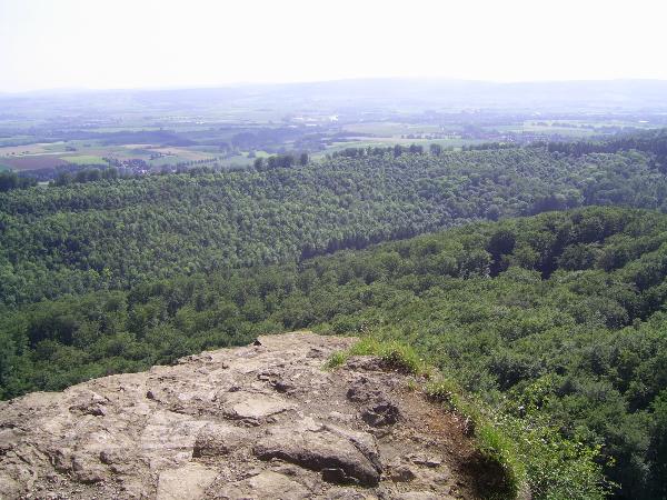
Aussichtspunkt über das Wesertal - View point over the river Weser
valley
Achtung: Naturschutzgebiert! - "Attention: nature reserve
area!

Dieser Aussichtspunkt entstand im Zeitalter der Eiszeiten. Er liegt
im Südwesten des Süntels, welcher hauptsächlich aus Jura-Kalkstein
besteht, das ein Alter von über 150 Millionen Jahren hat.
Die Aussicht über das Wesertal und zum Lippischen Bergland ist
herrlich. Dieser Teil des Wesertals wurde durch die Eiszeiten
geformt. Zwischen den Eiszeiten lagen verschiedene klimatische
Perioden.
Mächtige Massen von glazialem Eis drangen von Skandinavien her nach
Deutschland vor. Zwischen den einzelnen Schüben der Eiszeit
herrschten aber auch Warmzeiten.
Typische Ablagerungen für die verschiedenen klimatischen Perioden
können noch heute hier gefunden werden. Ablagerungen in der Weser
etwa bezeugen, dass der Fluss einstmal ein andres Flussbett als das
heutige hatte. Von Hameln floß die Weser in Richtung Springe, durch
die Deisterpforte.
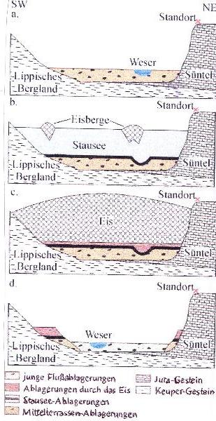
In der Elster-Eiszeit, die vor 500000 Jahren begann, wurde dem
Fluss hier der Weg durch Eis versperrt. Also musste sich die Weser
einen neuen Weg bahnen und zwar durch das Tal zwischen Süntel und
Lippischem Bergland.
Die ältesten Segmente datieren etwa 400000 Jahre zurück. Man nennt
sie "Mittelterrassen-Ablagerungen", wobei es sich hauptsächlich um
Kies handelt.
Die nächste Eiszeit fand zwischen 330000 und 127000 Jahren statt;
diesmal wurde die Weser ganz aufgestaut, sodass das Wesertal zu
einem großen See wurde. Das Eis drang aber auch in den Wesertal-See
vor und nahm diesen ganz ein. Nach dem Abschmelzen des Eises
hinterließ das Eis Ablagerungen, die man Moräne nennt. Diese
beweist, das das Eis tatsächlich bis hier vorgedrungen ist.
Seit dem Ende der Saale-Eiszeit nutzt die Weser aber dieses "neue"
Flussbett!
Mache ein Foto von dir mit dem GPS an der angegebenen Stelle!
Fragen, die uns bitte per Mail beantwortet werden:
1. Welche Stadt ist rechts oben auf der Steintafel zu sehen?
2. Wie hoch befindest du dich nach der Angabe auf der Steintafel
über dem Meeresspiegel?
3. Wie hoch ist der Höhenunterschied zwischen deinem Standpunkt und
dem Parkplatz Kreuzsteinquelle bei N52°11.447 und
E009°18.792?
Viel Spaß und viel Erfolg!
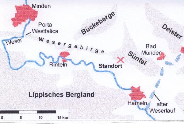

This view point was created by the ice ages. It is in the south
west of the Süntel mountain range which predominantly consists of
jurassic limestone of an age of 150 million years.
There is a wondeful panoramic view over the valley of the river
Weser and the hights of the Lippe area.
This part of the river Weser valley was formed in the ice age.
During the ice age there were enormous changes in the
climate.
Mighty masses of continental ice spread repeatedly from
Scandinavia into Germany. In between the shifts of glacial ice
there were also warm periods.
Typical segments which were created during the different phases of
climate can still be found in this area. Segments in the river
Weser show that it formerly had another riverbed. From Hameln the
river flew towards Springe, through the gate of
Deisterpforte.
This way was barred by the ice within the Elster ice age which
started approximately 500000 years ago.
So the river was forced to find another way. From this time on it
flows through the valley between the Süntel mountain range and the
hills of Lippe.
The oldest segments in this part of the valley date back 400000
years. They are called "central terrace segments" and usually
consist of gravel.
The river Weser faced another ice age, the Saale ice age, 330000 -
127000 years ago. This time the river was stowed and a lake rose in
the valley. Finally the ice entered the valley, filling it
completely.
After its melting segments remained which are called a moraine.
They prove that the ice was actually in the valley.
Since the end of the Saale ice age the river Weser has used the
"new" riverbed.
Take a photo of yourself and the GPS device at the spot,
please!
Answer the following questions:
1. Which city is on the top right at the stone that lies near the
cliffs?
2. What is the height above sea level according to that
stone?
3. You see the river Weser far below. The river has made its bed
through the hills. What is the difference in height between the
view point and the car park Kreuzsteinquelle at N52°11.447 and
E009°18.792?
Have fun and good luck!
Additional Hints
(No hints available.)