This is an "exchange cache". I supplied the ammobox container,
helped design the first page of the log book, but the real leg work
was supplied by Fish Eagle and GPS Storm who placed the cache Fish
Eagle had assembled and protected from scratches with a camo cover.
Thanks Andy and Chris. I will return the favour by placing a cache
for Fish Eagle near my home in the United States. We will also be
maintaining each others caches. The cache waypoint number
GC1TEGH of course stands for "Geocaching's First
Transatlantic Exchange Geo Hide". ;)
From the online encyclopedia, Wikipedia:
Kaapsehoop is a town in the Mpumalanga province (formerly Eastern
Transvaal) of South Africa. It is situated 1486m (4878 ft.) above
sea level on the Highveld escarpment, about 25km from Nelspruit,
the capital of Mpumalanga. The name of the town is no doubt derived
from the fact that when gold was discovered in the town, the find
created hope for the early inhabitants of the geographically nearby
De Kaap Valley - The Cape Valley - of attaining great wealth.
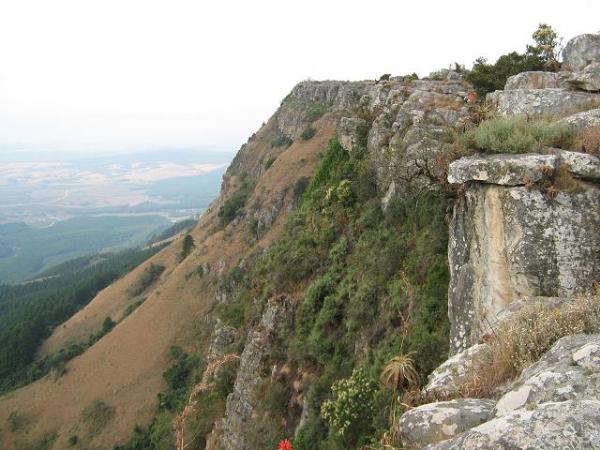
Kaapsche Hoop (as more correctly spelt in High Dutch) is set out
between large natural clearings in the rock fields near the top of
the escarpment overlooking the lush De Kaap Valley situated some
800 metres below, with distant views towards Barberton and
Nelspruit.
Kaapsehoop was originally to gain fame as a gold mining town
once known as the Duiwels Kantoor - the Devil's Office -
towards the end of the 19th century, when gold was discovered in
1882 in a small creek running through the town. This led to portion
of the original township layout being cancelled and opened up for
gold diggings. However the earlier better paying discoveries of
gold at both Pilgrim's Rest in 1873 and Barberton in 1881, followed
by the discovery of gold on the Witwatersrand in 1886 (later to
become the town of Johannesburg), coupled with the meager returns
obtained at Kaapsche Hoop led to the town going into decline.
The town has been "re-discovered" in recent time and has now
become a popular weekend geocaching retreat with its period housing
including accommodation establishments. New housing (some
unfortunately not period) has also been established on some of the
remaining vacant stands(erven). The town is also within commuting
distance of the centre of Nelspruit situated some 30 odd kilometres
away.
There are two routes to the cache:
Route A (highly recommended) - This is the shorter, more
interesting, and more exciting route. From the parking, follow your
GPS and the white trail markers past the hikers hut to the cache.
The terrain is quite rough, and there are caves and deep rock
fissures. If you have children with you, keep them under tight
control after you pass the hikers hut. Some of the fissures are not
obvious, and they're very deep.
Route B - This route is a bit longer, but has easier gradients
and safer terrain. From the parking, head south for the waypoint
"Trail Intersection", and follow the marked trails to the
cache.
Be sure to view the beautiful photos below taken by Chris and
Andy.