Posted coordinates are on the new asphalt pathway near the west end of the Klippert gravel quarry. NOTE: the City of Calgary is undertaking an extensive effort to reclaim many of the unofficial trails in the park. Please stay on official trails while in the park. You can park at the lot at the corner of Home Road and 32 Avenue NW or, for a slightly longer walk, in the parking area at the south end of Silver Springs Blvd NW.
During the Quaternary Period Ice Age (from about 2 million to 11 thousand years ago), two different glacier flows moved into the Calgary area. The Cordilleran glaciers flowed eastward from the Rocky Mountains and met the Laurentide Ice Sheet flowing into the area from the northeast. As the Cordilleran glaciers melted, the run-off water was blocked by the Laurentide Ice Sheet resulting in the formation of Glacial Lake Calgary. Glacial silt settled at the lake bottom, up to 60 metres thick in some parts of Calgary.

At the end of the ice age, Glacial Lake Calgary drained away. As it drained, the Bow River cut through the lake sediments and glacial tills below the silts, exposing the bluffs you can see from the posted coordinates, just behind (north) of the Klippert gravel quarry. Look for two different layers of materials in the bluffs: there is a dark layer of soil at the very top and just below that, a thick layer of fine lake silt which forms the upper part of the bluffs. This layer of silt is one of the finest exposures of Glacial Lake Calgary sediments. You will also notice some glacial till that lies below the silt bluffs. The accompanying photo taken in another area of northwest Calgary should help you identify the silt bluff and glacial till features.
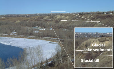
Photo: B. Groulx, http://geoscape.nrcan.gc.ca/calgary/topics/slope_e.php
Because the glacial silt is unstable, bluffs in Calgary are frequently eroded by mudflows and rotational slumps. Factors that make a mudflow more likely include steep slopes with little vegetation, an easily erodible source material and heavy precipitation (snowmelt or rain). Mudslides can reach speeds of up to 100 kph (60 mph).
Rotational slumps are a type of landslide which happens when a more or less a block of material slides on a curved failure surface, causing the upper surface to tilt back. Slumps can be induced by seismology, wave action undercutting lower layers of coastal cliffs, or (most likely in Calgary) precipitation lubricating a clay layer so that the overlying block of materials slides along the clay layer.
A few years ago, there were concurrent mudflow and slump events along the bluffs in Wildwood. This location is the study site for GC1Q2YR Wildwood Landslide, an earthcache by bish0p.
Fortunately, as at the date this earthcache was set up, the bluffs in Bowmont Park haven’t (yet) been significantly affected by mudflow and slumping events. Looking NE from the posted coordinates, you will see sections of basically undisturbed glacial lake sediments and glacial till (these look quite rounded and are the exposures that have naturally weathered and eroded after the Bow River carved its way through the upper elevations of the bluffs). Looking directly East from the posted coordinates, you will see a disrupted section of the bluffs (at the time this earthcache was created, plastic orange fencing was installed at the top of this section to prevent anyone from closely approaching the abrupt drop off).
To minimize the occurrence of landslides in Calgary, the city has implemented land-use and engineering guidelines. Since 1978, an evaluation of slope stability by a qualified engineer must precede development at any site where final design slopes exceed 15% (about 9°).
Objective: Use your imagination to picture Glacial Lake Calgary, the erosion of the lake bottom by the Bow River and the effects of weathering, erosion, slumping and sliding on the resulting bluffs that run parallel to the north bank of the Bow River.
Educational Requirement: To get credit for this earthcache you must e-mail a short note to the cache owner which contains all the following information:
- The text GC1TEHC Silt, Slump, Slide on the first line.
- The number of people in your group.
- Look directly East at the more disrupted section of the bluffs, behind the fenced off quarry. Has this section been disrupted by slumping or sliding? Include your reasoning.
Photos of you or your GPS with the silt bluffs in the background would be much appreciated.
Sorry Folks, no photo and your log will be deleted.
SOURCES: Calgary’s Natural Parks – Yours to Explore by Jim Foley published by Calgary Field Naturalists’ Society, 2006; Geological Survey of Canada website; Geoscape Calgary website.