Rideau
Falls
The Rideau Falls is
a waterfall located in Ottawa, Ontario where the Rideau River
empties into the Ottawa River. The falls were named by Samuel de
Champlain in 1613. Champlain felt that the wall of water resembled
a curtain, or rideau in French. The Rideau River was later named
after the falls. The Rideau Falls can best be admired from the
other side of the Ottawa River in Gatineau, Quebec. On the other
hand, very few have had the opportunity to walk on a pedestrian
bridge perched right on top of the water plunging into another
river below.
Geological
Formation

The Ottawa valley is
a lowland traversed by the Ottawa River and its tributaries and
bordered by the rugged terrain of the Canadian Shield. Over
geological time, this area has experienced mountain building and
erosion, tropical and temperate seas, thick ice sheets, and erosion
by rivers. The greater Ottawa-Gatineau area is underlain by soil,
sediment, and rock that have been, and still are being, shaped by
earth processes, yielding a geological landscape. The resistant
Precambrian granitic and metamorphic rocks of the Canadian Shield
form highland areas that are characterized by rough terrain,
numerous small lakes, and abundant rock outcrops. In contrast, the
flat-lying Paleozoic rocks underlie lowland plains and low hills,
and outcrops are confined largely to low scarps and riverbanks.
Much of the region is covered by a blanket of Quaternary sediments
which form landscapes that range from gently undulating plains and
low hills of glacial deposits to the flat plains of the Champlain
Sea.
Tributary
The Rideau River is
a tributary of the Ottawa River and the Rideau Falls are at the
confluence of the Ottawa and Rideau Rivers. A tributary is a stream
or river which flows into a mainstem (or parent) river. A tributary
does not flow directly into a sea. Tributaries and the mainstem
river serve to drain the surrounding drainage basin of its surface
water and groundwater by leading the water out into an ocean or
some other large body of water.
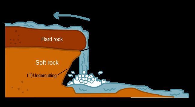
Waterfalls
A waterfall is
usually a body of water resulting from water, often in the form of
a stream, flowing over an erosion-resistant rock formation that
forms a nickpoint, or sudden break in elevation. Often, the rock
stratum just below the more resistant shelf will be of a softer
type, meaning that undercutting due to splashback will occur here
to form a shallow cave-like formation known as a rock shelter or
plunge pool under and behind the waterfall. Eventually, the
outcropping, more resistant cap rock will collapse under pressure
to add blocks of rock to the base of the waterfall. These blocks of
rock are then broken down into smaller boulders by attrition as
they collide with each other, and they also erode the base of the
waterfall by abrasion, creating a deep plunge pool or gorge.
Streams become wider and shallower just above waterfalls due to
flowing over the rock shelf, and there is usually a deep pool just
below the waterfall because of the kinetic of the water hitting the
bottom. Waterfalls normally form in a rocky area due to
erosion.
Types of
Waterfalls
Block: Water descends
from a relatively wide stream or river.
Cascade: Water
descends a series of rock steps.
Cataract: A large,
powerful waterfall.
Fan: Water spreads
horizontally as it descends while remaining in contact with
bedrock.
Horsetail: Descending
water maintains some contact with bedrock.
Plunge: Water
descends vertically, losing contact with the bedrock
surface.
Punchbowl: Water
descends in a constricted form and then spreads out in a wider
pool.
Segmented: Distinctly
separate flows of water form as it descends.
Tiered: Water drops
in a series of distinct steps or falls.
Multi-step: A series
of waterfalls one after another of roughly the same size each with
its own sunken plunge pool.
To log this
Earthcache, you must:
Take a photo of
yourself along with your GPS at the posted coordinates with the
falls taken from on top of the walkway or from either side of the
falls.
Email, through my
profile, the answers to the following questions: Do not post the
answers on the cache page.
1) Approximately how
high are the falls?
2) Approximately how
wide are the Falls?
3) Referring to the
above types, what type of falls are the Rideau Falls?
4) Describe in your
own words, how the Rideau Falls was created?
5) Identify the type
of rocks found at the confluence of the Rideau and Ottawa
rivers?
Logs without the
required picture or without the answers sent via e-mail through my
profile will be deleted.
View of the Rideau
Falls from across the Ottawa River in Gatineau, Quebec.
