There's Quartzite In Those Hills!! EarthCache
There's Quartzite In Those Hills!!
Please note Use of geocaching.com services is subject to the terms and conditions
in our disclaimer.
FTF Congratulations to Night
Hawk and BearOakDruid!!!
There’s Quartzite In Those
Hills!!
As you approach the 2 mountain ridge
lines that are part of Hanging Rock State park, you may
be impressed by how high they are. The ridges are actually
monadnocks, which are isolated mountains of resistant rock rising
above the eroded lowland. When you stand atop Hanging Rock, Moore’s
Knob, or Cook’s Wall gazing out at the surrounding Piedmont
Plateau, you should be impressed, not with the height of the
mountain, but with how much the surrounding land has eroded and
shrunk away.

Moore's Knob, Sauratown Mountains
This Earth Cache, located in Hanging Rock
State Park, will provide you with an up-close look of
the erosion resistant rock that makes up the series of ridges that
run west/southwest from Hanging Rock to Pilot Mountain.
Collectively, they are the Sauratown Mountains. They all share one
characteristic. The rock forming the monadnocks is far more
resistant to erosion than is the rock that underlies and surrounds
them. The rock is quartzite.
The core rocks and base of our
area were formed over a billion years ago and then
subjected to numerous geologic events. However, the quartzite
monadnocks of the Sauratown Mountains formed during the violent
transformation of the earth’s crust in our area when the last
collision of the African and North American continents thrust the
Appalachian Mountains upward about 300 million years ago. These
monadnocks are not part of the Appalachian chain, but the same
event that created them helped create these monadnocks. The
collision was a huge geological event that compressed, folded,
fractured, thrusted and even melted various portions of the crustal
rocks over time of what is now North Carolina. The event along with
the other prior great crustal events provided an array of rocks
beneath the piedmont area North Carolina. Then about 200 million
years ago, the continents reversed the intense pressure and began
moving away from each other. This provided even more diverse
features in the earth’s crust under our area. As the continents
moved away, forming the Atlantic Ocean basin, it created a
tensional stretching that created many cracks and fractures that
were filled from below with many more types of molten materials. So
we have many different types and layers of hard, erosion resistant
rocks and weaker crustal layers in the North Carolina area. The
stage was set for the erosion to begin formation of today’s
monadnocks we see.
The compression that led to the
overthrusting, and the overthrusting itself combined to generate
enough heat to alter old beach sands that were shoved inland as the
continents collided. The sand subsequently crystallized into
today’s quartzite. The huge forces involved caused the quartzite to
fold back on itself like a fold in a rug to create the high crest
of horizontal beds that characterize the ridges of the Sauratown
Mountains.
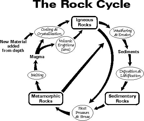
Quartzite is a metamorphic rock.
Metamorphic rocks are formed when heat and pressure change existing
rock without actually melting it. It has recrystallized in a solid
state as a result of the changes in temperature, pressure, and
chemical environment. Quartzite is composed of firmly cemented
quartz grains, or from metamorphized quartz sandstone. The “parent”
rock of quartzite is sandstone, a sedimentary rock which formed
when layers of sand were laid under the ancient seas. The weight of
the water and sediments above squeezed the sand grains close
together. The sand combined with minerals dissolved in the sea
water. The minerals crystallized around the sand grains and glued
them together like cement. Most often quartzite is white, light
gray, yellowish, or light brown, but is sometimes colored blue,
green, purple, or black by included minerals. The cap rocks you see
all along the Sauratown Mountains are quartzite.
It has resisted erosion and
weathering as the surrounding rocks and soils have been
washed away and carried downstream by the many creeks and rivers of
our area. An interesting feature of quartzite is not only HOW
extremely slowly it erodes, but the WAY it erodes. It forms curved
surfaces that geologists call “spherical or curved weathering.”
There are many exposed quartzite areas along the Sauratown
Mountains where you can witness this first hand. I’ve picked an
especially pretty area to view the quartzite, so pack a picnic and
enjoy the hike!
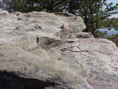
Spherical or Curved Weathering
The Earth Cache’s posted coordinates will
take you to the Window Falls overlook along the Indian Creek Trail.
If you are facing the falls, there will be a wall of quartzite to
the right and behind. You will need to inspect these rocks to
answer the questions below.
Please keep safety in mind
and observe ALL park rules.
Thank you for your interest in this Earth Cache and I
hope you enjoy it!


Developed by a Platinum EarthCache
Master
>To receive credit for this Earth
Cache:
Post a picture of you, with your GPSr, standing on the overlook in
front of the railing and waterfall in your on-line log.
AND email the answers to me for the following questions. Any logs
with answers will be deleted.
1. What color is the quartzite in this location?
2. What evidence of compression do you see?
3. Look for signs of erosion to the quartzite wall. What do you
see?
4. Is there evidence of spherical weathering?
5. Has the quartzite rock located in the waterfall’s path eroded
any differently? If so, how and why do you think it has?
6. How do you think the ‘window’ in the wall formed?
7. Estimate the height of the quartzite wall.
8. How many man-made stone columns are there around the viewing
area?
The picture MUST be uploaded immediately after
posting your log AND the answers to the questions MUST be sent
within a reasonable amount of time on the same day as you claim
your smiley. All logs not complying will be deleted without notice.
As of 7-30-09, I will no longer send out reminder emails asking for
the information.
Additional Hints
(Decrypt)
[This portion of Indian Creek Trail to Window Falls is 0.6 miles one way and is rated moderate by Hanging Rock State Park Trail Map.]
Treasures
You'll collect a digital Treasure from one of these collections when you find and log this geocache:

Loading Treasures