Gollinger Wasserfall
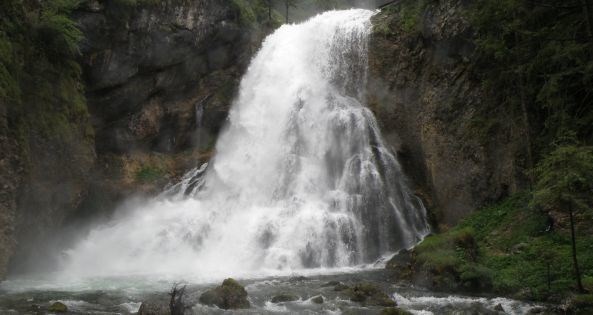
It is one of the most famous natural monuments in Austria, which is located in Torren, a borough of Golling, on the north flank of a gigantic mountain massive, whose highest peak is called Hoher Göll.
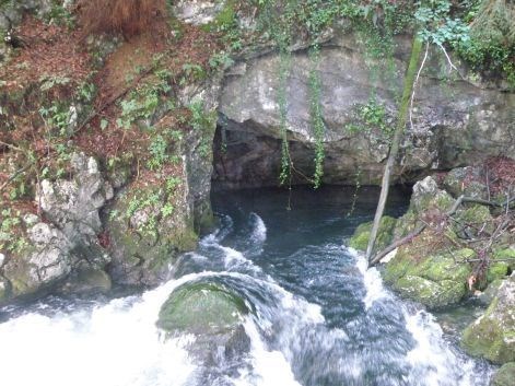
This waterfall, which is also called Schwarzbachfall, rises 580 meters above sea level out of a cave and crashes into two cascades in powerful form of 76 meters in depth.
The flow of water is approximately 15.000 to 20.000 l/s. In winter, however, there are often only 30 to 40 l/s waterflow from different smaller caverns.
The roots of water come from the higher located Kingslake in Bavaria (Germany). On the east side of the lake, located near the King´s Creek, there is the so called Kuchler- or Gollingerloch, through which the water finds its subterranean way to the waterfall.
 .............
  .............
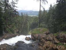
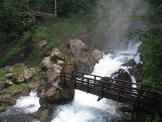
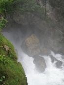
If you stand in front of the first cascade of the waterfall, you are faced with a huge cliff of coarse-grained conglomerate. In the Ice Age the debris were squeezed through the glacier activity on this rock. At the foot of the second cascade is a huge natural bridge, which is partially misplaced by giant boulders. The whole Göllmassive consists mainly of superficial Dachstein-Lime, the deeper layers consist of Dachstein-Dolomite and Wetterstein-Dolomite.
Please answer the following questions:
1. By whom was the waterfall made available to the public?
2. When was the metal bridge between the cascades mounted?---Because of restauration, you don´t have to answer this question now!!
3. Guess, how high is about the waterfall of the upper cascade?
You must email me your answers to the questions in order to receive credit for this cache. A photo of you in front of the cave at the origin of the waterfall, at N 47°36.053 E013°08.172, holding your GPS out, is mandatory. ---You can also take a picture in front of the waterfall. Do not wait for my logpermission, if the answer or the picture is incorrect, I will contact you!!
Logs with no photo of the actual cacher logging the find or failure to answer questions will result in a log deletion. Logs with no photos will be deleted without notice.
Parking area: N 47°36.103 E 013°08.418
This EarthCache is intended for the entire family, but please use caution when attempting this EarthCache.
Gollinger Wasserfall
Es handelt sich hier um eines der sehenswertesten Naturdenkmäler Österreichs, welches sich im Gollinger Ortsteil Torren an der Nordflanke eines gigantischen Gebirgsstockes, dessen höchste Erhebung der Hohe Göll ist, befindet.
Dieser Wasserfall, welcher auch Schwarzbachfall genannt wird, entspringt in 580 Meter Seehöhe einer Höhle und stürzt sich in 2 Kaskaden in gewaltiger Form 76 Meter in die Tiefe.
Die Durchflussmenge des Wassers beträgt ca. 15.000 bis 20.000 l/s. Im Winter fließen jedoch oft nur ca. 30-40 l/s aus diversen Nebenhöhlen.
Seinen Ursprung hat das Wasser im höher gelegenen Königssee in Bayern. An der Ostseite des Sees befindet sich in der Nähe des Königsbaches, das Kuchler- oder Gollingerloch, durch welches das Wasser seinen Weg bis zum Wasserfall findet.
Sobald man die erste Kaskade des Wasserfalls sieht, steht man vor einer gewaltigen Felswand aus grobkörnigem Konglomerat. In der Eiszeit wurde das Geröll durch die Gletschertätigkeit zu diesem Gestein gepresst. Am Fuße der zweiten Kaskade befindet sich eine riesige Naturbrücke, welche durch gigantische Felsblöcke teilweise verlegt ist. Das ganze Göllmassiv besteht oberflächlich hauptsächlich aus Dachsteinkalk, die tieferen Schichten bildet der Dachsteindolomit und Wettersteindolomit.
Bitte beantworte folgende Fragen:
1. Durch wen wurde der Wasserfall der Öffentlichkeit zugänglich gemacht?
2. Wann wurde der Metallsteg, zwischen den Kaskaden montiert?--Diese Frage ist aufgrund von Bauarbeiten momentan nicht relevant!!
3. Wie hoch ist ca. die obere Kaskade des Wasserfalls?---Schätzung!!
Um diesen Cache loggen zu dürfen, maile mir die Antworten. Bitte mach ein Foto von dir und deinem GPS bei der Ausgangshöhle bei den Koordinaten: N 47°36.053´ E 013° 08.172´, welches du deinem Log beifügst.--Aufgrund der Bauarbeiten sind momentan auch Bilder mit dem Wasserfall im Hintergrund zugelassen.--Du brauchst meine Logerlaubnis nicht abzuwarten, wenn die Antworten oder das Bild falsch sind, melde ich mich bei dir!!
Logs ohne ein Foto von dir und ohne Beantwortung der Fragen werden kommentarlos gelöscht.
Parken kannst du bei: N 47°36.103 E013°08.418
Öffnungszeiten und Eintrittspreise bitte der offiziellen Homepage entnehmen.
Obwohl es sich um einen Familiencache handelt, ist Vorsicht geboten, da es sich unter anderem durch das Sprühwasser teilweise um feuchten und rutschigen Untergrund handelt.
Happy caching
GRAC