The aquifer that supplies this well cannot be steep as the
Charlotte area does not have that many hills. The aquifer does
penetrate a large lime stone base that covers the area and to the
south to Bellevue. There is a large aquifer in the area though
because it supplies at least three other Artisan wells within a two
mile area as well.
On September 25, 1926, Paul and Minnie Horn sold 1.444 acres to
the State of Michigan to be used as a road side park.
On September 28, 1936, an additional 0.7 acres were added to the
park and the State of Michigan granted permission to place a
concrete water trough at the park. The park was know as a different
name at that time.
In May of 1977, the park changed names and was dedicated to and
named after Mr. Wertz. Mr. Wertz was the founder of D.E. Wertz
Implement Company. He served as mayor of Charlotte. He was elected
to the City Charter Commission in 1961 and served on the Eaton
County Road Commission.
On October 8, 1976, the State of Michigan sold the land to Eaton
County for $1.00 for public road side park purposes only.
On January 12, 1993, D.E. Wertz Roadside park was transferred from
the Eaton County Road Commission to Eaton County Parks because it
was better equipped to maintain the park.
In 2002, the operation of the roadside park was transferred from
Eaton County Parks to Carmel Township on a two year agreement.
What is an Artesian Well?

A spring is formed when the side of a hill or some other
excavation crosses flowing ground water which is at or below the
water table. A spring results from an aquifer filled to the point
that the water overflows onto the surface. The springs may range in
size from small seeps that flow occasionally after a large rainfall
to huge pools pouring forth hundreds of millions of gallons
daily.
How Does a Spring Form?
Springs form in rock. Some of the largest springs are formed in
limestone and dolomite. Both dolomite and limestone fracture or
crack relatively easily. Rainwater seeps through the ground
undergoing a chemical change forming a weak carbonic acid which
then enters these cracks and dissolves the rock. When the water
reaches a horizontal crack or a layer of non-dissolving rock such
as sandstone or shale, it begins to move sideways, forming an
underground stream. Eventually this can form a large opening, or
cave and may take tens to hundreds of thousands of years to
complete.
How Much Water Flows?
The amount of water that flows from springs depends on many things.
The size of the caverns in the rock, the water pressure of the
aquifer, the size of the spring basin, and the amount of rainfall.
Human activities also influence the amount of water that comes from
a spring. Groundwater withdrawals in an area can reduce the
pressure and water levels in an aquifer, decreasing the flow from
the spring.
Is the Water Hot or Cold?
The temperature of the water depends on the temperature of the
rocks it is passing through, and how long it travels before
surfacing. For example, the temperature of an Ozark spring comes
from its passing through rock at an average temperature of 56 F.
But on the other hand, thermal springs, such as in the bubbling mud
springs in Yellowstone National Park, Wyoming, occur in regions of
recent volcanic activity and are fed by water heated by contact
with hot rocks far below the surface.
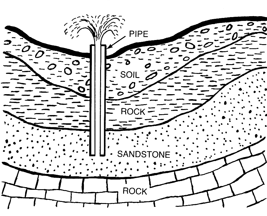
The water in an artesian well flows from an aquifer, which is a
layer of very porous rock or sediment, usually sandstone, capable
of holding and transmitting large quantities of water. The geologic
conditions necessary for an artesian well are an inclined aquifer
sandwiched between impervious rock layers above and below that trap
water in it. Water enters the exposed edge of the aquifer at a high
elevation and percolates downward through interconnected pore
spaces. The water held in these spaces is under pressure because of
the weight of water in the portion of the aquifer above it. If a
well is drilled from the land surface through the overlying
impervious layer into the aquifer, this pressure will cause the
water to rise in the well. In areas where the slope of the aquifer
is great enough, pressure will drive the water above ground level
in a spectacular, permanent fountain. Artesian springs can occur in
similar fashion where faults or cracks in the overlying impervious
layer allow water to flow upward. Water from an artesian well or
spring is usually cold and free of organic contaminants, making it
desirable for drinking.
The aquifer that supplies this well cannot be steep as this
area of Michigan does not have that many hills. But as you approach
the well, you will see that the water is shot out at a steady
volume.
Here is the make up of the Artesian Well:
To log your visit you must:
1) Post a picture of you/your team (with the Artesian well in
the background) within 6 hours of logging this as a “find”.
Include this with your log. A different picture must be posted
with each log.
2) Estimate of the water rate of flow at the Artesian
Well.
This can be done by bringing a container, of known volume,
along with you and time how long it takes to fill.
3)How much and when was the park sold for in the 20's?
4)What is Mr. Wertz's first name and what years was he mayor of
Charlotte?
Each cacher must e-mail me the answer or the log will be
deleted—
Do Not post them in your log.