Pheasant Branch Springs EarthCache
-
Difficulty:
-

-
Terrain:
-

Size:  (not chosen)
Please note Use of geocaching.com services is subject to the terms and conditions
in our disclaimer.
Pheasant
Branch Springs
This is an Earthcache. There is NO
container. See http://www.earthcache.org/ for further
details.
There are (5) requirements listed below that you must complete in
order to log this EarthCache.
Pheasant Branch Springs is located just
north of Middleton in the Pheasant Branch Conservancy. This spring
is the largest and coolest spring that I have seen! Park at N43
07.349 W089 29.461. Follow the path to an observation deck for the
springs. If biking, please leave your bike at the gravel trail when
you turn onto the mowed path to the deck. Please do not leave the
observation deck or mowed trail.
A spring is a natural flow of
groundwater coming through the surface of the earth. Springs occur
when water is absorbed into the ground in the recharge area. The
water then seeps down into an aquifer. An aquifer is a layer in the
ground that is able to hold water.
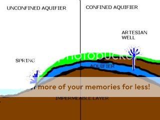
There are two types of aquifers. The most common type and the type
that is at Pheasant Branch Springs is an unconfined aquifer, which
has an impermeable (water cannot go through it freely) layer under
but not above it. Another type and less common aquifer is a
confined aquifer, in which a water supply is sandwiched between two
impermeable layers. These are sometimes called artesian aquifers
because when a well is drilled into this layer, the pressure is so
great that water may spurt to the surface without being pumped.
This is also known as an artesian well.

Here at Pheasant Branch Springs, the water in the unconfined
aquifer can either over flow or seep out through a fault in the
ground. This is what you see happening here.
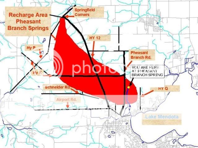
This spring and many more could be lost if the spring’s recharge
area is covered with concrete and asphalt. A recharge area is the
area where water seeps into the ground and replenishes the aquifer.
The diagram below shows the Pheasant Branch Spring recharge area.

Logging
Requirements of this EarthCache:
1. When
logging, please upload a picture of you/and your group (include all
Geocaching names) with your GPSr at the front of the observation
deck so that you do not show the spring in your picture, but that
you can prove that you were there!
Please do not post a picture of the spring itself. It will give
away the answers and besides it is too cool to not let others see
it for themselves!

Then, E-mail
to me the answers to these three questions. Please do not leave the
observation deck! The springs and area around it are a sensitive
area. (Please do not include the answers in your log or it will
have to be deleted.)
2. What do you think is the approximate size of the spring open
water area? (X’ x X’)
3. What type of ground surface (gravel, large rocks, sand, etc.)
does the water come through?
4. What do you estimate is the water depth at this spring?
5. Find the kiosk above the spring on the gravel trail. This sign
tells how many gallons of water flows from these springs each day.
What is the answer?
Sources:
http://www.pheasantbranch.org/pdf/pb_brochure.pdf
http://www.epa.gov
The Geocache Notification Form has been submitted to Jacob Fries
of the Wisconsin DNR. Geocaches placed on Wisconsin Department of
Natural Resource managed lands require permission by means of a
notification form. Please print out a paper copy of the
notification form, fill in all required information, then submit it
to the land manager. The DNR Notification form and land manager
information can be obtained
at:http://www.wi-geocaching.com/hiding
Additional Hints
(No hints available.)