 Access to this site requires a drive along
one of the less traveled dirt roads of the Carrizo Plain.
There are two gates to pass through, neither of which is
locked. Just leave the gates as you find them. Wet weather
will make the roads impassable. No off road vehicle travel is
allowed to reach the site. Collection of plants, rocks, or any
artifacts is prohibited. If turning around, stay within the
road bed and do not go into the field. Practice
Leave No
Trace principles.
Access to this site requires a drive along
one of the less traveled dirt roads of the Carrizo Plain.
There are two gates to pass through, neither of which is
locked. Just leave the gates as you find them. Wet weather
will make the roads impassable. No off road vehicle travel is
allowed to reach the site. Collection of plants, rocks, or any
artifacts is prohibited. If turning around, stay within the
road bed and do not go into the field. Practice
Leave No
Trace principles.
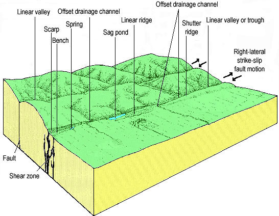
The most prominent feature of this site is a ridge that marks
the main trace of the San Andreas Fault (N35 13.035 W119 46.289).
Ridges can form along fault lines as the friction of the two sides
of the fault which are not exactly straight, push-up the ground and
rocks. Sometimes a scarp such as this one, forms as slight vertical
movement between blocks of rocks drops one side of the fault
relative to the other. It is difficult to determine the difference
between the two sides just by looking at it.
 Click the image for a larger more readable
version.
Click the image for a larger more readable
version.
Another easily recognizable feature, especially if you have
visited Wallace Creek, is an offset stream channel (N35 13.056 W119
46.305). Description of this process is found at Wallace Creek
(link to Wallace Creek EarthCache). The added feature at this
location is a second offset in the same creek (N35 13.013 W119
46.374). This second creek marks a secondary trace of the San
Andres Fault. Major faults such as the San Andreas (which marks the
boundary between two plates) are rarely one single fault but are
actually a bunch of smaller faults that are grouped together, all
having the same relative movement.
A small sag pond can also be found at this location (N35 13.046
W119 46.293). Sag ponds form much the same way as ridges and
scarps. Slight changes in the direction of the fault or movement
between two traces of the fault can also pull two sides of the
fault away from each other creating a depression. This particular
sag pond is quite small.
In the middle of the first offset in the stream is what appears
to be a captured stream (N35 13.061 W119 46.320). Captured streams
form as the offset stream channel crosses in front of a second
channel. Water flowing through the second channel changes direction
and begins flowing down the offset stream channel instead of its
original downstream channel.
Now head northwest along the main fault trace to find a beheaded
channel (N35 13.068 W119 46.371). A beheaded channel was part of a
stream that at one time crossed the fault in a straight line. As
the plates moved, the downstream part of this stream became
separated from the upstream side. This makes it appear as if the
channel starts from nothing. In this case the upstream side of this
beheaded channel may be the captured stream seen in the offset
stream channel.
Logging requirements:
Send me a note with :
- The text "GC1VKD2 Double offset stream and more " on the first
line
- The number of people in your group.
- Using your GPS determine the distance of each of the fault
traces using the two offset (the two offsets begin at N35 13.056
W119 46.305 and N35 13.013 W119 46.374) streams, then determine the
total offset of the stream. How does this relate to the movement of
the San Andreas Fault?
- Determine the distance between the two fault traces. Be sure to
include the name of the Earthcache in your e-mail and the number of
people in your group.
The following sources were used to generate this
cache:
- David K. Lynch 2006, field guide to the San
Andreas Fault, Thule Scientific, Topanga, CA
- Robert E. Wallace Ed. The San Andreas Fault
System, California U.S. GEOLOGICAL SURVEY PROFESSIONAL PAPER 1515,
2. GEOMORPHIC EXPRESSION
http://3dparks.wr.usgs.gov/pp1515/chapter2.html
-
http://3dparks.wr.usgs.gov/haywardfault/html/glossary.html#geomorph
Placement approved by the Carrizo Plains National Monument