Mannum Granite Quarry EarthCache
-
Difficulty:
-

-
Terrain:
-

Size:  (not chosen)
Please note Use of geocaching.com services is subject to the terms and conditions
in our disclaimer.
PLEASE NOTE: Road is now closed to general traffic due to the
dangers of riverbank collapse. You can still walk in to the cache,
but please stay away from the water's edge.
A few kilometres upstream from Mannum on the eastern side of the
Murray River is an area known as 'The Rocks'. This name is thought
to have been derived from the existence of a local granite quarry,
which began operations in 1913. Over half a million tonnes of
granite was carted from this outcrop site to a crusher, before
being conveyed downstream in bins on specially designed
barges.
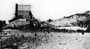
There is very little left of the quarry workings today; indeed only
two concrete blocks and three wharf pylons can be easily found. The
true legacy of this industrial site lies in the fascinating
geological features the quarrying exposed.
The main body of the Mannum Quarry is about 0.8 kilometres in
length and has a maximum width of 0.2 kilometres. The granite found
here is estimated to be 480 million years old.
The present day appearance of the quarry can be divided into four
different sections, based on visible geological features.
1. The intrusion of the dolerite dyke.
The prominent black dyke extends right to the top of the granite in
the quarry.
2. The area north of the dyke.
This area has over 100 fragments of ‘foreign rock’,
called xenoliths, scattered over the face. These xenoliths are
composed of dark igneous rock. They range in size from five to
fifty centimetres in diameter, and became embedded in the granite
as the magmas containing these fragments cooled below the
Earth’s crust.

3. The southern area.
This area has very few small xenoliths, but does have two areas of
badly weathered granite as well as an extremely large xenolith of
some five metres in diameter. Some of the badly weathered granite
appears to be a layered structure. There is also evidence, in the
form of a discard dump, to suggest that the xenolith was once
larger than it is now.
4. The layers above the granite.
The first layer overlies the granite unconformably, and is a
fossil-rich tertiary sandy limestone of some 15 to 20 million years
of age. This limestone is part of what is known as the Mannum
Formation: coral engendered limestone, crowded with the remains of
urchins, shells and other marine fossils. The formation rises near
Murray Bridge, is most prominent in the Mannum region, and tapers
near the Big Bend region of the River Murray. Originally white, the
limestone has been stained a beige colour by years of groundwater
soakage. This stratum is also overlain unconformably by calcrete, a
material that is still forming in the regolith today.


There is evidence at the top of the quarry, in the form of
water-worn granite, to suggest that this outcrop was once an island
in a tertiary sea. Limestone deposits at Mannum, Finniss and Morgan
have provided the evidence that the Lower Murray Basin was a marine
environment for much of the Lower Miocene period (26 to 20 million
years before present).
As you can see, the Mannum Granite Quarry is a site of immense
geological interest. We ask, therefore, that you do not treat it as
a climbing wall or adventure park. If you wish to walk around to
the top of the quarry, please stay back from the edges, as they can
be quite loose and unstable.
A final point: please do not take the fossils.
This Earthcache has two simple requirements.
1. Estimate the width in centimetres of the dolerite dyke.
2. Photograph yourself at the Mannum Quarry.
It’s really not that complicated. Forward these to us and you
may claim your find.
Additional Hints
(No hints available.)
Treasures
You'll collect a digital Treasure from one of these collections when you find and log this geocache:

Loading Treasures