
Mühlbachquellhöhle
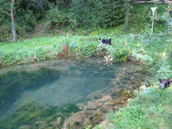
Die große Mühlbachquelle ist mit
einer normalen Schüttung von 300 Litern pro Sekunde eine der
größten Karstquellen der Altmühlalb. Hier tritt der unterirdische
Fluss der „Mühlbachquellhöhle“ aus dem Berg und fließt
der eineinhalb Kilometer entfernten Altmühl zu. Die Quelle wird
zwar oft als „Quelltopf“ bezeichnet, ist aber
eigentlich eine „Hangschuttquelle“, weil sich das
Wasser erst seinen Weg durch die Schuttmassen am Talgrund bahnen
muss.
Anfang Februar 1909 brach an einer
unscheinbaren Stelle am Hang für 27 Stunden ein fünf Meter breiter,
zwei Meter tiefer Bach aus dem Waldboden und bahnte sich seinen
zerstörerischen Weg durch die Ortschaft. Berichte von dem
Hochwasserereignis 1909 ließen Höhlenforscher der
„Karstgruppe Mühlbach“ im Jahr 1998 einen künstlichen
Stollen durch die Hangschuttmassen treiben. Nach 60 Metern gelang
ihnen im Januar 2001 schließlich der Durchbruch in die
Mühlbachquellhöhle, die erste wasseraktive Riesenhöhle der
Fränkischen Alb. Mit einer Gesamtlänge von etwa 7 Kilometern
(Stand: 2005) gehört sie mittlerweile zu den längsten Höhlen
Deutschlands. Ihr Eingang liegt auf Privatgelände und sie ist
aufgrund ihrer Risiken und Schwierigkeiten nur für entsprechend
ausgerüstete Spezialisten zugänglich.
Der höhlenkundliche Weg hat eine
Gesamtlänge von etwa 8 Kilometern und ist als Weg Nummer 6 mit
grüner Schrift auf gelbem Grund ausgeschildert. Die Gesamtgehzeit
beträgt zwischen drei und fünf Stunden. Im Verlauf des Weges findet
ihr 15 Informationstafeln, die euch über unterschiedliche Aspekte
der Höhlenkunde informieren.
Das Altmühltal bietet mit seinen
Kalkschichten hervorragende Bedingungen für die Höhlenbildung. Vor
etwa 150 Millionen Jahren wurden die Kalkschichten des Malm im
Jurameer abgelagert. Durch Bewegungen in der Erdkruste entstanden
in den Kalktafeln Risse, an denen die Höhlenbildung ansetzen
konnte. Durch chemische Kalklösung (Korrosion) und zum geringeren
Teil auch durch mechanische Abtragungen (Erosion) wurden diese
Risse erweitert, so dass sich schließlich ein Netzwerk von
Höhlengängen bilden konnte. Diese Höhlengänge sind während ihrer
Bildung vom Wasser durchflossen. Durch weitere Hebung der
Kalkschichten bzw. durch die langsame Eintiefung von Tälern fallen
sie allmählich trocken und treten in das Verfallsstadium ein. Übrig
bleiben dann kleinere Höhlenreste, die über die Felswände hoch über
dem Tal und in den Erhebungen der Hochfläche zugänglich
sind.
Um die Logaufgaben beantworten zu
können, sind einige Schautafeln aufzusuchen, die sich unweit an
diesem höhlenkundlichen Weg 6 befinden. Es wird je nach Witterung
gutes Schuhwerk empfohlen. Ihr solltet ca. 2 Stunden Zeit dafür
einplanen.
Start bei den Kopfkoordinaten.
Folgt dann dem Wanderweg 6 bis zum Kopfsteinfelsen. Die gesuchten
Informationen findet ihr unterwegs.
Logaufgaben
:
1. Wo durch ist das Biotop
hauptsächlich gefährdet?
2. Wie viele Quelltöpfe gibt es am
Mühlbach?
3. Bei den Koords. N49°01.477
E011°37.492 ist von Ablagerungen die Rede. Wie heißen
diese?
4. Im Text ist die Rede von dem
Begriff „Gesamtdehnungsbetrag“. Um wie viele Meter hat
er sich seit 150 Millionen Jahren
vergrößert?
5. An diesem Punkt befinden sich
Wasserfälle. Wie viele Meter donnert das Wasser in die
Tiefe?
6. Hier ist die Rede von:“
Das xxxxxx – Felsmassiv „Kopfsteinfelsen“ beim
Mühlbach“. Ersetzte die xxx durch den fehlenden
Begriff.
7. Letzte Frage: Was sieht man im
Ostgang?
Die
Antworten schickt bitte über mein Profil. Bitte schreibt die
Lösungen nicht in eure Logs, auch nicht verschlüsselt. Logs ohne
das die Antworten versendet wurden werden gelöscht. Es kann gleich
geloggt werden, Antwortmail vom Owner nur bei ebentuellen
Problemen...;)

Mühlbachquellhöhle (cave with the
spring of the millbrook)
The large
„Mühlbachquelle“ (spring of the millbrook) is with a
normal delivery of 300 litres per second one of the largest karstic
springs of the part of the Swabian Alp where the river
„Altmühl“ (oldmill) flows. Here the submontane river of
the „Mühlbachquellhöhle“ comes to light out of the
mountain and flows to the 1,5 kilometer afar river Altmühl. The
spring is often called „spring pot “, but it is however
actually a „run-off-hill scree spring“, as the water is
forced to find a way through the debris at the bottom of the
valley.
It happened at the beginning of
February 1909 that a five meter wide, two meter deep brook broke
through the hillside out of the forest ground at an unimpressive
place for 27 hours to cleave its destructive way to the village.
Reports about the flood incident 1909 let cave explorer of the
„Karstgruppe Mühlbach“ float a man-made gallery through
the masses of run-off-hill scree in
1998.
In January 2001 after 60 meters the
break-through finally succeeded into the Mühlbachquellhöhle, water
active giant cave of the Frankonian Alp. With a total length of
approximately 7 kilometers (dated: 2005) it belongs meanwhile to
the longest caves of Germany. Its entrance lies on private ground
and it is due to its risks and difficulties only accessible for
suitable equipped specialists.
The speleological trail has an
overall length of approximately 8 kilometers and is marked as way
number 6 with green font on yellow ground. The time to walk the
whole distance amounts between three and five hours. On the course
of the trail you find 15 information boards, which inform you about
different aspects of speleology.
The valley of the river Altmühl
(old mill) provides with its lime layers excellent conditions for
the cave formation. Approximately 150 million years ago the lime
layers of the Malm were deposited in the Jurassic sea. Through
movements in the lithosphere cracks developed in the lime boards,
at which the cave formation could be deposited. By chemical lime
solution (corrosion) and to a smaller part also by mechanical
demolitions (erosion) these cracks were extended, so that finally a
network of cave corridors could form. These cave corridors were
flowed through by water during their formation. By further
elevation of the lime layers and/or by the slow deepening of
valleys they fall gradually dry and enter the decline stage. Then
smaller cave relics remain, which are accessible over the cliffs
high over the valley and in the uprisings of the high
surface.
In order to be able to answer the
questions for logpermission, some presentation boards at the
speleological trail number 6 must be visited. Depending upon
weather conditions good footwear is recommended. You should
schedule approx. 2 hours time for it. Start at the head
coordinates.
Tasks for
logpermission:
1. Whereby is that biotope mainly
endangered?
2. How many spring pots exist at
the „Mühlbach“?
3. At the coords. N49°01.477
E011°37.492 the board
tells about sediments. How are they
called?
4. The text mentioned the term
„Gesamtdehnungsbetrag“ (amount of total extension). How
many meters increased it for 150 million
years?
5. At this presentation board you
found cataracts. How many meters does the water fell into the
depth?
6. The information board talks
about: “the xxxxx - rockmassif „headstonerock “at
the Mühlbach “. Replaced xxx by the missing
term.
7. Last question: What do you see
in the east corridor?
Please send the answers via email using my profile. Please do not
post the solutions - even encrypted - on this site. Logs without
sending the answers will be deleted. You can log your visit
directly, ownermail only if there are any problems...