The Doe River
The Doe flows off Roan Mountain, through the town of the same
name, and cuts through the spectacular Doe River gorge on its way
to join the Watauga in Elizabethton, Tennessee. The gorge, between
Fork Mountain on the south and Cedar Mountain on the north, is 800
to 1,000 feet deep. There are several outstanding rock formations,
the most prominent being Flagpole Point, jutting out sharply on the
right, and Pardee Point, rising high on the left. A small-gauge
railroad, where the original “Tweetsie” of the East Tennessee and
Western North Carolina ran, makes it fairly easy to scout the gorge
on foot. In fact, this is recommended in order for one to fully
appreciate the rugged beauty.

So what is river island?
The term "towhead" implies a small islet or sandbar within a
river (most often the Mississippi river) having a grouping or
thicket of trees, and is often used in the Midwestern United
States. Many rivers, if wide enough, can house considerably large
islands. Which leads to river deltas.River deltas form when a river
carrying sediment another river or a standing body of water, which
in our case is the Watauga River. When the flow enters the water,
it is no longer confined to its channel and expands in width. This
flow expansion results in a decrease in the flow velocity. As a
result, sediment drops out of the flow and deposits. Over time,
this single channel will build a deltaic lobe pushing its mouth
further into the river.
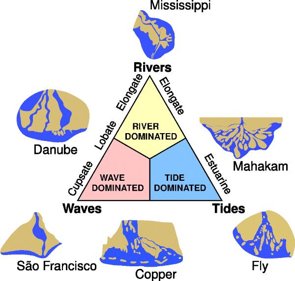
Types of deltas
River-dominated deltas:usually take on a multi-lobed
shape that results from repeated sequences of channel occupation,
offshore deposition, and channel avulsion.
Wave-dominated deltas: wave erosion controls the shape of
the delta,
Tide-dominated deltas: Erosion is also an important
control in tide dominated deltas. which tend to have a few main
distributaries. Once a wave- or river- distributary silts up, it is
abandoned, and a new channel forms elsewhere.
Gilbert deltas:A Gilbert delta (named after Grove Karl
Gilbert) is a specific type of delta that is formed by coarse
sediments, as opposed to gently-sloping muddy deltas
Estuaries:Other rivers, particularly those located on
coasts with significant tidal range, do not form a delta but enter
into the sea in the form of an estuary.
Inland deltas:river delta is located inside a large
valley and is called an inverted river delta. Sometimes a river
will divide into multiple branches in an inland area, only to
rejoin and continue to the sea.
">
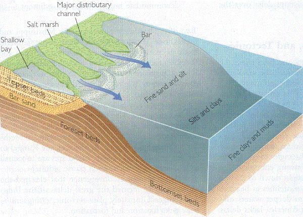
Sedimentary structure
consists of three main forms: the topset, foreset/frontset, and
bottomset
Bottomset:
The bottomset beds are created from the suspended sediment that
settles out of the water as the river flows into the body of water
and loses energy.
Forest bed
:build over the bottomset beds as the main delta form advances.
The foreset beds consist of the bed load that the river is moving
along which consists of larger sediments that roll along the main
channel.
Topset beds
:overlay the foresets, and are horizontal layers of smaller
sediment size that form as the main channel of the river shifts
elsewhere and the larger particles of the bed load no longer are
deposited.
environments of the delta
depends on the interaction between the river's sediment flow and
distribution and the wave and tidal currents; as water flows from
the river's mouth, its velocity decreases and it loses its capacity
to carry sediment
The Watauga River
The Watauga River, 60 mi (97 km) long, originates on the slopes
of Grandfather Mountain in Watauga County, North Carolina, a
mountainous area in western North Carolina and eventually flows
across the Tennessee state line at Johnson County and later
downstream flows into Carter County and then Washington County,
Tennessee.

Sycamore Shoals
The Sycamore Shoals of the Watauga River, usually shortened to
Sycamore Shoals, is a rocky stretch of river rapids along the
Watauga River in Elizabethton, in the U.S. state of Tennessee. The
shoals have long been a significant landmark in the prehistory and
history of the Trans-Appalachian region, first as an early Native
American habitation site and Cherokee gathering place, and later as
the site of numerous events critical to the establishment of the
states of Tennessee and Kentucky and the settlement of the
Trans-Appalachian frontier in general. Today, the shoals are
protected as a National Historic Landmark and are maintained as
part of Sycamore Shoals State Historic Park.
The Sycamore Shoals is located at just over 23 miles (37 km)
upstream from the mouth of the Watauga River, and approximately 3
miles (4.8 km) downstream from the river's confluence with the Doe
River and 11 miles (18 km) downstream from Wilbur Dam. While
managed by the Tennessee Department of Environment and
Conservation, the shoals are located within the municipal
boundaries of Elizabethton. Beyond the shoals, the Watauga flows
for another 8 miles (13 km) before entering its Boone Lake
impoundment.
To claim credit for the following earthcache please do the
following
1.) Take a photo of you and your GPS at the coordinates
2.) Tell me what type of delta we are looking at?
3.) Which type of "bed" are we seeing here as well
4.) which other river does it flow into?