The David Hill Earthcache is located in northeastern New
Mexico east of Mosquero along NM Hwy 39.
The Great Plains east of the Rocky Mountains in Canada and the
United States are characterized by vast expanses of prairie lands.
In eastern New Mexico, the area is referred to generally as the
High Plains. David Hill, in Harding County, is part of the broad
escarpment separating two portions of the High Plains. The
difference in elevation is roughly 750 feet, and the road winds
along sweeping switchbacks from top to bottom. Fortunately, we can
experience the dramatic transition first-hand traveling along La
Frontera del Llano Scenic Byway (NM Hwy 39).
The geology underlying La Frontera del Llano Scenic Byway
between Abbott and Mills varies in type and geologic age. Closest
to Abbott are silt and sand eolian (wind) deposits from the
Quaternary Period (Holocene epoch to Middle Pleistocene stage).
Traveling south are shales from the Cretaceous Period, including
the Greenhorn Formation, Graneros Shale, and Carlile Shale, all of
which are also found in neighboring states.
Near Mills the geology is largely sedimentary material from the
Tertiary period, and Hwy 39 generally follows a wide
northwest/southeast band of this sedimentary material as it passes
through Roy and moves southeast to Mosquero. Heading east from
Mosquero, the road continues primarily on sedimetary deposits until
it reaches David Hill.
At David Hill, the road passes through geologic material from
five distinct periods before arriving at the bottom of the
escarpment. From west to east are alluvial and eolian deposits from
the Tertiary Period, sandstone and shale from the Cretaceous
Period, landslide deposits and colluvium dating from the Quaternary
Period, and gray/red outcrops of the Morrison Formation from the
Jurrasic Period. Entrada Sandstone (Jurrasic) is also visible at
the east end of David Hill and south of the base. Closest to the
base is a band of sedimentary material from the Upper Chinle Group
of the Triassic Period.
From the base of David Hill south toward Logan, Hwy 39 traverses
over alluvium, a mix of sediments deposited by water during the
Holocene epoch to Upper Pleistocene stage of the Quaternary Period.
Immediately west of the highway is the Bull Canyon Formation of
Chinle Group, which is comprised primarily of mudstone and
sandstone.
The primary earthcache coordinates mark the top of the
escarpment at the west side of David Hill. It will also be
necessary to stop at the bottom of the escarpment and part of the
way up or down, depending upon your direction of travel. Each set
of coordinates is near a pull-off from the highway, but please
exercise caution when leaving or entering the road.
 |
Sample Logging Photo
Showing David Hill
Descent |
................................................................................................................
To Log this Earthcache
1) Visit all three sets of
coordinates. Record elevation readings at the top and bottom of the
escarpment.
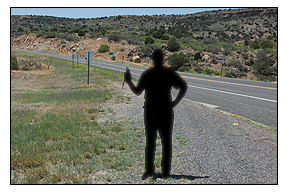
2) Have your photograph
taken at the top and the bottom of the site with your GPSr so that
some portion of the ascending and descending roadway is visible, as
shown in the sample logging photos. For solo cachers, a photo of
your hand holding your GPSr at the sites is certainly fine. If your
GPSr and phone are in one unit (e.g., an iPhone with Geocaching
app), creative photos of your choosing at the sites are also
acceptable.
3) Immediately before
logging your find, e-mail the answers to the following questions
using this link. Do not post the answers in your
log!
Go to these coordinates: N 35° 47.400 W 103° 49.301 - the
pull-off is on the right as you climb the hill. Questions -
Looking perpendicular from the roadway you will see a large object
that has fallen. Are there other features like it on David Hill?
How do you suppose it came rest in this position? Best guesses are
okay! If weather or other conditions prevent you from completing
this portion of the earthcache, please let me know.
4) Log your find, and
include the elevations you recorded at the top and bottom. Please
also upload your photographs when you log your find. Logs without
at least two photographs will be deleted, hence the (albeit modest)
difficulty rating.
 |
Sample Logging Photo
Showing David Hill
Ascent |
................................................................................................................
David Hill was named for the ghost town of David, New Mexico,
which was near the base of the hill. The town was large enough to
support a post office from 1915 to 1922. A cemetery is about all
that remains of the town.
My abrupt introduction to David Hill was in 1981; I was
traveling with friends from Cimarron to Tucumcari, and was asleep
in the rear of a 1960s VW minivan when we started down the hill.
Too much speed, a sharp turn, and I was thrown from one side to the
other. The driver regained control, but several miles from the
bottom we had a massive blowout, no doubt from damage sustained
high on the hill. My subsequent visits have been less eventful, and
this is my favorite way to approach the mountains from
Amarillo.
Click to view a video of the descent of David
Hill
................................................................................................................
Information for this earthcache was gathered from several
sources, including New Mexico Tech's
New Mexico Bureau of Geology & Mineral Resources map
page.